Method and system for monitoring water quality indexes of landscape aquaculture water
A monitoring system and aquaculture water technology, applied in the field of water quality monitoring, can solve the problems of large sampling error, difficulty in meeting the effective water environment management of governments and enterprises, and inability to timely reflect changes in pollution, and achieve the effect of ensuring reliability and stability.
- Summary
- Abstract
- Description
- Claims
- Application Information
AI Technical Summary
Problems solved by technology
Method used
Image

Examples
Embodiment 1
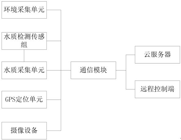
[0045] The invention discloses a monitoring system for water quality indicators of landscape aquaculture water, comprising:
[0046] The environment acquisition unit is used to obtain the current environment characteristics in real time;
[0047] Multiple water quality detection sensor groups are used to obtain the current electrical signals of water quality parameters at different collection points in real time;
[0048] The water quality acquisition unit is used to analyze the electrical signal of the current water quality parameters to obtain the current water quality characteristics;
[0049] GPS positioning unit, one-to-one correspondence with multiple water quality detection sensors, used to obtain the location parameters of the collection point;
[0050] The camera equipment is used to collect the water quality image of the current collection point and the image near the collection point, directly observe the color of the water, floating objects, etc. through the water...
Embodiment 2
[0068] The invention discloses a method for monitoring water quality indicators of landscape aquaculture water, which is characterized in that it includes a cloud server, a remote control terminal, a GPS positioning unit connected to the remote control terminal, and an imaging device. The monitoring method includes the following steps:
[0069] Select the scope of the basin to be tested for water quality;
[0070] Use the remote control terminal to start the GPS positioning unit to obtain the location parameters of the collection point;
[0071] The cloud server receives the location parameter, and selects the collection point within the water quality basin to be tested;
[0072] The remote control end starts the camera equipment at the selected collection point to obtain water quality images;
[0073] The cloud server obtains the real-time environmental characteristics, water quality characteristics, and water quality images of the selected collection points, and analyzes th...
PUM
 Abstract
Description
Claims
Application Information
 - Generate Ideas
- Intellectual Property
- Life Sciences
- Materials
- Tech Scout
- Unparalleled Data Quality
- Higher Quality Content
- 60% Fewer Hallucinations
Browse by: Latest US Patents, China's latest patents, Technical Efficacy Thesaurus, Application Domain, Technology Topic, Popular Technical Reports.
© 2025 PatSnap. All rights reserved.Legal|Privacy policy|Modern Slavery Act Transparency Statement|Sitemap|About US| Contact US: help@patsnap.com