Adjustable SINS, DVL and USBL integrated navigation method

An integrated navigation and adjustable technology, applied in the field of navigation, can solve problems such as accumulation of navigation errors, data jumps, and inability to work for a long time, and achieve the effects of reducing inertial navigation errors, improving accuracy, and improving work adaptability

Pending Publication Date: 2022-01-21
HEBEI HANGUANG HEAVY IND
View PDF0 Cites 1 Cited by
  • Summary
  • Abstract
  • Description
  • Claims
  • Application Information

AI Technical Summary

Problems solved by technology

[0003] Among them, the strapdown inertial navigation system (SINS) is composed of gyroscopes, accelerometers, navigation computers, etc., which can realize autonomous navigation. The accelerometer's measurement is used to calculate the position and speed of the carrier through the navigation calculation of its navigation computer. , using the measurement of the gyroscope to output the attitude and heading information of the carrier, it can provide attitude, speed and position information for the underwater carrier, but its navigation error accumulates with time, and the navigation accuracy of the system decreases, so it cannot work alone for a long time; The Velocimeter (DVL) is a navigation device that measures the speed of the carrier based on the Doppler effect. It measures the speed of the DVL relative to the bottom of the water through the Doppler effect, and can provide high-precision continuous speed information. It is a commonly used auxiliary navigation device. However, SINS, The speed measurement error of the DVL integrated navigation system is easily affected by factors such as water temperature, seawater salinity, and beam width. There is a problem that the DVL sound wave cannot reach the bottom of the water, or when the underwater geology is silt and other highly absorbing substances, the DVL sound wave cannot return. Question: The ultra-short baseline positioning system (USBL) provides the three-dimensional position information of the carrier based on the principle of acoustic positioning. It has high positioning accuracy, simple operation, strong portability, and low cost. The position of the transponder is known precisely, and the position information of the USBL can be obtained by measuring the relative position information of the transponder relative to the base array (including angle information and slope distance information), which can be used as an auxiliary navigation system to suppress the divergence of inertial navigation system errors However, it is easily affected by the marine environment, and data jumps or data loss may occur. The combination of SINS and USBL is not easy to achieve long-distance integrated navigation, and generally only works in specific waters.
[0004] To sum up, the existing navigation system has poor adaptability and cannot complete navigation in various situations.

Method used


Image

  • Adjustable SINS, DVL and USBL integrated navigation method
  • Adjustable SINS, DVL and USBL integrated navigation method
  • Adjustable SINS, DVL and USBL integrated navigation method

Examples


Embodiment Construction

[0073] The present invention will be described in detail below with reference to the accompanying drawings and examples.

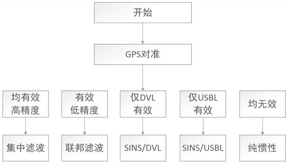
[0074] A kind of adjustable SINS, DVL, USBL combined navigation method of the present invention, flow chart such as figure 1 shown, including the following steps:

[0075] Initial alignment is achieved by collecting SINS information and Global Positioning System (GPS) information;

[0076] After the alignment is completed, the position and speed of SINS, the speed of DVL, and the position data of USBL are collected synchronously for combined navigation in various situations. SINS, DVL, and USBL can judge the valid bits of their own output information in real time (divided into: valid, invalid ) and whether the corresponding accuracy is higher than the set value when the output information is valid (higher than the set value is high precision, not higher than the set value is low precision), select different filtering methods according to specific situatio...


PUM


Abstract

According to the adjustable SINS, DVL and USBL integrated navigation method, the operation mode can be adjusted according to various actual conditions, advantage complementation is achieved, work adaptability of the whole system is improved, and integrated navigation under various conditions is completed. In the actual use of SINS, DVL and USBL integrated navigation, an adjustable flexible integrated navigation mode is adopted for different conditions, and accurate estimation of inertial navigation errors is obtained. According to the combined navigation system, complementary advantages can be realized, working adaptability of the whole system is improved, combined navigation under various conditions is completed, inertial navigation errors are effectively reduced by an adjustable flexible combined navigation mode, and precision of the combined navigation system is improved.

Description

technical field [0001] The invention relates to the technical field of navigation, in particular to an adjustable SINS, DVL and USBL combined navigation method. Background technique [0002] Several navigation devices commonly used at present include Strapdown Inertial Navigation System (SINS), Doppler Velocimeter (DVL) and Ultra Short Baseline Positioning System (USBL). [0003] Among them, the strapdown inertial navigation system (SINS) is composed of gyroscopes, accelerometers, navigation computers, etc., which can realize autonomous navigation. The accelerometer's measurement is used to calculate the position and speed of the carrier through the navigation calculation of its navigation computer. , using the measurement of the gyroscope to output the attitude and heading information of the carrier, it can provide attitude, speed and position information for the underwater carrier, but its navigation error accumulates with time, and the navigation accuracy of the system de...

Claims


Application Information

Patent Timeline
Patent Type & Authority Applications(China)
IPC IPC(8): G01C21/16G01C21/20
CPCG01C21/165G01C21/20
Inventor 靳聪慧韩袁昭可伟姜校亮马西保
Owner HEBEI HANGUANG HEAVY IND
Why Eureka
Try Eureka