A rapid extraction method for the height of tree obstacles in power grid transmission lines

A technology of transmission lines and extraction methods, which is applied in the field of remote sensing image power grid security applications, can solve the problems that cannot meet the safety monitoring of high-voltage transmission lines, and the accuracy of tree height measurement cannot be guaranteed, so as to make up for manual inspections and UAV inspections. Check and improve the effect of application ability

Active Publication Date: 2022-07-12
北京四象爱数科技有限公司
View PDF0 Cites 0 Cited by
  • Summary
  • Abstract
  • Description
  • Claims
  • Application Information

AI Technical Summary

Problems solved by technology

The Ziyuan No. 3 three-dimensional surveying and mapping satellite launched by my country is a milestone in the development of surveying and mapping in my country. Its front-view, rear-view and front-view panchromatic ground spatial resolutions are 3.5 meters, 3.5 meters and 2.1 meters respectively. The ground spatial resolution of the multispectral camera With a length of 6 meters, it can be used as production data for large-scale topographic maps, but there are still shortcomings in stereo mapping with high precision requirements such as forest obstacles
The existing tree height calculation model uses the difference between the DSM and the digital elevation model (DEM) to obtain the tree height in a large area, but the DEM is still generated by interpolation of the topographic map collected in the previous stage, so the measurement accuracy of the tree height cannot be guaranteed. Can not meet the requirements of high-voltage transmission line safety monitoring

Method used


Image

  • A rapid extraction method for the height of tree obstacles in power grid transmission lines
  • A rapid extraction method for the height of tree obstacles in power grid transmission lines
  • A rapid extraction method for the height of tree obstacles in power grid transmission lines

Examples


Embodiment

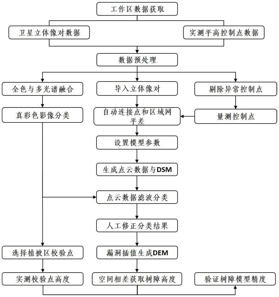
[0042] The following takes the application project of multi-load satellite remote sensing in a high-voltage power grid channel safety monitoring in a certain place in Sichuan as an example, and describes a method for quickly extracting the height of tree obstacles in a power grid transmission line provided by the present invention.

[0043] According to the overall requirements and technical indicators of the project, basic data collection is carried out, mainly including sub-meter resolution Pleiades optical remote sensing data, inertial navigation RTK equipment, power grid transmission line area vector, national standards and technical means for transmission line channel inspection. Integrate panchromatic and multispectral fusion processing of Pleiades stereo pair data; lay out control point positions on true-color images and use inertial navigation RTK to collect control points of the same name; import stereo pairs, RPC files, and level heights into the Inpho aerial survey pr...


PUM


Abstract

The invention discloses a method for quickly extracting the height of tree obstacles in power grid transmission lines, which adopts sub-meter high-resolution optical stereo image and RPC files, combined with high-precision control points collected on the ground, and extracts high-precision surface DSM and points through processing. Cloud data; on this basis, the filter classification technology is used to classify the point cloud data, and the ground points in the classification result are corrected by integrating the features of the ground objects in the satellite image, and the DEM is generated by interpolation; finally, the spatial difference based on DSM and DEM is established. The model's tree canopy height extraction method is used to verify the accuracy of the method through field collection points. The invention solves the problem that the height extraction precision is out of control due to DEM in the original spatial difference calculation model.

Description

technical field [0001] The invention belongs to the field of remote sensing image power grid security application, and in particular relates to a method for quickly extracting the height of tree obstacles in high-voltage transmission lines. Background technique [0002] High-voltage transmission lines directly use air as an insulator. Usually, the height design of transmission lines follows national standards. However, due to tree growth or extreme weather, trees will contact or be close to power lines, and trees are prone to conduct electricity or line tripping, jeopardizing the safe operation of power lines. This can lead to power outages, fires in severe cases, and heavy economic losses. According to the operation regulations of overhead transmission lines in my country, when the lines of 220KV and above require the maximum sag, the safety distance between the conductors and the trees should be no less than 4.5 meters. In order to prevent the occurrence of safety acciden...

Claims


Application Information

Patent Timeline
Patent Type & Authority Patents(China)
IPC IPC(8): G06V20/13G06V10/764G06K9/62G06Q50/06
CPCG06Q50/06G06F18/241Y04S10/50
Inventor 俞雷郑勇侯从强姚勇航陈芳莉唐洪城张宇航
Owner 北京四象爱数科技有限公司
Why Eureka
Try Eureka