Underwater traverse measurement method and device for acquiring seabed control point data

A technology of wire survey and control point, applied in the direction of measuring device, height/level measurement, radio wave measurement system, etc., can solve the problem of scientifically and objectively reflecting the shape, structure and change of the seabed, and the temporal state of multi-source seabed observation data , data model, spatial reference, scale, precision difference and other issues, to achieve the effect of strong adaptability, wide application prospects, and simple deployment and recovery

Pending Publication Date: 2022-03-25
TIANJIN UNIV
View PDF0 Cites 1 Cited by
  • Summary
  • Abstract
  • Description
  • Claims
  • Application Information

AI Technical Summary

Problems solved by technology

[0003] Traditional bathymetry technology, together with modern technologies such as high-precision satellite positioning technology, dynamic attitude monitoring technology, and multi-beam bathymetry system, has enriched the acquisition methods of seabed terrain data, but there are still many problems in the expression and application of seabed topography data. Due to the difference in the vertical datum, only the original observation data cannot scientifically and objectively reflect the shape, structure and changes of the seabed
Compared with surface observation data, seabed observation data involves geoid, depth datum and reference ellipsoid, etc. Obtaining redundant seabed observation data of multiple different vertical datums at the same time is the basis for the synthesis of seabed landform data and the construction of seabed topography model However, there are differences in the temporality, data model, spatial reference, scale, and accuracy of these multi-source seabed observation data. Whether it is the representation of seabed topography or the study of seabed bottom, it will involve the normalization of multi-source seabed observation data. Therefore, it is necessary to realize the transformation of marine multi-reference data and the synthesis of multi-reference data, and to reveal the relationship between the earth's gravity field, tidal field and geometric field

Method used


Image

  • Underwater traverse measurement method and device for acquiring seabed control point data
  • Underwater traverse measurement method and device for acquiring seabed control point data
  • Underwater traverse measurement method and device for acquiring seabed control point data

Examples


Embodiment 1

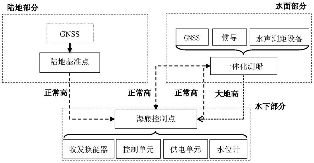
[0041] see Figure 1 to Figure 2 , the embodiment of the present invention provides an underwater wire survey method for simultaneously obtaining three types of data of geodetic height, normal height, and water depth of a seabed control point. Control point; an integrated survey ship equipped with GNSS, inertial navigation and hydroacoustic ranging equipment and a land reference point.

[0042] The method includes the following steps:

[0043] Step 1: Obtain geodetic height data using the principle of inverted long baseline positioning;

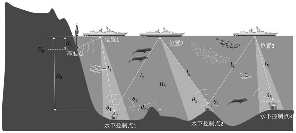
[0044]The geodetic height of the seabed control point is measured by the principle of inverted long baseline. There are n self-made seabed control points (or called underwater control points) on the bottom of the sea. For the short baseline system, the deployed ship travels around the sea surface to collect data through the GNSS equipment on the survey ship, and then measures the echo time of a single control point on the seabed at multiple...

Embodiment 2

[0055] The scheme in embodiment 1 is further introduced below in conjunction with specific examples, see the following description for details:

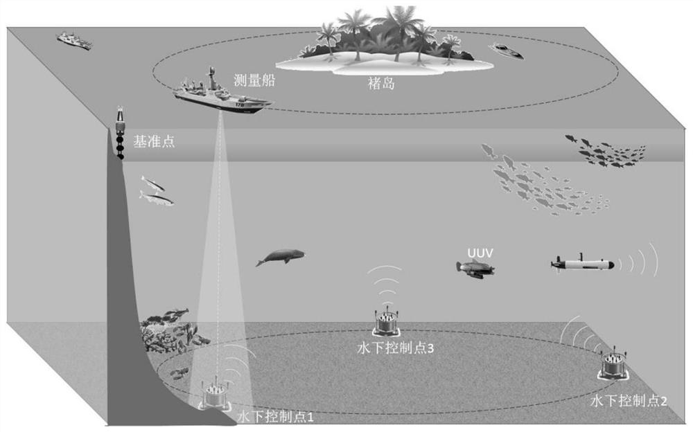
[0056] Such as Figure 1-Figure 2 As shown, it is a schematic diagram of the structural principle of the underwater wire survey method and a schematic diagram of the working principle of the seabed control point for simultaneously obtaining three types of data of the geodetic height, normal height and water depth of the seabed control point according to the embodiment of the present invention. Focusing on the inspection of seabed control points (transponders) in a certain range offshore, the self-developed equipment equipped with transceiver transducers, transponders and water level gauges will be used as seabed control points, and the underwater wire measurement mode will be designed. It will be equipped with GNSS, The integrated survey ship of inertial navigation and underwater acoustic ranging equipment is used as the core observa...

Embodiment 3

[0089] An underwater traverse device for obtaining seabed control point data, see Image 6 , the device includes: a processor and a memory, the memory stores program instructions, and the processor invokes the program instructions stored in the memory to make the device execute the method steps in Embodiments 1 and 2;

[0090] Design the underwater wire measurement mode, and use the integrated survey ship equipped with GNSS, inertial navigation and underwater acoustic ranging equipment as the core observation instrument;

[0091] Taking the GNSS leveling point of the land reference point as a reference, supplemented by a tide gauge or a water level gauge, through the inverted long baseline positioning principle, transmitting the reference value and the average water level gauge, the geodetic height, normal height and water depth of the seabed control point are respectively obtained. data.

[0092] Among them, the underwater traverse measurement mode is designed as follows:

...


PUM


Abstract

The invention discloses an underwater traverse measurement method and device for acquiring submarine control point data, and the method comprises the following steps: designing an underwater traverse measurement mode, and taking an integrated measurement ship carrying GNSS, inertial navigation and underwater sound ranging equipment as a core observation instrument; a GNSS benchmark of a land datum point is used as a reference, a tide gauge or a water level gauge is used as an auxiliary, and three types of data of geodetic height, normal height and water depth of a seabed control point are respectively obtained through an inverted long baseline positioning principle, a transmission datum value and an average water level gauge. The device comprises a processor and a memory.

Description

technical field [0001] The invention relates to the field of underwater wire measurement, in particular to an underwater wire measurement method and device for acquiring seabed control point data, that is, the method can simultaneously acquire three types of data. Background technique [0002] The ocean is an important space for the sustainable development of human beings. It stores abundant natural resources and is also the main driving force affecting the global environment and climate change. Whether it is the development of marine resources, maritime economic activities, maintenance of marine rights and interests, or marine scientific research, seabed topography (map) is an essential basic geographic information. Seabed topography reflects the ups and downs of the solid surface at the bottom of the ocean, the distribution of seabed features, and the elements of seabed geological types. The representation of seabed topography mainly depends on the accumulation, analysis ...

Claims


Application Information

Patent Timeline
IPC IPC(8): G01C13/00G01C5/00G01S15/08G01S19/42G01S19/53G01S19/49G01D21/02B63B49/00
CPCG01C13/00G01C13/008G01C5/00G01S15/08G01S19/53G01S19/42G01S19/49G01D21/02B63B49/00B63B2201/00
Inventor 翟京生王晓健钱治文郭博峰李杰孙万忠
Owner TIANJIN UNIV
Why Eureka
Try Eureka