
Water conservancy project unmanned aerial vehicle for remote sensing surveying and mapping

A water conservancy project and unmanned aerial vehicle technology, applied in the field of unmanned aerial vehicles, can solve problems such as damage to surveying and mapping instruments, large impact force, and high risk of surveying and mapping, and achieve the effects of increasing efficiency and stability, increasing stability, and increasing efficiency

Pending Publication Date: 2022-03-29
信阳市水利勘测设计院
View PDF0 Cites 0 Cited by
  • Summary
  • Abstract
  • Description
  • Claims
  • Application Information

AI Technical Summary

Problems solved by technology

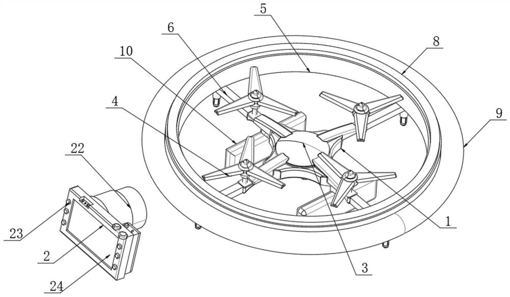
[0004] To this end, the embodiment of the present invention provides a water conservancy engineering drone for remote sensing surveying and mapping, to solve the problem that when the drone lands too fast in the prior art, or loses power in the air, there is a great possibility that the surveying and mapping The instrument is damaged, and at the same time, the cost of the surveying and mapping instrument is high, resulting in a greater risk of surveying and mapping. At the same time, when the drone lands, the tripod of the drone may transmit a large impact to the drone body, which may easily cause unmanned Unsteady landing problem

Method used


Image

  • Water conservancy project unmanned aerial vehicle for remote sensing surveying and mapping
  • Water conservancy project unmanned aerial vehicle for remote sensing surveying and mapping
  • Water conservancy project unmanned aerial vehicle for remote sensing surveying and mapping

Examples


Embodiment Construction

[0031] In the following, embodiments of the present invention will be described below, and those skilled in the art can easily understand other advantages and efficacy of the present invention, apparently, as described in the present invention. , Not all of the embodiments. Based on the embodiments of the present invention, all other embodiments obtained by those of ordinary skill in the art are in the range of the present invention without making creative labor premise.

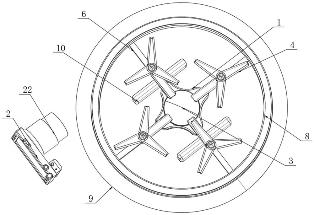
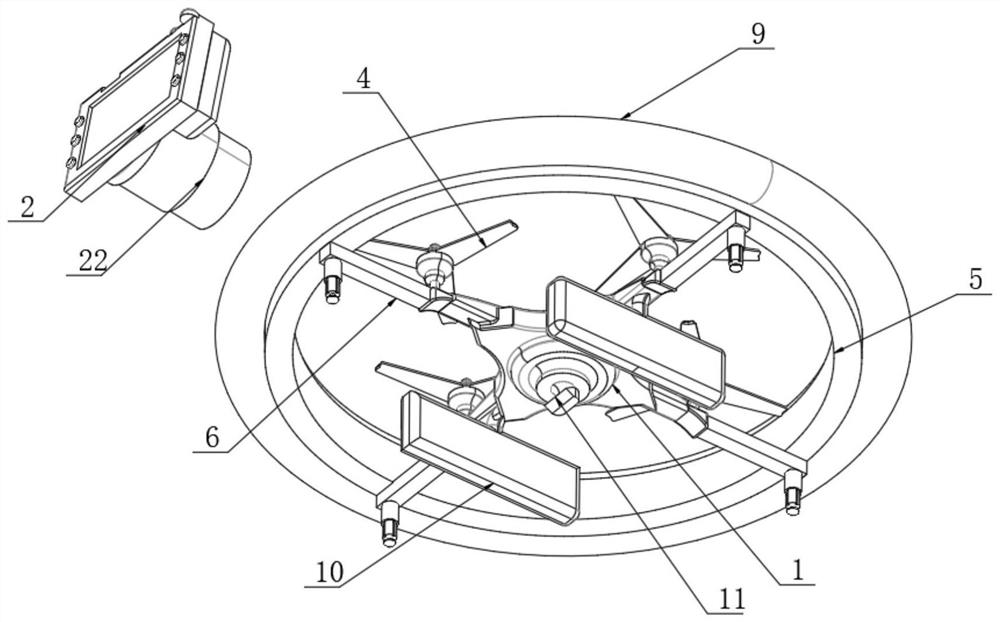
[0032] Refer to the instructions Figure 1-7 A hydraulic engineer drone for remote sensing mapping, including the body 1 and the body 1 wirelessly connected by the wireless signal generator 22, the top of the body 1 is provided with solar photovoltaic assembly 3, the top of the body 1 A drive assembly is provided at the angle of the quadrangular angle, and a protective assembly is provided on the outside of the body 1.

[0033] The protective assembly includes a reinforcing protective support retaining ring 5 dis...


PUM


Abstract

The embodiment of the invention discloses a water conservancy project unmanned aerial vehicle for remote sensing surveying and mapping, and belongs to the technical field of unmanned aerial vehicles, the water conservancy project unmanned aerial vehicle comprises a vehicle body and a controller wirelessly connected with the vehicle body through a wireless signal generator, a solar photovoltaic module is arranged at the top of the vehicle body, and driving modules are arranged at the four corners of the top of the vehicle body; a protection assembly is arranged on the outer side of the machine body. Through corresponding cooperative use of all the structures, the unmanned aerial vehicle can be prevented from falling off from the high altitude due to insufficient power, the stability of the unmanned aerial vehicle during falling is improved, the resistance between fan blades and air can be reduced, the unmanned aerial vehicle can be filled with gas in an extremely short time, the unmanned aerial vehicle is protected, and the unmanned aerial vehicle is prevented from being damaged; meanwhile, through the arrangement of a reinforcing protection supporting check ring and an air bag on the outer side of the unmanned aerial vehicle body, when the unmanned aerial vehicle makes contact with pedestrians in the using process, the reinforcing protection supporting check ring and the air bag protect the pedestrians, and when the unmanned aerial vehicle collides with the object surface in the using process, the unmanned aerial vehicle is protected.

Description

Technical field [0001] Embodiments of the present invention relate to the field of drone, and more particularly to a water conservancy engineering drone for remote sensing mapping. Background technique [0002] The drone is a non-supported aircraft that utilizes radio remote control equipment and self-propelled control devices. At present, drones are widely used in water conservancy measurements, water conservancy and hydropower projects are getting higher and higher, traditional Engineering measurement technology cope with high-precision, real-time data information collection work has certain tributies, drones have unparalleled superiority in remote sensing measurements with its own characteristics of flexible, high-resolution, low cost, high efficiency. sex. [0003] At present, the existing water conservancy engineering mapping is large to increase the surveying and mapping in the drone, while the drone has too fast, or when there is a power in the air, there is a great possib...

Claims


Application Information

Patent Timeline
Patent Type & Authority Applications(China)
IPC IPC(8): B64C39/02B64C27/20B64D27/24B64C25/64
CPCB64C39/024B64C27/20B64D27/24B64C25/64B64D27/353Y02T50/60
Inventor 李燃向广银申圆文陈先锦陈涛张涛张煜明王巍陈满新陈大臣邓思章继民冯国强
Owner 信阳市水利勘测设计院
Learn More