Ship-shore satellite link construction and operation method based on polar sea area fishery service system

A service system and satellite link technology, applied in the field of marine fishery system services, can solve problems such as unseen research and technology realization

Pending Publication Date: 2022-04-12
EAST CHINA SEA FISHERIES RES INST CHINESE ACAD OF FISHERY SCI +1
View PDF0 Cites 0 Cited by
  • Summary
  • Abstract
  • Description
  • Claims
  • Application Information

AI Technical Summary

Problems solved by technology

[0003] However, with the gradual development of Antarctic marine biological resources and the scarcity of satellites in orbit in the polar region, information such as sea conditions, fishing conditions, and weather in the operating area need to be transmitted to the ship's end in a timely manner, and some sonar, pictures and other data on the ship's end also need to be transmitted in time To the shore system, however, there is no related research and technology realization at home and abroad
Therefore, the two-way interconnection of ship-side and shore-side data transmission has become an urgent problem. At the same time, construct a commercial operation method and case demonstration based on the fishery service system to improve the ship-shore satellite link guarantee and fishery prediction and analysis capabilities in polar seas It is extremely important for the safe production of enterprise fishing boats, but related methods have not been reported yet

Method used


Image

  • Ship-shore satellite link construction and operation method based on polar sea area fishery service system
  • Ship-shore satellite link construction and operation method based on polar sea area fishery service system
  • Ship-shore satellite link construction and operation method based on polar sea area fishery service system

Examples


Embodiment 1

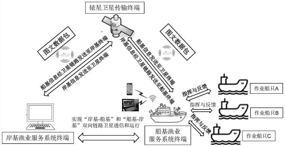
[0030] A method for building and operating a ship-to-shore satellite link based on a fishery service system in polar seas, the specific steps are as follows:

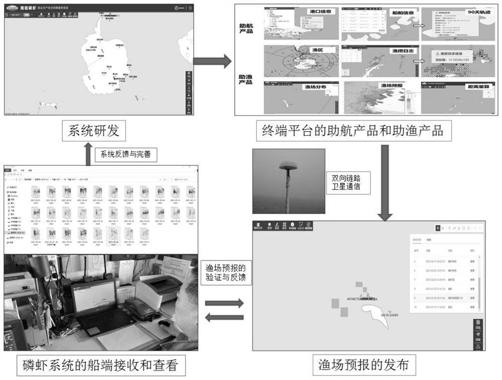
[0031] First, use WEBGIS technology to build a system for the marine environment and geographic information of the Southern Ocean. Open Google Chrome and enter the login URL. The system has conventional user management functions. Enter the user name and password to log in to the system and enter the main page . The system uses Google browser as the basic browser for research and development, including real-time viewing, historical retrieval and forecasting of meteorological and sea state data; it realizes the monitoring and management of operating ships, integrates fishing forecast information, and provides a single-point query function of weather and sea state at any point and fishing grounds fast forecast function.

[0032] Secondly, through the construction of the polar satellite communication link, the "shore-ship-...


PUM


Abstract

The invention discloses a ship-shore satellite link construction and operation method based on a polar sea area fishery service system, and the method comprises the following steps: (1) carrying out the projection of a high-latitude or polar sea area through employing a polar coordinate projection mode, and carrying out the asymmetric spacing grid division of a fishing ground area; (2) performing thematic map publishing on the fishery condition elements by a publishing technology; (3) the shore-based fishery service terminal compresses the made graphic and text information and then sends the graphic and text information to the iridium satellite constellation network every day, and the graphic and text information is sent to the ship-based fishery service terminal through the iridium satellite transmission terminal; and (4) the operation ship feeds back to the ship-end fishery service terminal according to the actual offshore production condition. Based on ship-shore double-link intercommunication, a new method is provided for operation and release of a polar region fishery service system, the functions of ship-base-shore-base and shore-base-ship-base two-way link satellite communication are achieved, and the fishing assisting functions such as receiving and displaying of a krill system fishery fishing condition product map from a shore base to a ship end, fishery decision making and commanding are achieved.

Description

technical field [0001] The invention relates to the field of marine fishery system services, in particular to a method for building and operating a ship-to-shore satellite link of a polar sea area fishery service system. Background technique [0002] Since my country started Antarctic krill exploration in 2009, the scale of Antarctic krill exploration has expanded steadily, and a series of results have been achieved. There have also been major breakthroughs in key technologies such as fishing gear, fishing methods, and product processing that restrict the development of my country's Antarctic krill industry. [0003] However, with the gradual development of Antarctic marine biological resources and the scarcity of satellites in orbit in the polar region, information such as sea conditions, fishing conditions, and weather in the operating area need to be transmitted to the ship's end in a timely manner, and some sonar, pictures and other data on the ship's end also need to be ...

Claims


Application Information

Patent Timeline
IPC IPC(8): G06F16/29G06Q50/02
Inventor 张衡韩海斌杨超商宸
Owner EAST CHINA SEA FISHERIES RES INST CHINESE ACAD OF FISHERY SCI
Why Eureka
Try Eureka