Method for measuring shallow sea water depth based on satellite-borne single-photon laser radar data

A laser radar and data measurement technology, applied in the field of aerospace remote sensing mapping, can solve the problems of airborne single-photon laser radar equipment and related data scarcity and rareness

Pending Publication Date: 2022-04-15
中国人民解放军61540部队
View PDF0 Cites 4 Cited by
  • Summary
  • Abstract
  • Description
  • Claims
  • Application Information

AI Technical Summary

Problems solved by technology

[0006] At present, my country has not launched relevant single-photon lidar satellites, and airborne single-photon lidar equipment and related data are also very scarce. Relevant research based on single-photon lidar ...

Method used


Image

  • Method for measuring shallow sea water depth based on satellite-borne single-photon laser radar data
  • Method for measuring shallow sea water depth based on satellite-borne single-photon laser radar data
  • Method for measuring shallow sea water depth based on satellite-borne single-photon laser radar data

Examples


Embodiment Construction

[0040] The following will clearly and completely describe the technical solutions in the embodiments of the present invention with reference to the accompanying drawings in the embodiments of the present invention. Obviously, the described embodiments are only some, not all, embodiments of the present invention.

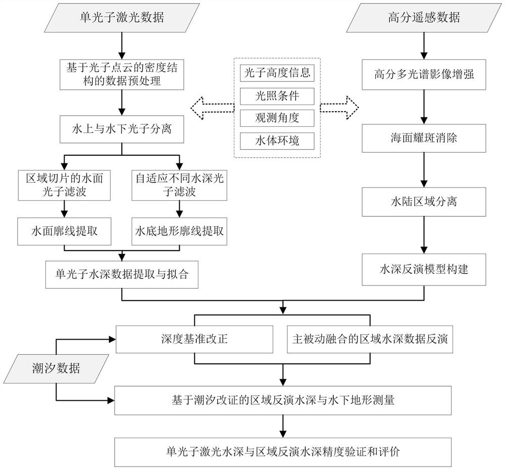
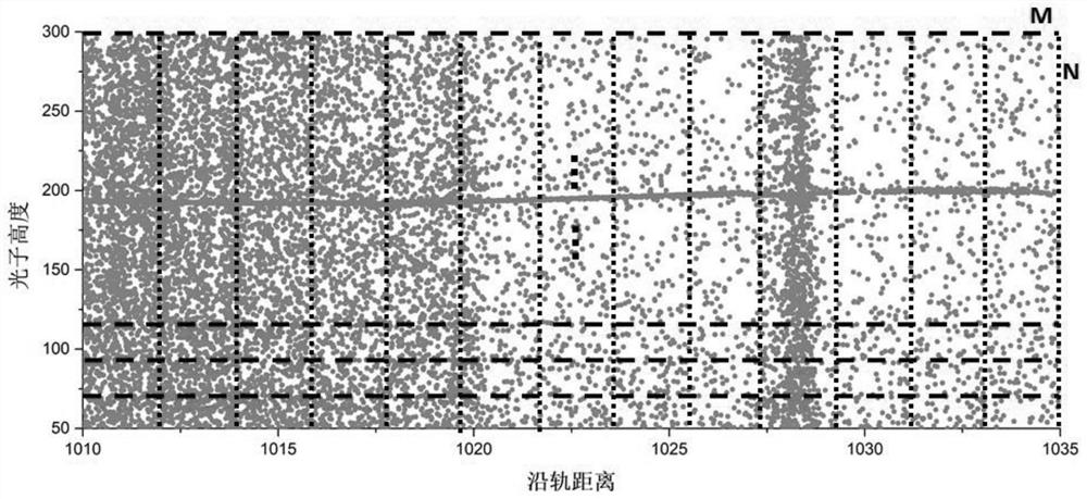
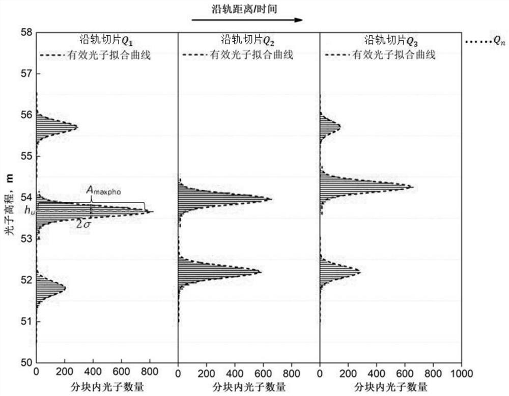
[0041] refer to figure 1 , the present invention provides a method for measuring shallow sea depth based on spaceborne single-photon lidar data. The initial filtering model; then analyze the spatial density distribution of photon point clouds in different environments based on the initial filtering results, build a water surface and underwater photon point cloud separation model, and realize the extraction of effective photon signals and ocean wave profiles on the water surface; then according to the different environments The spatial density distribution characteristics of underwater photon point clouds at different water depths, construct an adaptive photon density...


PUM


Abstract

A method for measuring shallow sea water depth based on satellite-borne single-photon laser radar data comprises the following steps: firstly, analyzing photon signal and noise elevation characteristics of a satellite-borne single-photon laser radar in a shallow sea area in different environments, and constructing an initial filtering model of a photon point cloud; analyzing the spatial density distribution of the photon point clouds in different environments based on the initial filtering result, constructing a water surface and underwater photon point cloud separation model, and realizing the extraction of water surface effective photon signals and sea wave profiles; according to the spatial density distribution characteristics of underwater photon point clouds in different environments at different water depths, a self-adaptive photon density filtering model changing along with the water depth and a water depth extraction method are constructed, and the water depth measurement capability and precision of the satellite-borne single-photon laser radar are analyzed; finally, based on the relation between the water depth detection result of the satellite-borne single-photon laser radar and the remote sensing reflectivity spectrum, active-passive fusion high-precision regionalized shallow sea water depth inversion is carried out through satellite-borne multi-source remote sensing data, and domestic and overseas high-precision shallow sea water depth data extraction is achieved.

Description

technical field [0001] The invention relates to the technical field of aerospace remote sensing surveying and mapping, in particular to a method for measuring shallow sea depth based on spaceborne single-photon laser radar data. Background technique [0002] my country has a vast sea area of ​​more than 3 million square kilometers, 18,000 kilometers of mainland coastline, 14,000 kilometers of island coastline, more than 11,000 islands, and 500,000 square kilometers of shallow sea area with a water depth of less than 50 meters. At present, my country's access to global elevation data mainly relies on satellite remote sensing technology. Due to the restriction of elevation accuracy, it is difficult to meet the needs of nautical chart element revision, sea-based precision weapon long-range strike, and sea reef military facility construction planning. Due to factors such as limited means and complex terrain, the efficiency of my country's topographical surveys on islands, reefs,...

Claims


Application Information

Patent Timeline
IPC IPC(8): G01S17/08
Inventor 曹彬才王建荣杨秀策胡燕卢学良吕源李纲
Owner 中国人民解放军61540部队
Why Eureka
Try Eureka