Multi-source satellite precipitation fusion method based on Stacking and EMOS-CSG

A fusion method, satellite technology, applied in image enhancement, image analysis, instruments, etc., can solve problems such as less research, rough hydrology and meteorology applications, etc.

Pending Publication Date: 2022-05-10
DADU RIVER HYDROPOWER DEV +1
View PDF0 Cites 0 Cited by
  • Summary
  • Abstract
  • Description
  • Claims
  • Application Information

AI Technical Summary

Problems solved by technology

[0004] It is feasible to select the optimal algorithm from a variety of machine learning algorithms or use a new machine learning algorithm for fusion, but different machine learning algorithms have their own advantages and disadvantages. How to make full use of the advantages ...

Method used


Image

  • Multi-source satellite precipitation fusion method based on Stacking and EMOS-CSG
  • Multi-source satellite precipitation fusion method based on Stacking and EMOS-CSG
  • Multi-source satellite precipitation fusion method based on Stacking and EMOS-CSG

Examples


Embodiment Construction

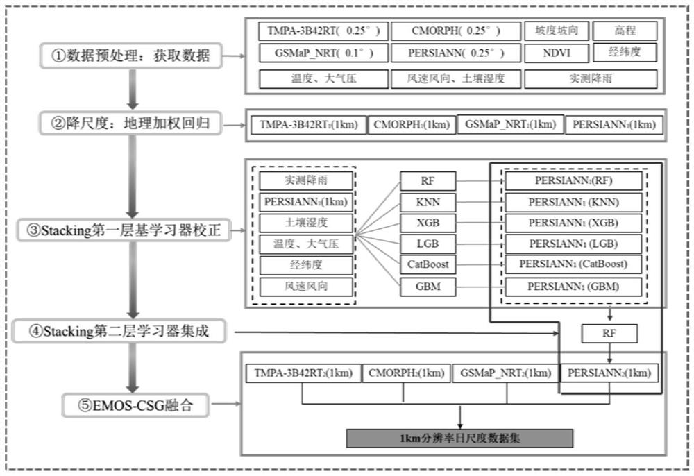
[0045] The present invention will be further described below in conjunction with the accompanying drawings and specific examples. The following examples are only used to illustrate the technical solution of the present invention more clearly, but not to limit the protection scope of the present invention.

[0046] Such as figure 1 as shown,

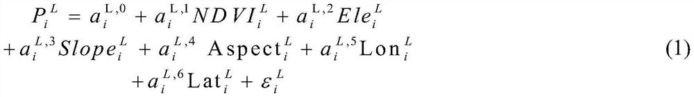
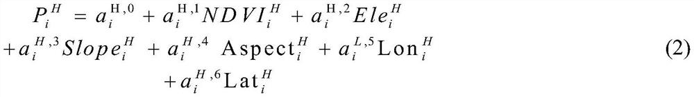
[0047] Step 1. Perform data preprocessing on the target watershed, including obtaining the daily precipitation data of the rainfall station in the watershed, and downloading the precipitation data of four original satellite products of TMPA-3B42RT, CMORPH, GSMaP_NRT and PERSIANN at the same time from the corresponding official website, with spatial resolution The ratios are 0.25°, 0.25°, 0.1° and 0.25° respectively, and are accumulated and superimposed into daily-scale rainfall, and the DEM data are downloaded from the geospatial data cloud website, and the longitude and latitude, elevation, slope and aspect are further extracted using A...


PUM


Abstract

The invention discloses a multi-source satellite rainfall fusion method based on Stacking and EMOS-CSG, and the method comprises the steps: data preprocessing: obtaining rainfall station, original satellite rainfall and auxiliary variable data; downscaling each original satellite product by means of a geographically weighted regression model; a plurality of base learners on the first layer of the Stacking integrated framework are adopted to carry out deviation correction on each downscaling satellite product; integrating the deviation correction results of the downscaling satellite products by using a second-layer learning device of the Stacking integration framework; and based on an EMOS-CSG method, Stacking integration results are fused, and a rainfall fusion product with high temporal-spatial resolution is obtained. According to the method, the advantages of different satellite precipitation products are effectively combined through a Stacking and EMOS-CSG fusion method, the deviation of the satellite products is corrected by means of a machine learning model, the precision of the fusion product is improved, and high-precision precipitation input can be provided for a hydrological model.

Description

technical field [0001] The invention belongs to the technical field of hydrology and meteorology, and in particular relates to a multi-source satellite precipitation fusion method based on Stacking and EMOS-CSG. Background technique [0002] High-precision precipitation data is of great significance to flood forecasting, drought monitoring and water resource management in river basins. There are usually two ways to obtain precipitation data: one is to obtain directly through ground rainfall stations, and the other is to obtain indirectly through remote sensing means (mainly radar and satellite). Both methods have their own advantages and disadvantages. Precipitation stations have high data accuracy and long data series, but often the station density is not high, and it is difficult to accurately reflect the spatial distribution of precipitation; satellite precipitation covers a wide range, but due to the influence of inversion algorithms, cloud properties and sensors, there ...

Claims


Application Information

Patent Timeline
IPC IPC(8): G06V20/00G06V10/80G06V10/766G06K9/62G06N20/20G06T3/40
CPCG06T3/4053G06N20/20G06T2207/10032G06F18/254
Inventor 牟时宇李佳朱艳军张团团胡义明梁忠民
Owner DADU RIVER HYDROPOWER DEV
Why Eureka
Try Eureka