Unstructured road state parameter estimation method and system

A road state and parameter estimation technology, which is applied in the field of intelligent vehicle environment perception, can solve problems such as poor robustness, large parameter estimation error, and plane block strategy that does not consider the actual road conditions, so as to improve extraction accuracy and reduce model estimation Effect of Error, Accuracy on Estimation of Unstructured Road State Parameters

Active Publication Date: 2022-05-31
湖南大学无锡智能控制研究院
View PDF14 Cites 5 Cited by
  • Summary
  • Abstract
  • Description
  • Claims
  • Application Information

AI Technical Summary

Problems solved by technology

[0004] (1) The method based on the depth camera has strict requirements on the lighting conditions, and is greatly affected by the estimated depth of the camera, and has poor robustness in complex environmental conditions;
[0005] (2) The method based on 3D point cloud only relies on spatial geometric information and cannot achieve accurate ground segmentation, and for distant point cloud sparse areas, the parameter estimation error is relatively large;
[0006] (3) The planar block strategy used in the existing road state param

Method used


Image

  • Unstructured road state parameter estimation method and system
  • Unstructured road state parameter estimation method and system
  • Unstructured road state parameter estimation method and system

Examples


Embodiment Construction

[0085] The present invention will be described in detail below in conjunction with the accompanying drawings and embodiments.

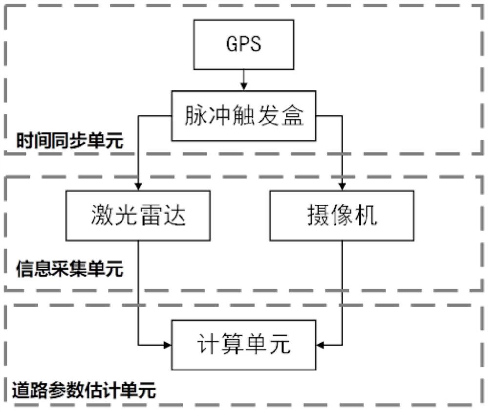
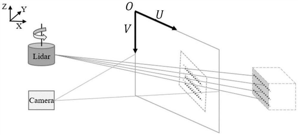
[0087] Step 1, time synchronization and space synchronization are performed on the point cloud data collected and the image data. Of which: number of point clouds

[0092]

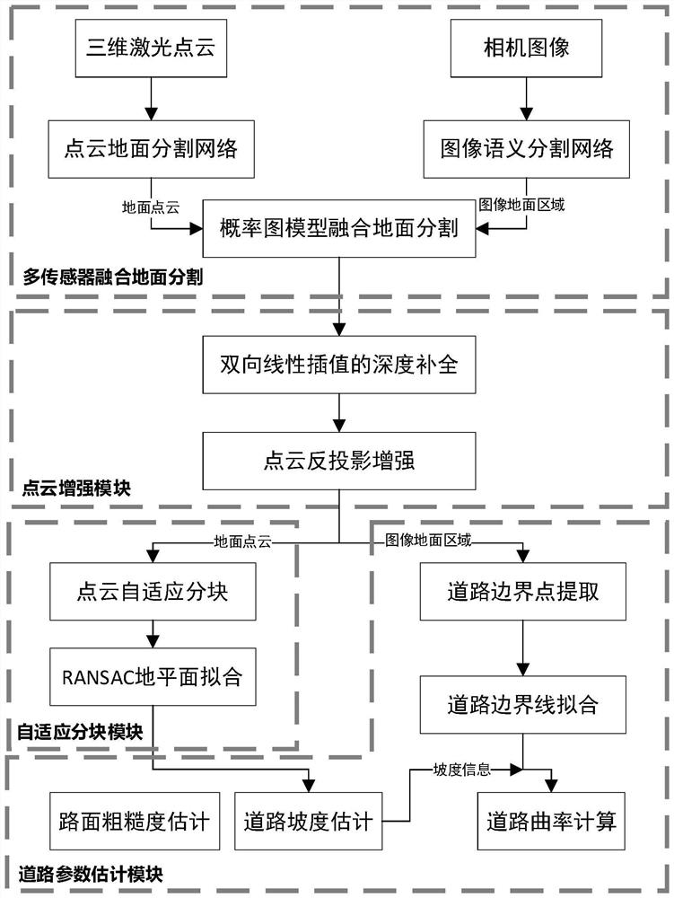
[0097] In step 23, the obtained sum is modeled using a probabilistic graphical model.

[0100] Also consider each pixel in as a node, and these nodes will be referred to as pixel nodes in the text

[0101] Obviously, a node corresponds to only one node probability value.

[0104] Situation 1: When the pixel node c

[0105] Case 2: When the pixel node c

[0109]

[0110]

[0112]

[0120]

[0121]

[0122]

[0124]

[0136]

[0137] In the formula, D represents the initial sampling set, and p( ) represents the probability distribution function.

[0143]

[0144] In the formula, m∈{1,2,...,M},represents the index value of the sample,n∈{1,2,...,N-1},represents the value of each sample

...


PUM


Abstract

The invention discloses an unstructured road state parameter estimation method and system, and the method comprises the steps: 1, carrying out the time synchronization and space synchronization of collected point cloud data and image data, and obtaining a mapping relation between a point cloud in the point cloud data in a laser radar coordinate system and a pixel in a pixel coordinate system; 2, performing multi-sensor fusion ground segmentation, and outputting a point cloud ground segmentation result and an image ground segmentation result; step 3, enhancing ground point cloud data; 4, road adaptive block fitting is carried out, and road surface modeling is realized; step 5, estimating road parameters: based on a pavement plane model, calculating a normal vector included angle of two adjacent planes to obtain relative longitudinal/transverse gradients of the adjacent planes; the distance between the ground point cloud and the corresponding fitting plane is calculated, and the root mean square of the distance is used as an evaluation index of the pavement roughness; and performing road curvature estimation by fitting the road boundary of each block plane.

Description

A method and system for estimating state parameters of unstructured road technical field The present invention relates to the technical field of intelligent vehicle environment perception, especially about a kind of unstructured road state parameter Estimation methods and systems. Background technique Automotive intelligence is an important trend in the development of the automotive industry, and environmental perception technology is the core technology of intelligent vehicle technology. one of the techniques. Environmental perception technology provides environmental information for decision-making, control and other technologies by acquiring and analyzing sensor data. Of course However, when driving on unstructured roads such as mining areas and off-road scenarios, intelligent vehicles need to face the changing road types and increasing slopes. This will undoubtedly bring great challenges to the motion control and safe driving of intelligent vehicles. Therefore...

Claims


Application Information

Patent Timeline
IPC IPC(8): G06T7/10G06T5/50
CPCG06T7/10G06T5/50G06T2207/10028G06T2207/30236
Inventor 谢国涛陈涵周岩秦兆博秦晓辉王晓伟秦洪懋胡满江徐彪边有钢杨泽宇丁荣军
Owner 湖南大学无锡智能控制研究院
Why Eureka
Try Eureka