Image processing method and system in highway technical condition evaluation system

A technology of technical status and image processing, applied in the field of image processing, can solve the problems of omission of disease area identification, human error, huge image data, etc., to achieve the effect of scientific and reasonable logic, avoid misjudgment, and simplify complexity

Pending Publication Date: 2022-07-15
HUNAN ZHONGDA CONSTR ENG TESTING TECH
View PDF0 Cites 0 Cited by
  • Summary
  • Abstract
  • Description
  • Claims
  • Application Information

AI Technical Summary

Problems solved by technology

However, in the actual operation process, due to the limitation of image resolution and the ability to distinguish with the naked eye, manual identification of diseased areas can easily lead to more omissions.
At the same time, since there are many types of diseases corresponding to various pavement materi

Method used


Image

  • Image processing method and system in highway technical condition evaluation system

Examples


Example Embodiment

[0023] Example 1

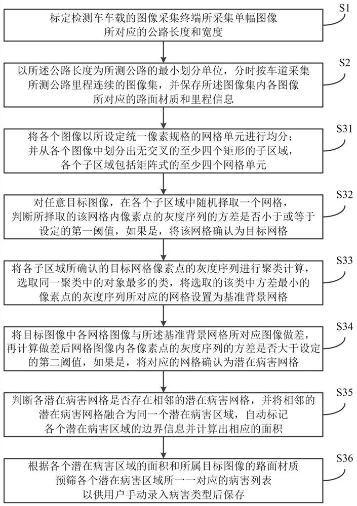
[0024] This embodiment discloses an image processing method in a highway technical condition assessment system, which is mainly applied to the detection of road surface diseases, especially suitable for road markings (for example: left turn, right turn, straight, lane dividing line, etc.) Road inspection prior to laying pavement markings and speed bumps. The main purpose of the method mainly includes: collecting continuous image sets of measured highway mileage by lane in time-sharing; determining the corresponding reference background grids for each target image; , and then calculate whether the variance of the grayscale sequence of each pixel in the grid image after the difference is greater than the set second threshold, if so, confirm the corresponding grid as a potential disease grid; The grids are merged into the same potential disease area, the boundary information of each potential disease area is automatically marked and the corresponding area is c...

Example Embodiment

[0048] Example 2

[0049] Corresponding to the above method embodiments, the present embodiment discloses an image processing system in a highway technical condition assessment system, including a memory, a processor, and a computer program stored in the memory and running on the processor, wherein the When the processor executes the computer program, the steps corresponding to the above method embodiments are implemented.

[0050] To sum up, the image processing method and system in the highway technical condition assessment system disclosed by the above embodiments of the present invention at least have the following beneficial effects:

[0051] In a large number of statistical data, the area occupied by the diseased area in the collected images is usually much smaller than the normal area, and in the image set with continuous measured highway mileage, the image with the disease is compared with the normal image without the disease. , is also a small probability event. The...


PUM


Abstract

The invention relates to the technical field of image processing, and discloses an image processing method and system in a highway technical condition evaluation system so as to improve efficiency and reliability. The method comprises the following steps: acquiring continuous image sets of measured highway mileages according to lanes in a time-sharing manner; determining a corresponding reference background grid for each target image; performing subtraction on each grid image in the target image and an image corresponding to the reference background grid, then calculating whether the variance of the gray sequence of each pixel point in the grid image after subtraction is greater than a set second threshold value, and if yes, determining the corresponding grid as a potential disease grid; fusing adjacent potential disease grids into the same potential disease area, automatically marking boundary information of each potential disease area, and calculating a corresponding area; and according to the area of each potential disease area and the pavement material of the target image, pre-screening a disease list corresponding to each potential disease area in a one-to-one manner for a user to manually input a disease type and then store the disease type.

Description

technical field [0001] The invention relates to the technical field of image processing, in particular to an image processing method and system in a highway technical condition assessment system. Background technique [0002] In the daily maintenance of highways, it is usually necessary to carry out technical condition assessment every year. In the existing road detection, the image data of road conditions is usually collected by the detection vehicle, and then the user visually demarcates the disease area and marks the disease type of the disease area. However, in the actual operation process, due to the limitation of image resolution and the ability of the naked eye to distinguish, manual identification of the diseased area is likely to lead to more omissions. At the same time, since there are many types of diseases corresponding to various pavement materials, and the same diseases are also classified as mild, moderate and severe; in the existing road detection, due to th...

Claims


Application Information

Patent Timeline
IPC IPC(8): G06T7/00G06T7/13G06T7/62
CPCG06T7/0006G06T7/13G06T7/62G06T2207/20021G06T2207/30132
Inventor 王朝扣陈跃欣刘泽亮
Owner HUNAN ZHONGDA CONSTR ENG TESTING TECH
Why Eureka
Try Eureka