Long-time-sequence territorial space function and structure simulation method

A simulation method and function technology, applied in the field of long-term territorial space function and structure simulation, which can solve problems such as uncertainty, decoupling of natural carrying capacity and future spatial governance trends, and parameter errors of functional land.

Active Publication Date: 2022-08-05
INST OF GEOGRAPHICAL SCI & NATURAL RESOURCE RES CAS
View PDF9 Cites 3 Cited by
  • Summary
  • Abstract
  • Description
  • Claims
  • Application Information

AI Technical Summary

Problems solved by technology

[0005] The technical problem to be solved by the present invention is: Aiming at the problems of functional land use parameter errors and uncertainties existing in previous land space function and structure simulations, and decoupling from natural carrying capacity and future spatial governance trends, relying on the geographic information big data platform Google Earth Engine (GEE), proposed a long-term land space function and structure simulation method to ensure the consistency of time-space changes in long-term land space function and structure, and improve the accuracy of space simulation

Method used


Image

  • Long-time-sequence territorial space function and structure simulation method
  • Long-time-sequence territorial space function and structure simulation method
  • Long-time-sequence territorial space function and structure simulation method

Examples


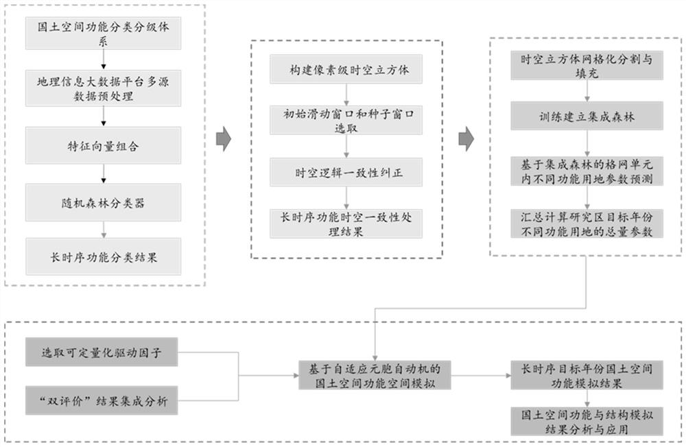
Embodiment Construction

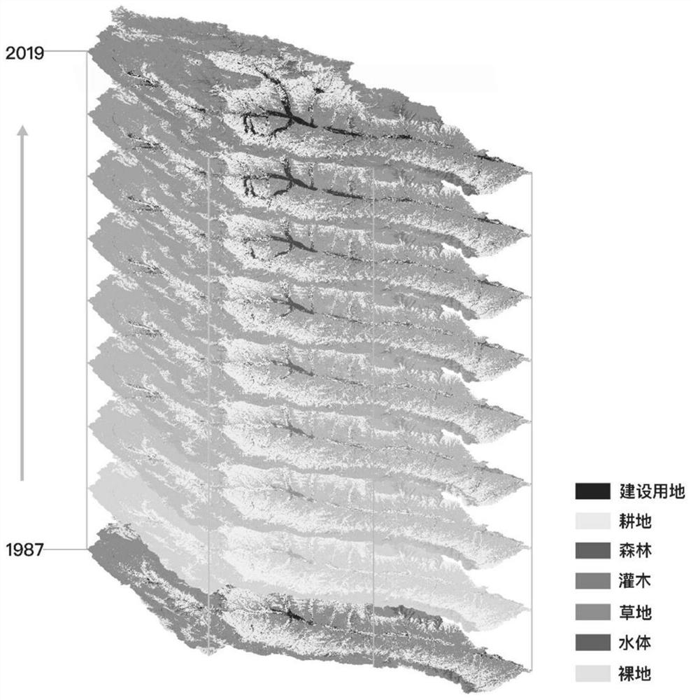
[0027] The experimental data used in this experiment include: Landsat series images for 32 years from 1987 to 2019, surface reflectance products, 30m resolution; VIIRS nighttime light data (Nighttime Day / Night Band CompositesVersion 1), 500m resolution; digital elevation data ( SRTM), 30m resolution; administrative division data of townships and administrative villages in 2020.

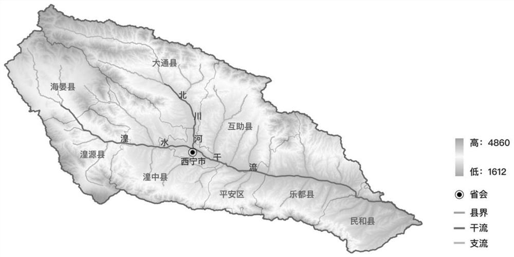
[0028] The study area selects the Huangshui River Basin in Qinghai Province, located at 36°02′~37°28′N, 100°42′~103°04′E, with a drainage area of ​​about 16200km 2 . like figure 1 shown. Combining the main stream area of ​​Huangshui River and the tributary Datong River Basin, it involves three prefecture-level administrative areas of Xining City, Haidong City and Haibei Prefecture, including Chengzhong District, Chengdong District, Chengxi District, Chengbei District, Huangyuan County, and Huangzhong District of Xining City , Datong County, Ledu District, Ping'an District, Minhe County, Huzhu Count...


PUM


Abstract

The invention relates to a long-time-sequence territorial space function and structure simulation method, which comprises the following steps of: firstly, carrying out territorial space function initial classification on a long-time-sequence image by adopting a random forest algorithm based on a geographic information big data platform Google Earth Engine (GEE) platform; secondly, constructing a pixel-level space-time cube, performing space-time consistency function correction, and on the basis of space-time cube segmentation and filling, utilizing an integrated forest algorithm to simulate different functional land use amount parameters of each target year in a long time sequence; and finally, deriving spatial transformation rules and spatial constraints of land with different functions according to a'double evaluation 'result, and performing simulation analysis on the land space function and structure of the target year by utilizing an adaptive cellular automaton. The method improves the recognition and simulation precision of the territorial space function and structure, is suitable for recognition and simulation of the territorial space function and structure with a long time sequence, high density and a large range, and is especially suitable for auxiliary decision making of territorial space planning and space governance.

Description

technical field [0001] The invention relates to a long-term land space function and structure simulation method supported by a geographic information big data platform Google Earth Engine (GEE), in particular to a long-term land space function and structure based on space-time cube segmentation and integrated forest algorithm mock method. Background technique [0002] The function of territorial space refers to the comprehensive functions and objective roles performed by a certain region in the natural resource and ecological environment system, and in the human production and living system within a larger geographical scope. Different from the land use function, the land space function is a comprehensive and integrated research on the use of the surface by humans and the protection function of the natural ecosystem on the surface under the guidance of the regional system theory of the relationship between man and land, and promotes development through the optimization of th...

Claims


Application Information

Patent Timeline
Patent Type & Authority Applications(China)
IPC IPC(8): G06F30/13G06F111/20
CPCG06F30/13G06F2111/20Y02A90/10
Inventor 王亚飞
Owner INST OF GEOGRAPHICAL SCI & NATURAL RESOURCE RES CAS
Why Eureka
Try Eureka