Improved positioning and data integrating method and system thereof

A global positioning system and data technology, applied in positioning, radio wave measurement system, navigation, etc., can solve the problems of expensive inertial navigation system, increased position error, and drift effects, and achieve high precision, low power consumption, and low cost Effect

Inactive Publication Date: 2002-10-02
林清芳
View PDF1 Cites 33 Cited by
  • Summary
  • Abstract
  • Description
  • Claims
  • Application Information

AI Technical Summary

Problems solved by technology

However, an inertial navigation system is expensive and is subject to drift ov

Method used


Image

  • Improved positioning and data integrating method and system thereof
  • Improved positioning and data integrating method and system thereof
  • Improved positioning and data integrating method and system thereof

Examples


Embodiment Construction

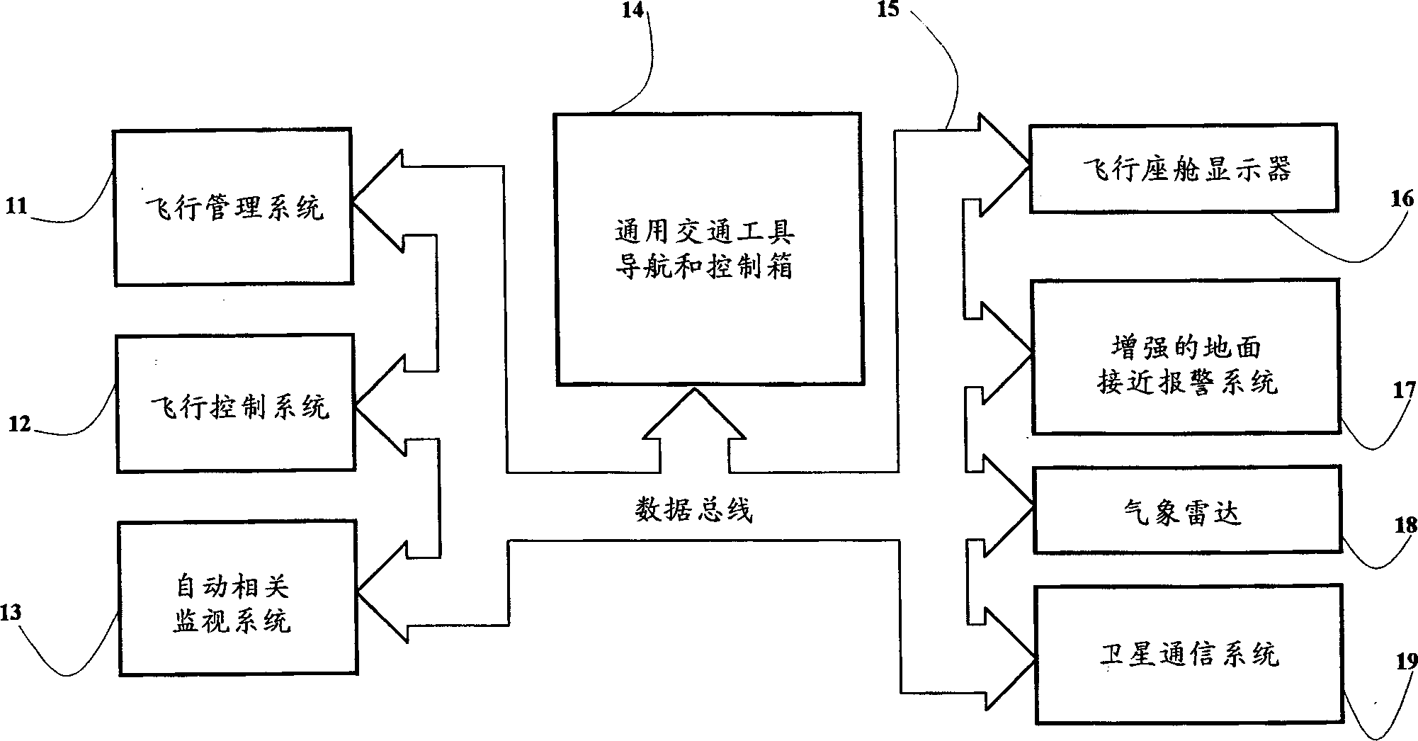
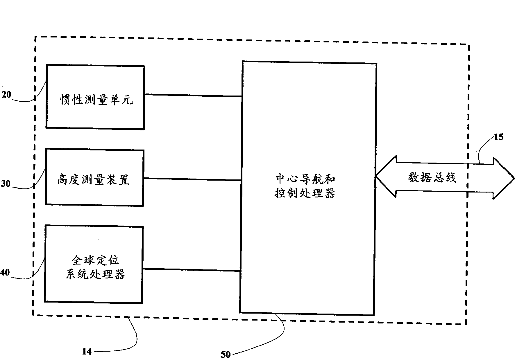
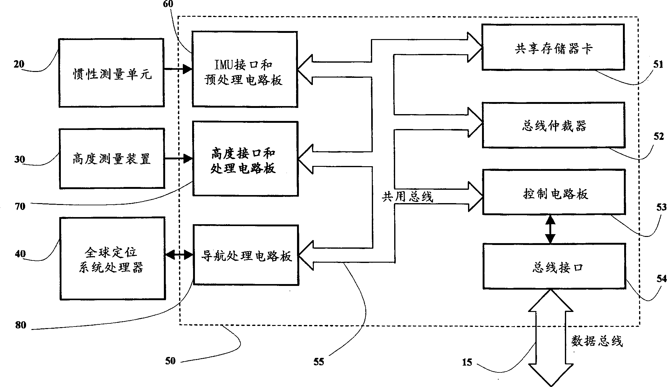
[0057] The present invention provides an improved general positioning and data integration method and system in which a control board manages the navigation data and inertial sensor data and distributes it to other onboard systems for air, ground and water vehicles .

[0058] The method and system of the present invention can be used in handheld applications where a control board manages the navigation data and inertial sensor data and distributes the navigation data and inertial sensor data to a display device and wireless communication device.

[0059] The method and system of the present invention are used with a Global Positioning System / Inertial Measurement Unit (GPS / IMU) integrated navigation system in which the following means are integrated with the GPS / IMU integrated navigation system to enhance the positioning solution and control performance in order to suit various applications: altimeter, north determination, velocity generator, geographic database and an interfac...


PUM


Abstract

An improved positioning and data integrated processing method and system can substantially solve the problems encountered in the system integration of personal handheld applications, air, ground and water vehicles, an integrated GPS/inertial measurement unit consists of optional enhanced by other means to obtain user position, velocity, attitude, and airframe acceleration and rotation information and to distribute these data to other onboard systems, such as flight management systems, flight control systems, automatic dependent surveillance systems in the case of aircraft applications , cockpit displays, enhanced ground proximity warning system, weather radar and satellite communications system.

Description

technical field [0001] The present invention relates to positioning and data integration methods and systems, and more particularly to an improved positioning and data integration method and system for personal handhelds such as air, ground, and water vehicles, which employs an integrated global positioning system / inertial measurement unit , with the optional assistance of other navigation devices, obtain the vehicle's position, velocity, attitude, and body acceleration and rotation information, and disseminate these data to other systems onboard the vehicle, such as in the case of aircraft applications , disseminate these data to the flight management system, flight control system, automatic dependent surveillance system, cockpit display system, enhanced ground approach alarm system, weather radar, and satellite communication system. Background technique [0002] Increasing complexity is a common challenge in the comprehensive design of positioning and data integration meth...

Claims


Application Information

Patent Timeline
IPC IPC(8): G01C21/00G01S5/00
Inventor 林清芳
Owner 林清芳
Why Eureka
Try Eureka