Method for correcting navigation positioning data

A technology of navigation positioning and correction methods, which is applied in the field of navigation systems, can solve problems such as immaturity and systematization, weak adaptability to complex working environments, and relatively subjective factors in information description, so as to improve quality and real-time processing Ability to judge the effect of reliable results

Active Publication Date: 2007-01-03
SOUTH CHINA AGRI UNIV
View PDF0 Cites 37 Cited by
  • Summary
  • Abstract
  • Description
  • Claims
  • Application Information

AI Technical Summary

Problems solved by technology

At present, the research on multi-sensor combined navigation and positioning methods has formed a new research field, that is, the fusion of multi-sensor positioning data. The known methods can be roughly divided into two categories: one is the method of using probability and statistics, including estimation theory, Kalman filter, Bayes method, statistical decision-making and other improved methods. Although the probability and statistics method has become an indispensable tool in the fusion of multi-sensor positioning data, due to the defects of the probability theory itself, it is often necessary to do some work when using this type of method. Clear assumptions, and ensure that the pre-test parameters are not distorted and the system modeling is accurate. Therefore, many probability and statistics methods are based on a certain probability distribution, and their adaptability to dynamic and uncertain complex working environments is weak
The second is the use of artificial intelligence methods, including D-S evidence reasoning, fuzzy logic, production rules, artificial neural networks, etc., artificial intelligence methods overcome the problems faced by probability and statistics methods to a certain extent. It is closer to the human way of thinking, with good adaptability and robustness, but it is not yet mature and systematic, and there are relatively subjective factors in the description of information
In a word, in the known methods, each method has its own advantages and limitations, and there is no general method that can be used to deal with the multi-sensor combined positioning problem in all situations.

Method used


Image

  • Method for correcting navigation positioning data
  • Method for correcting navigation positioning data
  • Method for correcting navigation positioning data

Examples


Embodiment Construction

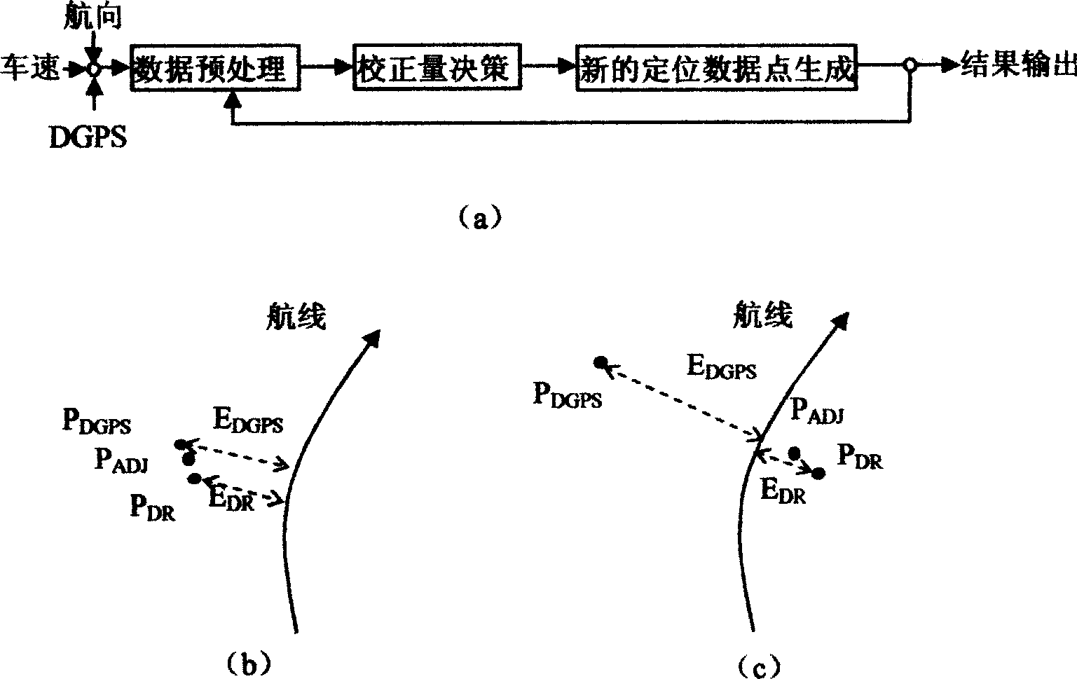
[0027] figure 1 It is a schematic diagram of the principle of the embodiment when correcting the input of two positioning data points obtained by DGPS and DR. In this embodiment, the main parameters of the projected coordinate system used for electronic map registration are:

[0028] (1) Projection method: Gauss-Kruger

[0029] (2) Central meridian: 114.000000 (3 degree belt)

[0030] (3) Horizontal offset: 500km

[0031](4) Geographic coordinate system: GCS_WGS_1984

[0032] (5) Geodetic reference system: D_WGS_1984

[0033] (6) Reference ellipsoid: WGS_1984

[0034] (7) Major axis of ellipsoid: 6378137m

[0035] (8) Ellipsoid oblateness: 0.0033528107.

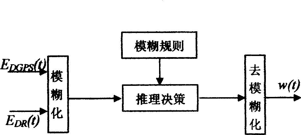
[0036] figure 1 a for figure 1 A schematic diagram of the process of performing the correction process in the illustrated embodiment. In an ideal state, DGPS and DR positioning data point P DGPS ,P DR are coincident together, but due to the existence of errors, these two positioning data points usually do not c...


PUM


Abstract

The invention is concerned with the navigation system and the emendation method of the navigation orientation data, in order to conquer the shortage of the existing technology, provide a emendation method that can emendate the navigation orientation data accurately especially fit for farmland busywork. The invention is: the map registration provides the more accurate electronic map to the system, compares the orientation data point of every sensor and the known skyway that prearranges to be track, and then processes general estimation, works out emendation data point with higher reliability. The invention is consists of four processes namely the map registration, the sensor data prearrangement, the emendation value decision-making, the new orientation data point creating.

Description

technical field [0001] The invention relates to a navigation system, in particular to a method for correcting navigation and positioning data, and its scope of application covers occasions where a machine is guided to track a predetermined route in a known environment to realize autonomous walking. Background technique [0002] In precision agricultural operations, in order to realize the automatic collection of positioning prescription farming and agricultural information, an intelligent operation platform that can move autonomously is needed. and other operations, and must be able to walk in the field according to the pre-planned path, accurately reach the destination and complete the established tasks. To realize the autonomous walking of the agricultural intelligent mobile platform, precise navigation is one of the key technologies. The accuracy of navigation and positioning directly affects the quality of automatic route tracking of agricultural intelligent mobile plat...

Claims


Application Information

Patent Timeline
Patent Type & Authority Applications(China)
IPC IPC(8): G01C21/00G01C21/20G01C21/28G01S5/02G01S1/02G01S15/08G01S17/08G01S19/07
Inventor 罗锡文周志艳张智刚
Owner SOUTH CHINA AGRI UNIV
Why Eureka
Try Eureka