Self adaptive weighting feedback correcting filter method of SINS/GPS combined navigation system

An integrated navigation system and self-adaptive weighting technology, which is applied to navigation through speed/acceleration measurement, navigation calculation tools, road network navigators, etc., can solve the problem of low accuracy of estimated values, decreased accuracy of integrated navigation systems, and small observability And other issues

Inactive Publication Date: 2007-04-11
BEIHANG UNIV
View PDF0 Cites 29 Cited by
  • Summary
  • Abstract
  • Description
  • Claims
  • Application Information

AI Technical Summary

Problems solved by technology

However, since the SINS/GPS integrated navigation system is usually not fully observable, the observability of some state variables is very small, resulting in low accuracy of the estimated values ​​of t

Method used


Image

  • Self adaptive weighting feedback correcting filter method of SINS/GPS combined navigation system
  • Self adaptive weighting feedback correcting filter method of SINS/GPS combined navigation system
  • Self adaptive weighting feedback correcting filter method of SINS/GPS combined navigation system

Examples


Embodiment Construction

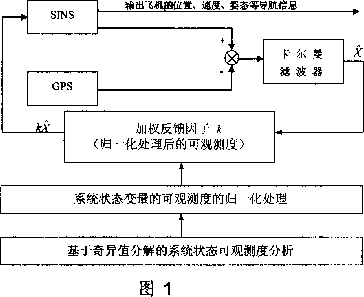
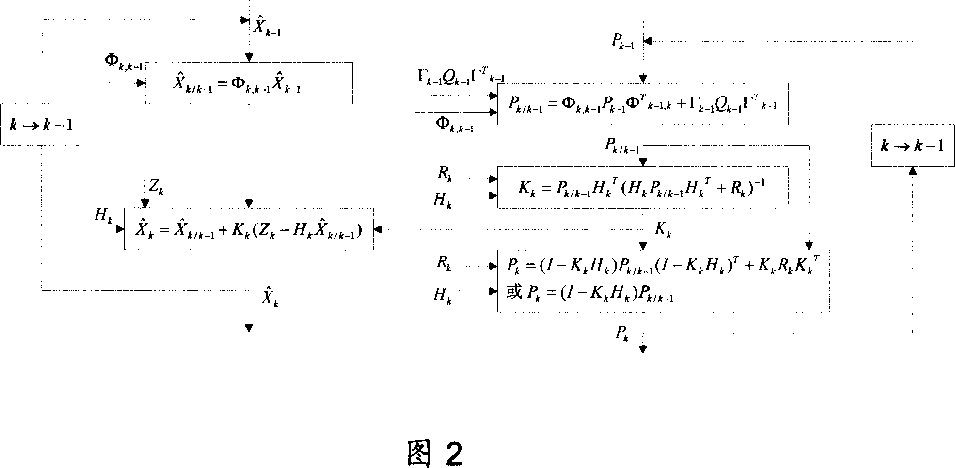
[0035] As shown in Figures 1 and 2, the specific implementation method of the present invention is as follows:

[0036] (1) Establish the mathematical model of the SINS / GPS integrated navigation system, including the system state equation and measurement equation, as shown in formula 1 and formula 2 respectively.

[0037] System state equation:

[0038] X · = FX + GW - - - ( 1 )

[0039] Among them, X is the system state vector, W is the system noise vector, F is the system transfer matrix, and G is the noise transfer matrix:

[0040] X=[φ x φ y φ z δv x δv y δv z δL δλ δh ε x ε y ε z  x  y  z ] T

[0041]

[0042] F = F INS F ...


PUM


Abstract

The present invention relates to adaptive weighting feedback correcting and filtering method for combined SINS/GPS navigation system. The method includes the first utilizing observed position and speed quantities the GPS provides in Kalman filtering to estimate the SINS position error, speed error, attitude error and device error; and the subsequent calculating the measurability of the system state quantities in the system measurability analysis process and adaptive weighting feedback correction on the SINS with the normalized system measurability as the weighting feedback factor. The present invention has the advantages of high precision, less divergence and high navigation precision on airplane, missile, ship and ground vehicle.

Description

technical field [0001] The invention relates to a filtering method for information fusion of a SINS / GPS integrated navigation system, which can be used to improve the navigation accuracy of the SINS / GPS integrated navigation system used for aircraft, missiles, ships or ground vehicles. Background technique [0002] Strapdown Inertial Navigation System (SINS) is a completely autonomous navigation system that can provide position, velocity and attitude information continuously and in real time. It has high short-term accuracy, good concealment, and is not limited by weather conditions. , and thus widely used in aviation, aerospace, navigation and other fields. However, the SINS error increases with time, so it is often combined with the Global Positioning System (GPS) to form a SINS / GPS integrated navigation system. [0003] In the SINS / GPS integrated navigation system, in order to improve the accuracy of the integrated navigation system, the existing methods often use the fe...

Claims


Application Information

Patent Timeline
IPC IPC(8): G01C21/26G01C21/28G01C21/20G01C21/16G01S1/02G01S5/02G01S5/14G01S19/49
Inventor 房建成刘百奇杨胜宫晓琳张钰李金涛
Owner BEIHANG UNIV
Why Eureka
Try Eureka