Airborne imaging spectrometry system and method

a spectrometry system and spectrometry technology, applied in the field of airborne imaging spectrometry system and method, can solve the problems of lack of bandwidth, time-consuming and laborious to gather spectral data and final analysis of such data, and achieve the effect of time-critical decision making

Inactive Publication Date: 2005-05-19
SPECTROTECH
View PDF14 Cites 56 Cited by
  • Summary
  • Abstract
  • Description
  • Claims
  • Application Information

AI Technical Summary

Benefits of technology

[0031] The present invention also relates to an airborne hyperspectral imaging spectrometry system. The system comprises an airborne digital hyperspectral imaging spectrometer that is operative to scan an area of interest and collect hyperspectral imagery of that area of interest. The system further includes a display that is operative to display the hyperspectral imagery of the area of interest in real-time. The system also includes a controller that is operative to create a snapshot of the hyperspectral imagery of the area of interest. This controller is also able to save the snapshot and geo-locate the snapshot.

Problems solved by technology

The hyperspectral images produced by commercially available hyperspectral imaging spectrometers generally provide the fine spectral resolution needed to characterize the spectral properties of ground surface material; however, the volume of data in a single hyperspectral image may seem overwhelming to a user.
However, the time between gathering the spectral data and the final analysis of such data may be quite lengthy because of the high volume of spectral data collected and / or because of limitations of the technology available for transmitting and analyzing such spectral data (limitations such as a lack of bandwidth for transmitting spectral data from an aircraft to a remote location).
However, because geological structures encounter virtually no change within the time frame of this spectral analysis, time has not been a critical parameter in such geological applications.
Because urban growth and its effects on the environment are slow processes, the large amount of time between the gathering of the spectral data and the analysis of such data has not been of importance.
Yet, like several applications described above, it has not been a critical factor in such forestry applications that the amount of time required between gathering spectral data and analyzing such data (before the data is useful in forestry decision making) can be quite large.
Yet, the spectrometer disclosed by the U.S. Pat. Nos. 5,149,959 and 5,276,321 patents is not designed to collect, process, and transmit, in “near real-time,” spectral imagery and data that is useful immediately in time-sensitive or time-critical decision making.
Each year, millions of acres of forests are destroyed in forest fires.
However, one problem with such an approach is that only a visual observation is conducted, which may or may not correctly identify the most critical burn areas of the forest fire.
But for such satellite photography to be processed into useful information for forest firefighters, typically a large amount of time (e.g., 12 hours or more in certain situations) is required.
Additionally, the destruction of forests by insects presents a significant economic problem to the lumber industry, wood products industry, and the pulp and paper industry, and often such infestations are time-sensitive or time-critical.
However, when using currently available airborne spectrometers in such situations, acquiring the necessary spectral data and converting this data into spectral signature profiles for the vegetation is a lengthy process.
During the time needed for data conversion and analysis, additional trees may become distressed.
Such a study showed that a small boat could leave a very large thermal footprint.
However, using a known digital airborne imaging scanner to collect this thermal data requires a significant amount of time for converting the data to usable information for drug interdiction.
In addition, the sensitivity of certain scanners (e.g., the signal to noise ratio) may not be adequate for profiling spectral signatures in order to distinguish the propeller wash of different types of boats.

Method used


Image

  • Airborne imaging spectrometry system and method
  • Airborne imaging spectrometry system and method
  • Airborne imaging spectrometry system and method

Examples


example 1

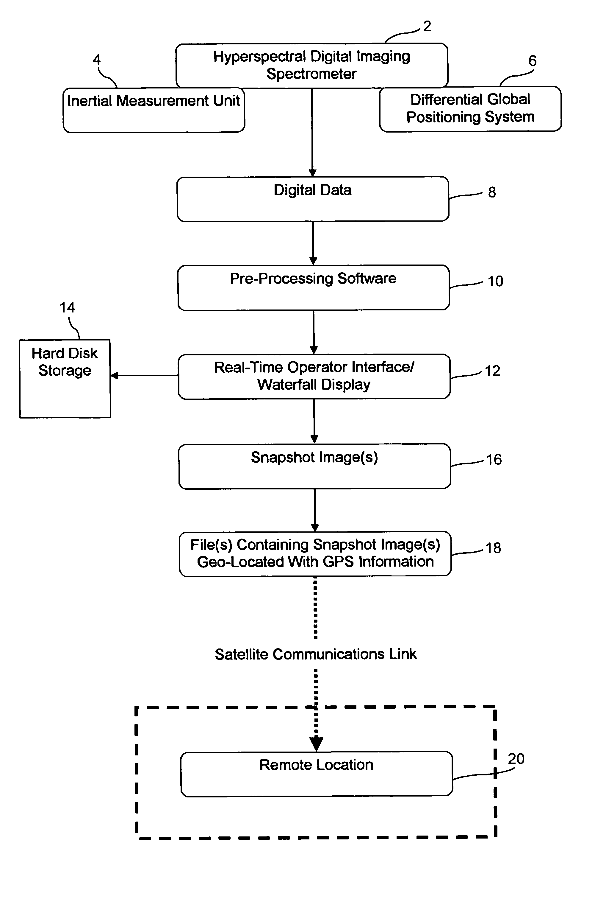
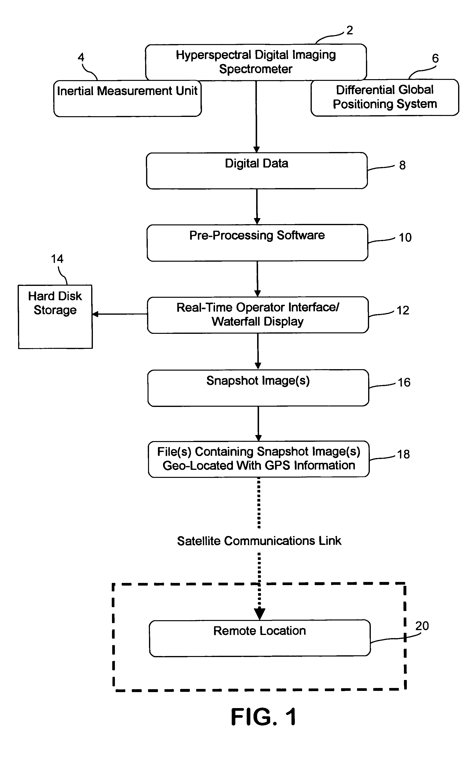
[0078] In this Example, a system according to the present invention was tested to demonstrate the ability of the system to collect hyperspectral imagery and related data during an airborne mission and transmit that imagery and data from the aircraft to a ground receiving station in near-real time. More specifically, the goal of this Example was to demonstrate this near real-time transmission of hyperspectral imagery and data in less than 15 minutes from the time the imagery and related data were collected aboard the aircraft to the time the imagery and data were received at the ground receiving station.

[0079] The area of interest in Example 1 was an area in a national forest where the U.S. Forestry Service was conducting controlled burns. Thus, the time-sensitive or time-critical decision making involved in Example 1 included making decisions in a forest firefighting application.

[0080] The aircraft in which the digital hyperspectral imaging spectrometer was mounted was a U.S. Fore...

example 2

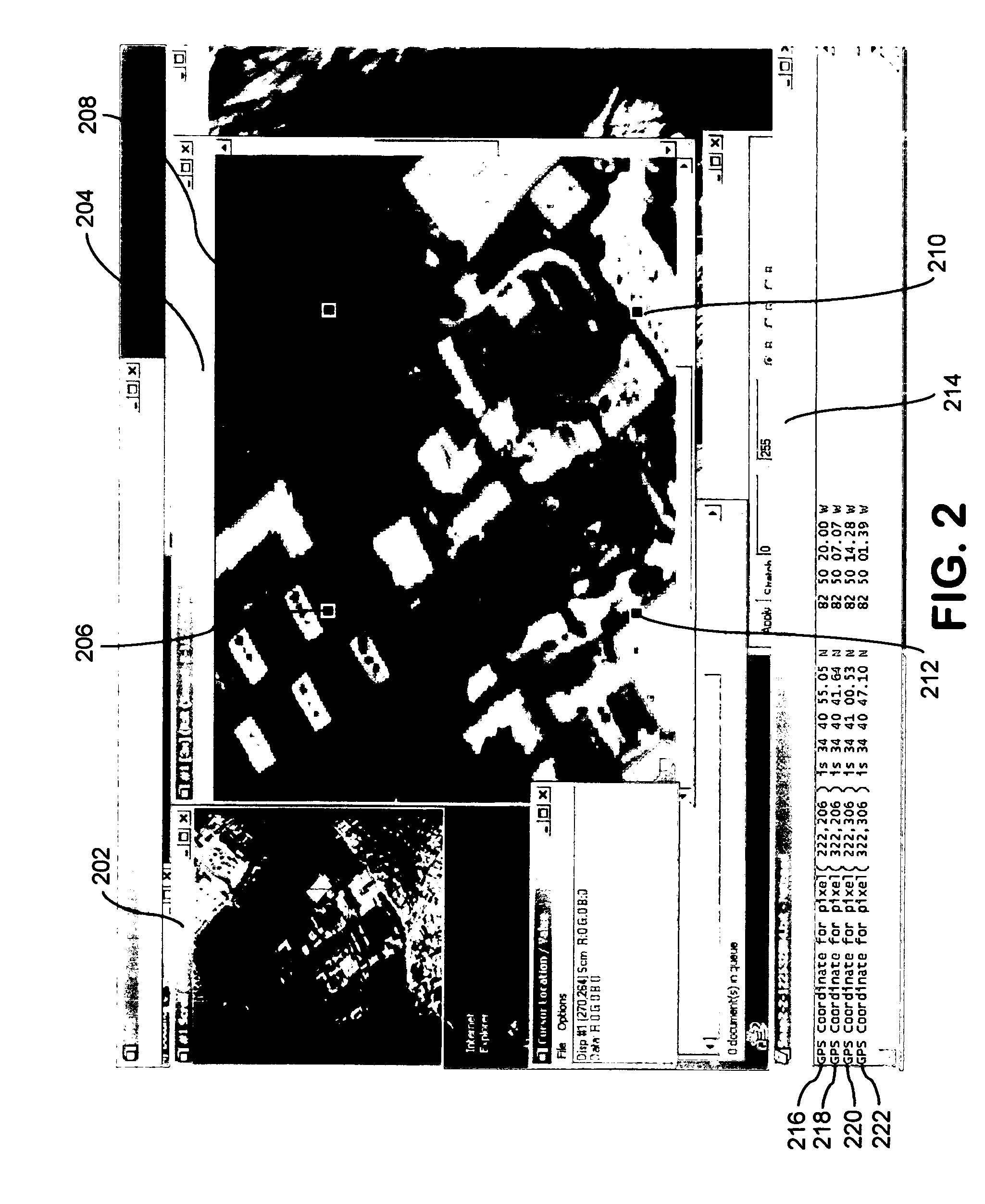
[0107] In this Example, another airborne mission took place one day after the test flights conducted and described in Example 1 above. Specifically, the test flights in this Example continued for about 1.5 hours, and the same equipment, flight procedures, and methods from Example 1 were used, with the following exceptions: (1) additional liquid nitrogen was provided aboard the aircraft for further cooling of the thermal detectors on the DAIS 3715 spectrometer; (2) a calibration flight was conducted upon departure from the airport area rather than upon return; and (3) the procedures and hardware for installing the DAIS 3715 spectrometer in the aircraft were slightly modified to result in a more secure mounting system in the aircraft. The weather conditions during the test flights of Example 2 were favorable.

[0108] The quality of the hyperspectral imagery collected and transmitted during the test flights of Example 2 was excellent and was higher than the quality of some of the imager...


PUM


Abstract

The present invention generally relates to an airborne imaging spectrometry method and system. According to the present invention, a digital airborne imaging spectrometer is provided aboard an aircraft and is used to collect hyperspectral imagery of an area of interest while the aircraft flies over the area of interest. The method and system of the present invention combine (1) real-time display, aboard an aircraft, of the hyperspectral imagery being collected for an area of interest below the aircraft with (2) transmission of such hyperspectral imagery to a remote location, wherein such imagery is received at the remote location in near real-time. When hyperspectral imagery and related data are received from the aircraft at the remote location, the transmitted hyperspectral imagery and related data are useful at the remote location in time-sensitive or time-critical decision making. Forest fires, infestations of vegetation, and law enforcement scenarios such as counter-narcotic operations are examples of situations in which time-sensitive or time-critical decision making may be necessary and in which the airborne imaging spectrometry system and method of the present invention may be used.

Description

CROSS REFERENCE TO RELATED APPLICATIONS [0001] This application claims benefit of U.S. Provisional Patent Application No. 60 / 504,574, filed Sep. 17, 2003, which is incorporated herein in its entirety by reference thereto.BACKGROUND OF THE INVENTION [0002] The present invention relates to a system and method in which a hyperspectral digital airborne imaging spectrometer, aboard an aircraft, collects hyperspectral imagery and related data of an area of interest while flying over that area of interest, wherein the hyperspectral imagery is processed aboard the aircraft and is transmitted to a remote location (such as a ground station) in near real-time for use in time-sensitive or time-critical decision making processes. [0003] Multispectral and hyperspectral digital imaging devices generally record reflected and emitted spectral data through a series of spectral detectors. Multispectral imaging devices typically produce spectral images based on a few relatively broad wavelength bands, ...

Claims


Application Information

Patent Timeline
Patent Type & Authority Applications(United States)
IPC IPC(8): G01J3/28
CPCG01J3/0264G01N2021/1793G01J3/2823
Inventor TERRY, BENJAMIN SCOTTFLANDERS, DAVID R.
Owner SPECTROTECH
Why Eureka
Try Eureka