Centerline and depth locating method for non-metallic buried utility lines

a technology of non-metallic underground utilities and depth locating methods, which is applied in the direction of reradiation, detection using electromagnetic waves, instruments, etc., can solve the problem that the diameter of utility lines is not normally measurabl

Active Publication Date: 2005-07-21
BUSAN TRANSPORTATION CORPORATION
View PDF22 Cites 81 Cited by
  • Summary
  • Abstract
  • Description
  • Claims
  • Application Information

AI Technical Summary

Benefits of technology

[0014] A dual mode line locator is described that combines conventional electromagnetic line locator techniques with ground penetrating radar (GPR), allowing accurate real-time tracking of position and depth for both metallic and non-metallic lines. More specifically a signal processing method is described to allow real-time line tracking in the GPR mode, which relies on range data (echo signals) from the radar system as well as dual-axis accelerometers for inertial tracking purposes. In particular, the preferred embodiment combines the GPR sensor inputs with a signal processing system and display device that emulates the user interface and tracking capabilities of traditional metallic pipe and cable locators. The preferred embodiment allows the visual presentation of signal strength, left / right line deviation, and line guidance in substantially the same visual elements that guide a user during the tracking of metallic lines using electromagnetic methods.
[0015] This disclosed method maps the radar range data, combined with position information from inertial sensors, through a multi-order Kalman filter, enabling a smooth predicted path of the non-metallic line based on measured data and physical models. Though this method can stand alone and be implemented on GPR-only locating systems, the preferred embodiment takes advantage of the dual-mode aspect of the invention and enhances the depth accuracy of GPR systems using electromagnetic (EM) line locator measurements made during calibration.
[0016] The invention also makes use of the EM locator's independent (and quite accurate) depth measurement capability to accurately deduce the radar signal velocity and hence the dielectric constant of the soil in the immediate vicinity of the GPR based non-metallic line locates. Since the radar signal time delay to target is directly proportional to the velocity of propagation of the radar signal in the soil, the present invention leads to better GPR-based location accuracy (both centerline and depth) when the velocity (and hence the radar echo return time) is correctly calibrated by the EM system.

Problems solved by technology

In present GPR systems the diameter of utility lines is not normally measurable, especially when the longer wavelengths necessary for ground penetration to several feet are used.

Method used


Image

  • Centerline and depth locating method for non-metallic buried utility lines
  • Centerline and depth locating method for non-metallic buried utility lines
  • Centerline and depth locating method for non-metallic buried utility lines

Examples


Embodiment Construction

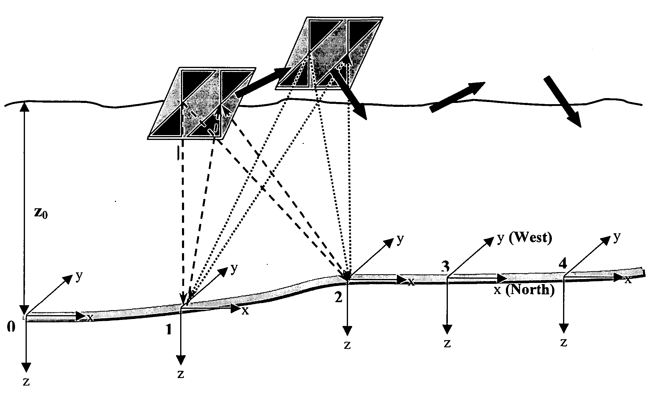
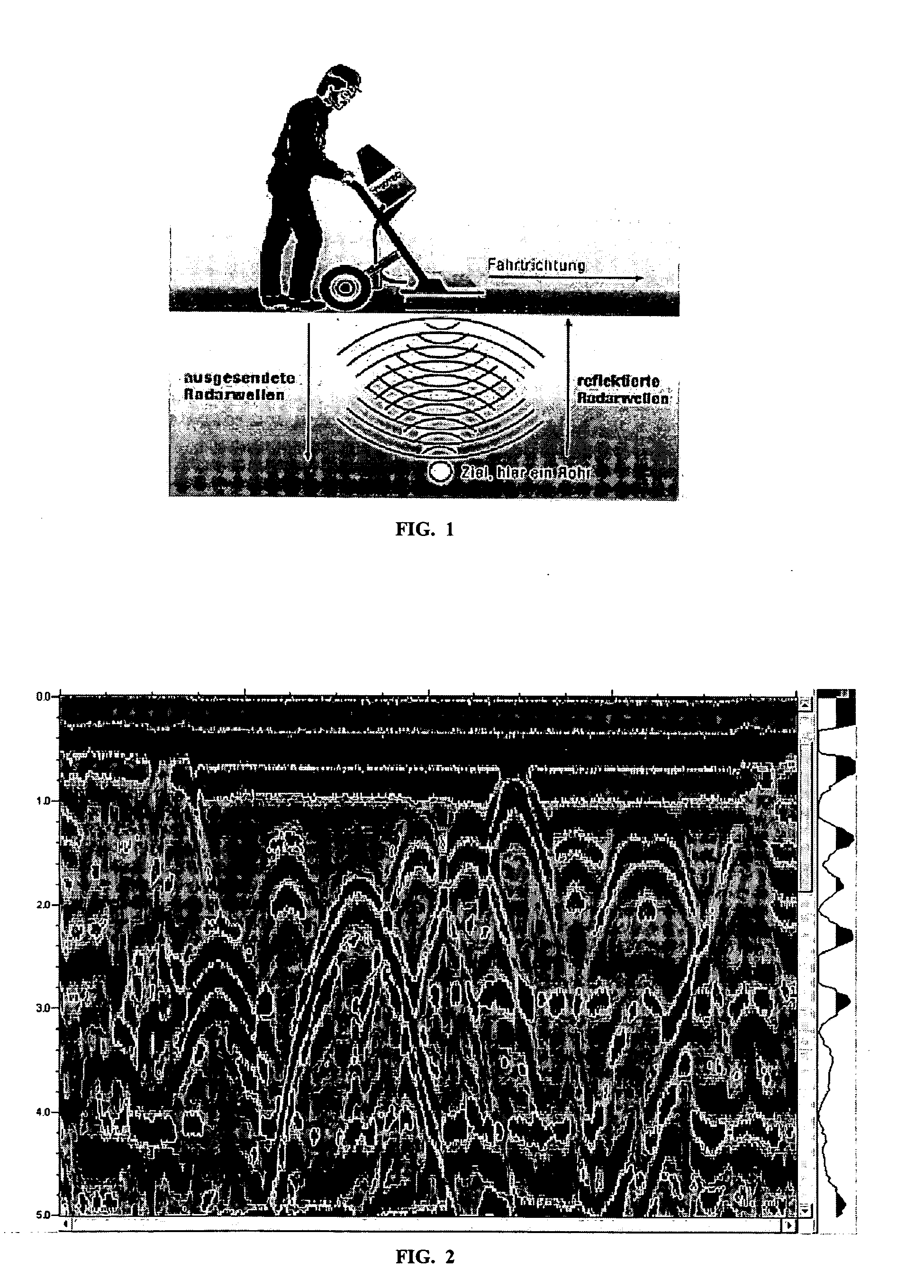
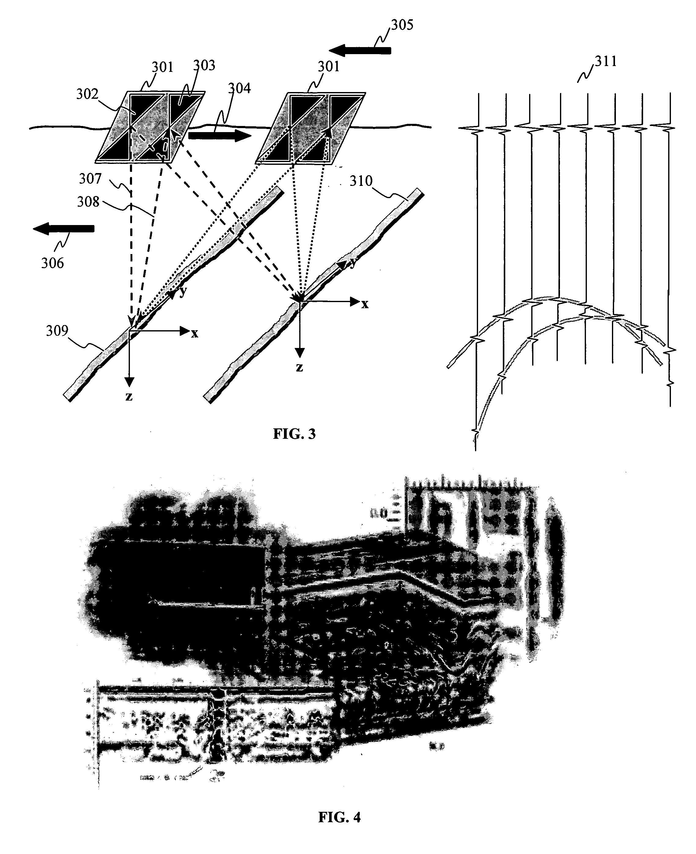
[0028] Line locator 500 in FIG. 5 offers both EM and GPR location methods and thus is a dual mode locator for both metallic and non-metallic utility lines. Out of view of the locate technician operating locator 500 is a buried utility line. If an active EM signal from a transmitter (not shown) has energized the line, the induced magnetic field is essentially concentric and five coils 503 (bottom reference), 505 (left / right, includes two coils), 504 (top), and 506 (guidance) generate received signals that are processed using the methods previously disclosed in U.S. patent application Ser. No. 10 / 622,376, which is herein incorporated by reference in its entirety. Display 501 and speaker 507 alert the user to the signal strength, left / right deviation from centerline, depth to the conducting line, and a preview of any upcoming turns in the line (using a guidance compass display 604, FIG. 6). The depth is calculated by the ratio of signal levels between the top and bottom coils, using an...


PUM


Abstract

A locator capable of tracking buried, non-metallic utility lines (fiber optic, gas, water, waste, conduits) using ground penetrating radar (GPR) and an inertial position sensor is described. In some embodiments, a tracking filter is applied to a hyperbolic trajectory model based on the radar range data to determine a predicted track of the target utility line. After comparison of the predicted track to the measured inertial position, the centerline variance of the tracked line can be deduced. In some embodiments, an electromagnetic pipe and cable locator may also be included. Some embodiments of the invention can include accurate depth calibration and line depth tracking. Further, a display may provide results to a user in a simplified fashion.

Description

RELATED APPLICATIONS [0001] The present application claims priority to U.S. Provisional Application 60 / 525,291, “Centerline and Depth Locating Method for Non-Metallic Buried Utility Lines,” filed on Nov. 25, 2003, by James W. Waite, herein incorporated by reference in its entiretyBACKGROUND [0002] 1. Field of the Invention [0003] Embodiments of the present invention relate to tracking of concealed non-metallic underground utilities using a pipe and cable locator outfitted with ground penetrating radar and an inertial navigation device. [0004] 2. Discussion of Related Art [0005] Utility conduits are often buried underground and not readily accessible. It is often necessary to locate these concealed utility conduits in order to repair and replace them. It is also important to know the location of utility conduits in order to avoid them while excavating an area. Examples of hidden utility conduits include pipelines for gas, sewage, or water and cables for telephone, television or power...

Claims


Application Information

Patent Timeline
Patent Type & Authority Applications(United States)
IPC IPC(8): G01V3/12
CPCG01V3/12Y02A90/30
Inventor WAITE, JAMES W.
Owner BUSAN TRANSPORTATION CORPORATION
Why Eureka
Try Eureka