Methods and Systems for Determining Coordinates of an Underwater Seismic Component in a Reference Frame

a technology of reference frame and seismic component, which is applied in seismology, seismology, instruments, etc., can solve the problems of not providing the actual position of the receiver on the streamer and the source, less than acceptable seismic data, and methods and systems can be expensive, so as to improve the long-term stability of the gyroscope

Active Publication Date: 2009-09-17
WESTERNGECO LLC
View PDF4 Cites 58 Cited by
  • Summary
  • Abstract
  • Description
  • Claims
  • Application Information

AI Technical Summary

Benefits of technology

[0013]In certain embodiments the component of the underwater network is a part of a single streamer and the acoustic ranging is performed between sections of the streamer. In other embodiments the components are more than one streamer and / or a seismic source, and the relative positions determined are relative positions between two or more streamers or gun strings. The steamers may comprise acoustic seismic sensors, electromagnetic (EM) sensors, or both. In certain embodiments measuring motion of the rigid body comprises using one or more components of inertial measuring units, such as accelerometers, gyroscopes, and the like. In certain embodiments measuring a sufficient number of orientation parameters of the rigid body comprises measuring at least three parameters along orthogonal axes. The three parameters may be a) three satellite antennae; b) two satellite antennae and one compass reading; c) three inertial measuring units; d) two inertial measuring units and one satellite antenna; e) one inertial measuring unit and two satellite antennae; f) an inertial navigation system; g) an attitude heading reference system; and h) an attitude heading reference system corrected using one of the satellite antennae; or other combinations. Combined or integrated inertial measurement units with satellite positioning systems (“IMU / GPS”) for an inertial navigation system (“INS”) and so-called “attitude heading reference systems” (“AHRS”) may be used. An AHRS may comprise solid-state or microelectro-mechanical system (“MEMS”) gyroscopes, accelerometers and / or magnetometers on all three axes of rotation (x, y, and z). Some embodiments of AHRS may use satellite positioning receivers to improve long-term stability of the gyroscopes. A filter such as a Kalman filter may be used to combine information from these multiple measurement units.

Problems solved by technology

Less than perfect knowledge of the actual positions of the source at the time of firing and receivers at the time of arrival of reflected seismic waves may result in less than acceptable seismic data.
Conventionally they have been referenced to the sea surface, but this has the disadvantage that the actual surface varies up and down with time and it is thus at a different distance from the seabed at the different times of the seismic experiments.
However, this still does not provide knowledge of the actual position of the receivers on the streamers and the sources, as they are underwater and not at the surface.
These methods and systems can be expensive as each receiver must include the function of calculating its position from the signals it receives from the acoustic transmitters on the towed surface units; also, if one fails, the position data for that receiver is lost and that receiver (or the entire streamer cable) must be replaced, contributing to downtime and / or the need for further surveys.

Method used


Image

  • Methods and Systems for Determining Coordinates of an Underwater Seismic Component in a Reference Frame
  • Methods and Systems for Determining Coordinates of an Underwater Seismic Component in a Reference Frame
  • Methods and Systems for Determining Coordinates of an Underwater Seismic Component in a Reference Frame

Examples


Embodiment Construction

[0035]In the following description, numerous details are set forth to provide an understanding of the present invention. However, it will be understood by those skilled in the art that the present invention may be practiced without these details and that numerous variations or modifications from the described embodiments may be possible.

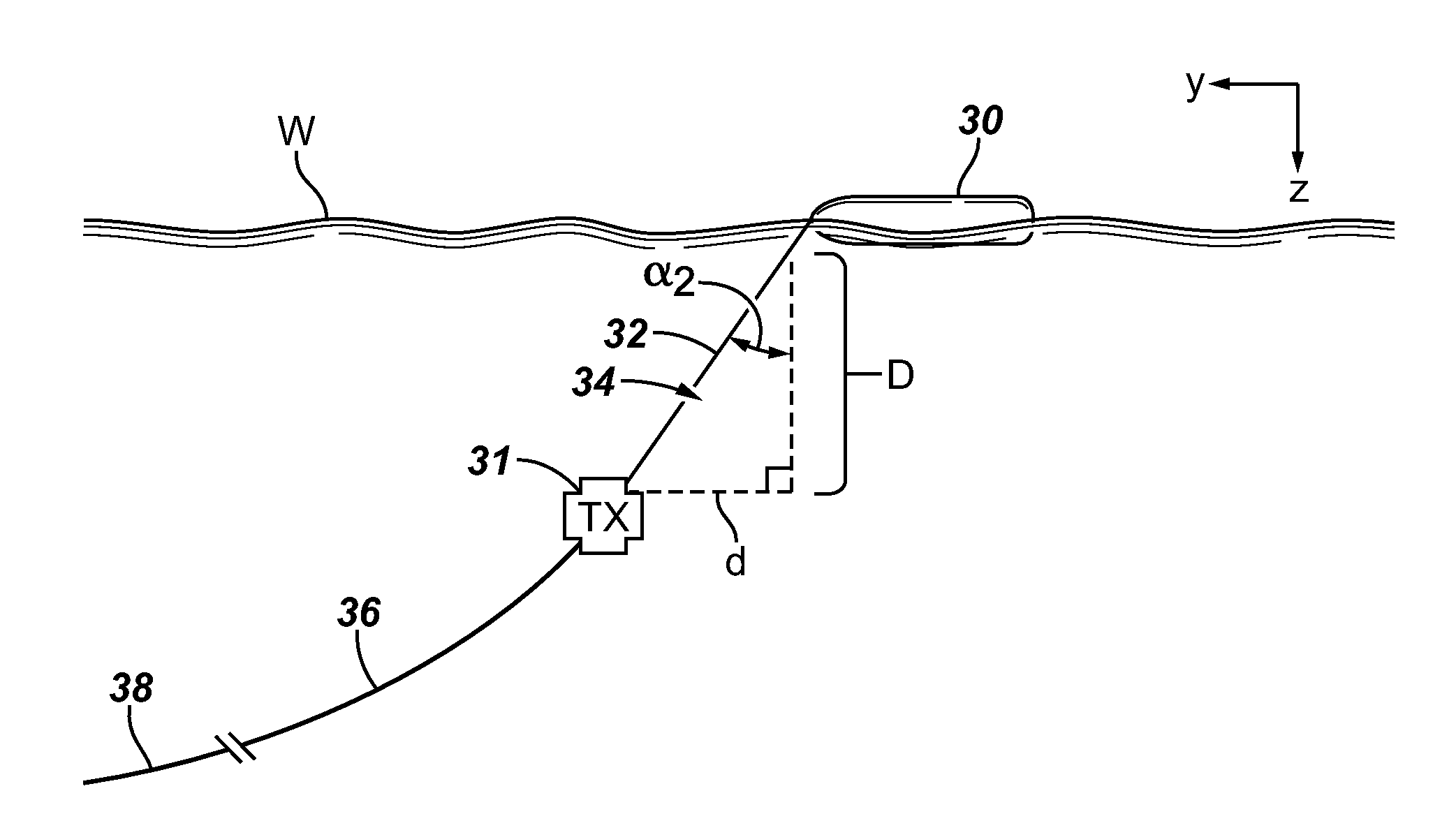
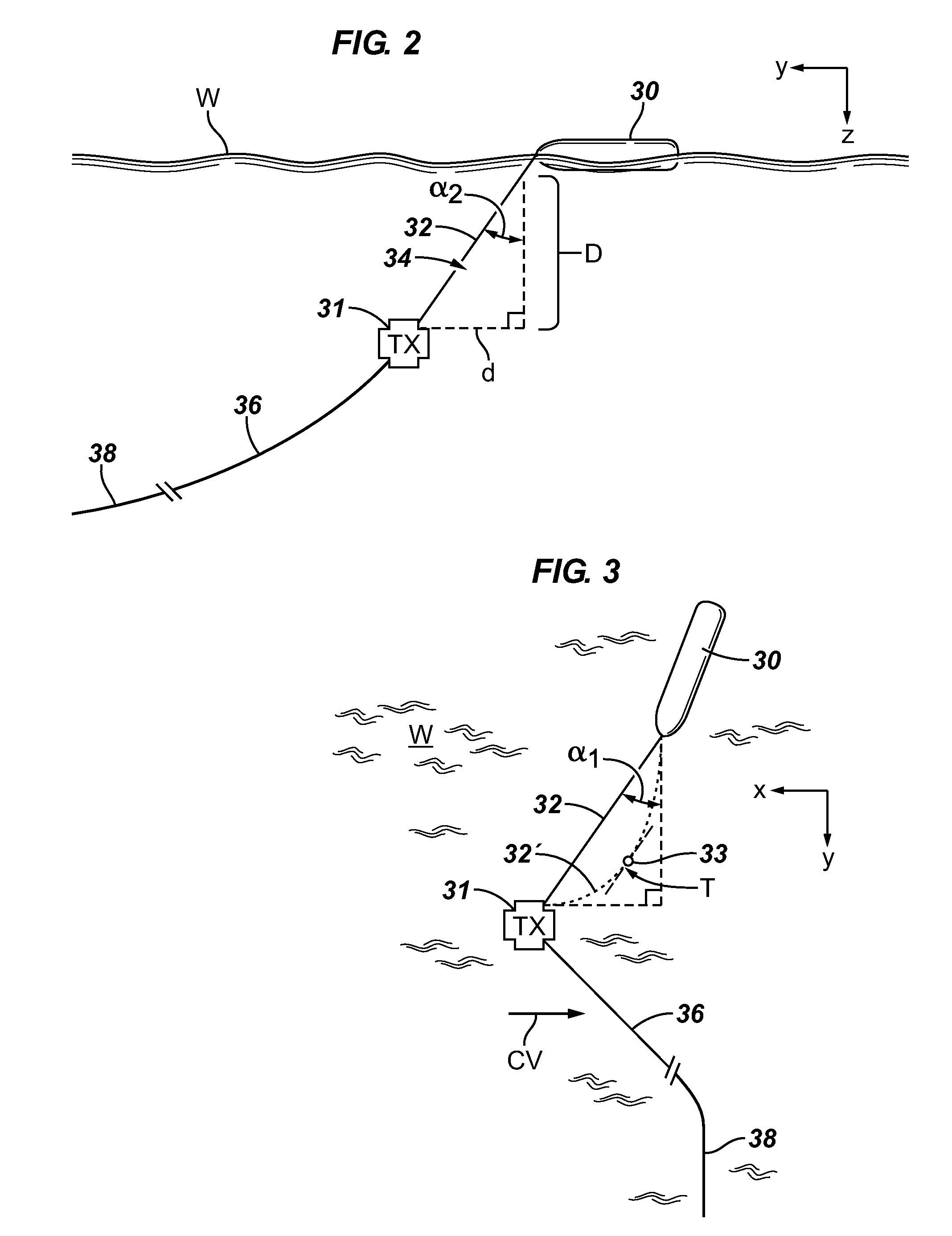
[0036]In certain embodiments, seismic streamers are positioned relative to each other by acoustic ranging. These relative positions are then related to an earth fixed coordinate reference frame, navigation reference frame, body reference frame, or other reference frame typically provided by satellite (for example, GPS, GLONASS, or other satellite positioning system, or combination thereof) control points on towed buoys (tail or streamer front buoys) on the sea surface above the submerged streamers. An acoustic device is employed that determines a distance from the towed buoy to one or more of the submerged components (whose relative positions are kno...


PUM


Abstract

A method comprising determining coordinates of a first point rigidly attached to a rigid body floating on the sea surface in a desired coordinate reference frame; measuring orientation parameters of the rigid floating body to determine 3D offset in the coordinate reference frame of the first point to any point on or rigidly attached to the body; applying a 3D coordinate shift from the first point to a second point rigidly attached to the body, thus determining coordinates of the second point in the desired reference frame; determining a distance from the second point to one or more devices that are components of a seismic acquisition spread, by comparing transmission times of a signal to recording times of transmitted signals and multiplying by a signal propagation rate; and determining relative positions of components of the spread to each other and to devices rigidly attached to the rigid body.

Description

BACKGROUND OF THE INVENTION[0001]Marine seismic exploration investigates and maps the structure and character of subsurface geological formations underlying a body of water. One or more streamer cables containing acoustic and / or electromagnetic (EM) seismic receivers are deployed into the water behind a vessel, and one or more sources may be towed by the same or different vessel. Less than perfect knowledge of the actual positions of the source at the time of firing and receivers at the time of arrival of reflected seismic waves may result in less than acceptable seismic data.[0002]When performing marine seismic imaging of the subsurface strata one needs to establish the position and depth of the seismic source and the receivers (either acoustic or EM). Conventionally they have been referenced to the sea surface, but this has the disadvantage that the actual surface varies up and down with time and it is thus at a different distance from the seabed at the different times of the seis...

Claims


Application Information

Patent Timeline
Patent Type & Authority Applications(United States)
IPC IPC(8): G01V1/38
CPCG01V1/3835
Inventor WELKER, KENNETH E.FRIVIK, SVEIN ARNE
Owner WESTERNGECO LLC
Why Eureka
Try Eureka