Navigational planning and display method for the sailor's dilemma when heading upwind

a navigational planning and display method technology, applied in the direction of position fixation, navigation instruments, electric devices, etc., can solve the problems of little wind power, little if any clues, and the sailboat cannot head straight into the wind, so as to reduce the tacking time to the destination, the optimal sailing direction is quickly determined.

Active Publication Date: 2009-11-19
SUMMERS
View PDF13 Cites 48 Cited by
  • Summary
  • Abstract
  • Description
  • Claims
  • Application Information

AI Technical Summary

Benefits of technology

[0016]The object of the present invention is therefore to provide a convenient method for calculating Tacking Time to Destination and determining the optimal heading for minimizing this time. In accordance with the objectives of the invention, two implementations will be disclosed for determining the optimal route on board: algorithms for calculations on computer or GPS, and a manual device with moving dials to indicate the best heading.
[0017]This invention resolves a long-standing dilemma in seafaring, to quickly determine the optimal sailing heading. A further advantage of this invention is its use with novice sailors. Beginners often have trouble estimating where the wind is coming from, and how to set the sail at one angle to the wind, independent of the boat's heading. It is also not intuitive to some learning sailors that you can sail into the wind, and that a sailboat could in principle go faster than the wind (since modern sails are powered by lift on most points of sail, and are not simply pushed by the wind). For training the beginning sailor before they set off on their own, it would be useful to be able to illustrate the tradeoff between heading upwind to the target and heading off the wind, and to demonstrate the optimal route for minimizing the Tacking Time to Destination.

Problems solved by technology

But even with all of this information, there are few if any clues that make the judgment of the optimal heading intuitive.
However, a sailboat cannot head straight into the wind.
If it went straight along the black line (called the Rhumb Line), it would have little wind power and substantial wind resistance, perhaps reducing the boat speed to 2 knots.

Method used


Image

  • Navigational planning and display method for the sailor's dilemma when heading upwind
  • Navigational planning and display method for the sailor's dilemma when heading upwind
  • Navigational planning and display method for the sailor's dilemma when heading upwind

Examples


Embodiment Construction

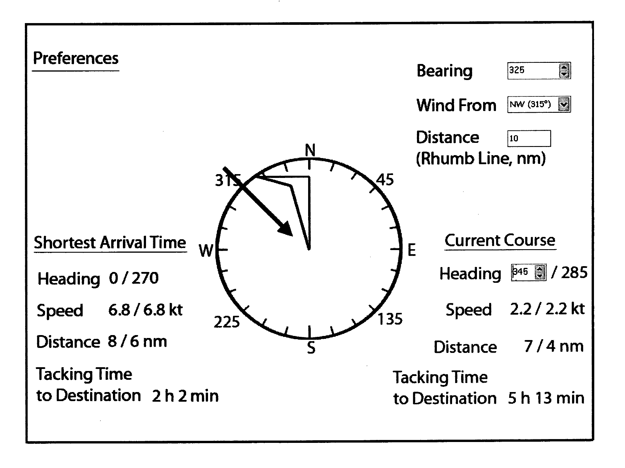
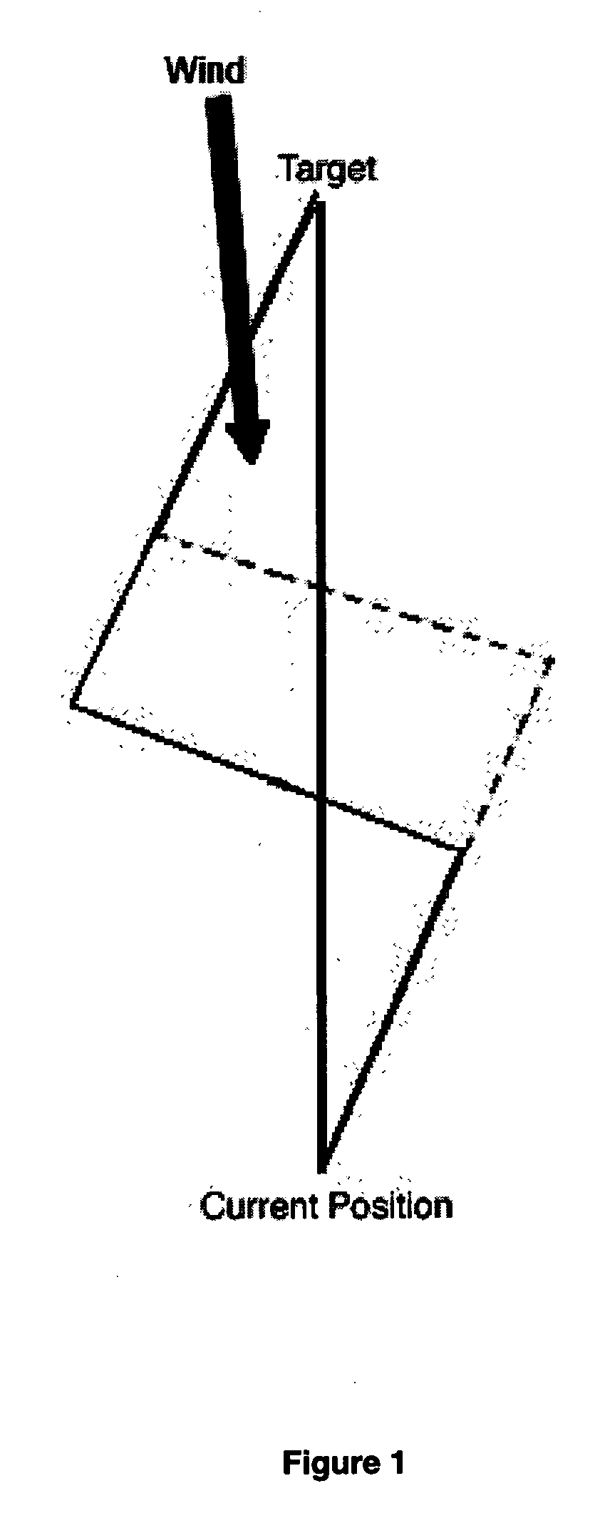
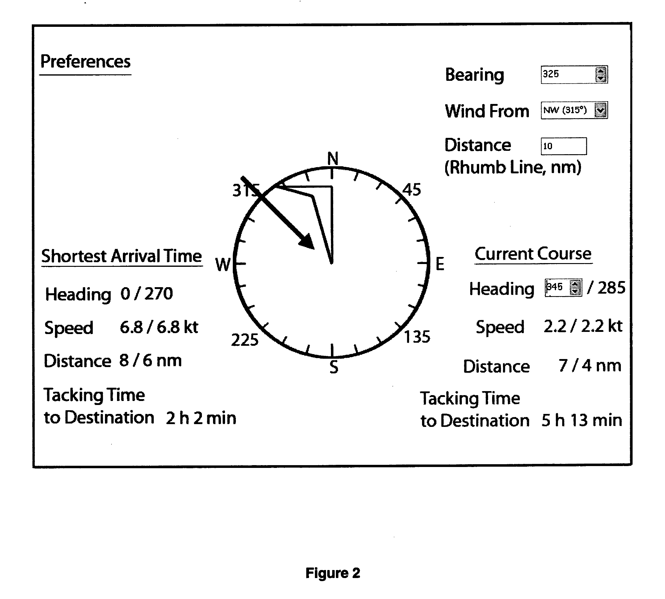
[0024]Placing all of the calculations and comparisons in a software program provides a precise way to determine the optimal heading to minimize Tacking Time to Destination. While this can be strictly numbers and text, the software could also have a graphical user interface such as showing routes on a chart display, on an aerial photo, on a GPS chartplotter or within a navigable 3D scene model—any of which could illustrate the directions, speeds and distances involved. A preferred embodiment is shown in FIG. 2, where the directions are shown on a compass face. In this type of software it is possible to give the user the option of specifying the graphic used in the background such as a compass or a chart, for example. The preferences can be set for North Up or for Heading Up if the routes are displayed. On the compass display, the user's location is assumed to be at the center of the compass. The destination is indicated by a large dot on the edge of the compass. The direction the win...


PUM


Abstract

A method is disclosed that resolves a long-standing seafaring problem of how close to the wind to sail. Sailboats need a convenient way to determine the optimal heading to minimize the Tacking Time to Destination (TTD). Unlike Velocity Made Good (VMG), the method disclosed here allows route planning before the trip, predicts travel time on different points of sail, allows comparison of the optimal tacking routes, and also plots the different routes so that it is inherently obvious that a particular tacking angle is longer and more off-course but will arrive sooner because of the speed on that heading. These principles can be implemented with manual dials that define the distance and speed, to calculate the relative or actual travel time on a leg without using electronics. Software is also described that visually illustrates the current and optimal headings by calculating Tacking Time to Destination before departure.

Description

FIELD OF INVENTION[0001]This invention provides a method to solve the long-standing sailor's dilemma of defining a navigational route with the best tradeoff between speed and distance when sailing upwind, in order to obtain the shortest Tacking Time to Destination (TTD). Unlike assessments of Velocity Made Good (VMG), the methods disclosed here predict travel time, allow the current and optimal routes to be plotted and understood visually, and can be conveniently calculated without boat movement and trial and error route testing. The methods disclosed make the current generation of GPS chartplotters more useful for sailors, and can also be implemented in a manual device with moving dials to determine headings.BACKGROUND OF INVENTION[0002]In sailing, whether for long passages, short day-sails or for racing, it is important to be able to determine the best heading upwind. There do not appear to be any electronic devices, mechanical mapping tools or even standardized calculations avail...

Claims


Application Information

Patent Timeline
Patent Type & Authority Applications(United States)
IPC IPC(8): G01C21/22
CPCB63B49/00B63J2099/008Y02T70/747G06G1/0052G01C21/203B63B2035/009Y02T70/00B63B79/40
Inventor SUMMERS, CRAIG
Owner SUMMERS
Why Eureka
Try Eureka