Universal GPS Traffic Monitoring System

a traffic monitoring and universal technology, applied in direction finders using radio waves, instruments, analogue processes for specific applications, etc., can solve the problems of inability to accurately predict traffic conditions, etc., to achieve the effect of reducing computation load and power consumption of mobile devices

Inactive Publication Date: 2010-04-22
KIM JIN HONG
View PDF3 Cites 88 Cited by
  • Summary
  • Abstract
  • Description
  • Claims
  • Application Information

AI Technical Summary

Benefits of technology

[0017]A traffic data collection process and monitoring system that uses a plurality of GPS enabled mobile devices to intermittently or continuously transmit near at real-time traffic speed, direction and location information to a server. The sever processes and transforms the information from a plurality of mobile devices and the saves it in a database containing a plurality of pre-designated traffic monitoring points in the region. The speeds from a plurality of mobile devices for a particular traffic monitoring point (called TMPs) are transformed and averaged. Because the processing is done on the server, the computational load and power consumption of the mobile devices is reduced.

Problems solved by technology

In some cases, such shortcomings may arise at least in part because there may not be a single source of reliable live traffic information.
However, each of these sources of traffic information may have inherent limitations.
For example, construction alerts are often out of date, and incident reports are often delayed.
Moreover, data from loop sensors may take time to calculate, and more sophisticated sensors cover only a fraction of the nation's roads.
However, DOT-provided traffic data is often delayed by up to thirty or more minutes.
Accordingly, DOT-provided data often does not provide up-to-the-second, truly local traffic information.
Traffic data from sources such as those described above may not provide accurate and detailed information about traffic from mile to mile.
For example, many traffic monitoring systems may only provide a gross level of detail.
In many cases, current traffic monitoring systems may not provide enough detail to allow drivers to accurately determine alternative routes around a traffic obstruction.
However, current systems may require mobile devices to download “virtual trip line” data.
This calculation generally imposes significant computational overhead and may decrease battery life, often significantly.
In addition, virtual trip line systems by their very nature may have difficulty providing detailed traffic information about relatively short road segments (as they only collect data when a mobile device passes a virtual trip line).

Method used


Image

  • Universal GPS Traffic Monitoring System
  • Universal GPS Traffic Monitoring System
  • Universal GPS Traffic Monitoring System

Examples


Embodiment Construction

)

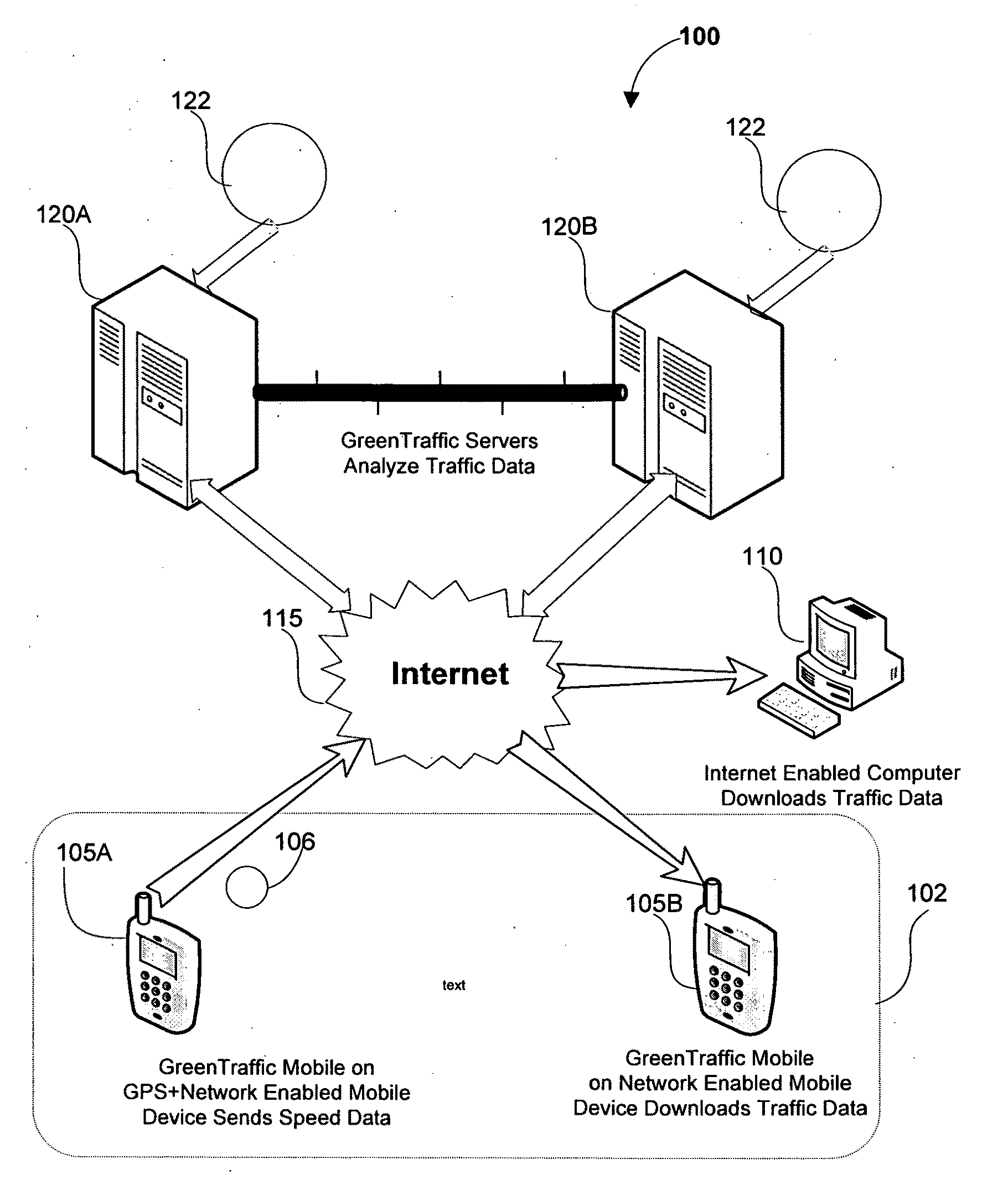
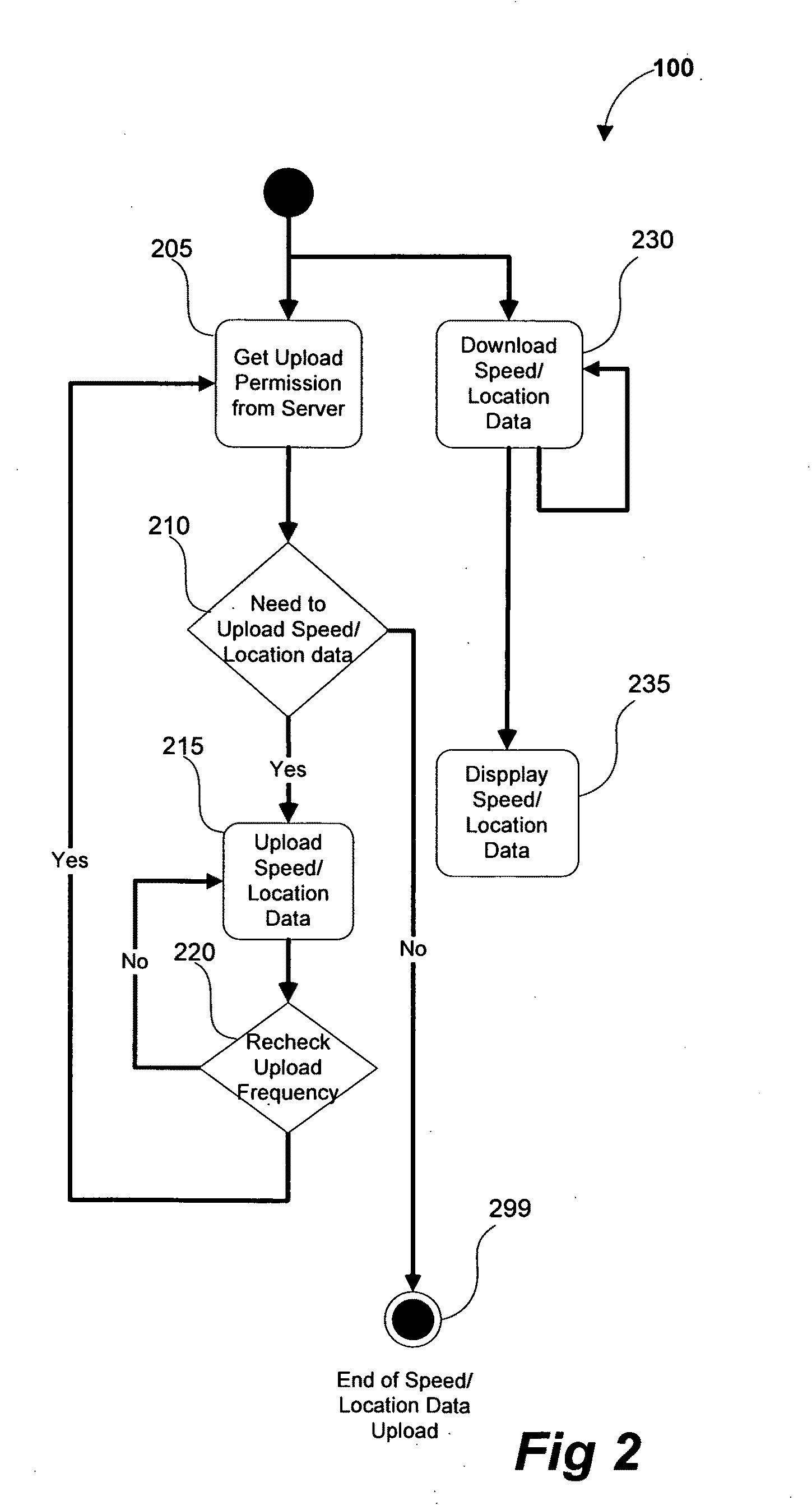
[0031]The detailed description that follows is represented largely in terms of processes and symbolic representations of operations by conventional computer components, including a processor, memory storage devices for the processor, connected display devices and input devices. Furthermore, these processes and operations may utilize conventional computer components in a heterogeneous distributed computing environment, including remote file Servers, computer Servers and memory storage devices. Each of these conventional distributed computing components is accessible by the processor via a communication network.

[0032]Reference is now made in detail to the description of the embodiments as illustrated in the Figs. While embodiments are described in connection with the Figs. and related descriptions, there is no intent to limit the scope to the embodiments disclosed herein. On the contrary, the intent is to cover all alternatives, modifications and equivalents. In alternate embodiments...


PUM


Abstract

A traffic data collection process and monitoring system that uses a plurality of GPS enabled mobile devices to transmit near at real-time traffic direction and speed information to a server and or/at real-time (sub 10 second latency). The sever processes the information thereby reducing the computational load and power consumption of the mobile devices. The system uses a Traffic Pattern Recognition software program that accurately recognizes only valid traffic data while filtering out unwanted traffic data. The system creates a Distributed Traffic Data Store database containing the average speeds for designated traffic monitoring points created for the region. During use, a request for traffic data containing the boundary data and the zoom level is sent from the mobile device to the server. The server then reviews the requests and determines with specific Distributed Traffic Data Store database contains the information. The server then creates a compressed file containing the traffic information relevant to the TMPs in the request and sends it to the mobile device.

Description

[0001]This utility patent is based on can claims the filing date of U.S. Provisional Patent Application, filed on Oct. 10, 2008, (Ser. No. 61 / 104,694) and U.S. Provisional Patent Application filed on Apr. 4, 2009 (Ser. No. 61 / 166,716).BACKGROUND OF THE INVENTION[0002]1. Field of the Invention[0003]The present disclosure relates to monitoring traffic data, and more particularly to aggregating traffic data from Global Positioning System (“GPS”) enabled mobile devices.[0004]2. Description of the Related Art[0005]Currently, traffic-monitoring systems act more as blunt instruments, than as precision tools. For example, what appears to be gridlock on a traffic monitoring system may have completely vanished by the time a driver arrives; other times, a driver may head straight into a traffic jam without receiving any alert.[0006]In some cases, such shortcomings may arise at least in part because there may not be a single source of reliable live traffic information. Therefore, current traffi...

Claims


Application Information

Patent Timeline
Patent Type & Authority Applications(United States)
IPC IPC(8): G08G1/00G01S19/24
CPCG01S5/0027G08G1/01G01S19/14
Inventor KIM, JIN HONG
Owner KIM JIN HONG
Why Eureka
Try Eureka