System and method for detecting, locating and identifying objects located above the ground and below the ground in a pre-referenced area of interest

a technology applied in the field of system and method for locating and identifying objects located above the ground and below the ground in a pre-referenced area of interest, can solve the problems of large amount of false alarms, very dangerous and expensive detection, and slowness, and achieves the effect of reducing the number of false alarms

Inactive Publication Date: 2011-02-17
PONTIFISIA UNIVERSIDAD KATOLIKA DE CHILE
View PDF12 Cites 33 Cited by
  • Summary
  • Abstract
  • Description
  • Claims
  • Application Information

AI Technical Summary

Benefits of technology

[0021]The system for detecting, locating and identifying antipersonnel and antitank mines for application in humanitarian demining considers the integration of a mathematical modeling and computer simulation subsystem, considering the calculation of natural frequencies and resonance of antipersonnel mines on unbounded, inhomogeneous environment, in order to determine the optimal frequencies at which a synthetic aperture radar (SAR) is to be operated for mine detection; a radar design and building subsystem, considering design, integration, installation and operation of a synthetic aperture radar based on selected frequencies in modeling and simulation subsystem, implemented in an air platform of the helicopter type and adjustment for use on the ground; an image re-building and processing subsystem, which considers identification and classification of signals delivered by the radar and their conversion to output data through the implementation of efficient built-in algorithms and software allowing subsequent mine georeferencing; and a georeferencing and risk map subsystem considering the orientation of the data submitted by the image re-building and processing subsystem and general and specific location of each mine placed on the ground, through the use of differential geographic position system (DGPS) technology and adjustment and display dedicated software.

Problems solved by technology

High false alarm rate leads to slow, very dangerous and expensive detection.
In the national and international scope, the situation is critical since there are no modern techniques, no reliable data to allow for carrying out good decision making with respect to demining process.
It is thus apparent that in the absence of these advances, uncertain investments will still be made which will not generate knowledge, which will not involve country stakeholders that must and can generate value in this scope and do not consider fundamental variables which unnecessarily involves and increases risk.
The main disadvantages however are: non-homogeneous subsoil which may result in a large amount of false alarms in addition to very sensitive performance to complex interactions such as metal content, radar frequency, soil mixtures and surface soil smoothness (humidity, etc.).
However, mine detection using GPR is complex mainly due to the material present in the site, such as rocks, stones, metals, waste, etc., dominating the obtained data and hiding mine information.
The main disadvantage however, is that sensors should be in contact with the surface, which may cause the mine to be detonated.
A further disadvantage is that it does not work properly in very dry areas such as deserts or rocky surfaces since conductivity is very weak.
In addition, it only serves for detecting objects that are very close to the surface.
Since photons penetrating the ground are impossible to be captured, as it is unfeasible to place an X-ray detector under the mines, X-Ray Compton scattering principle is used by these systems, i.e. photons irradiated by the object when receiving X-rays are captured.
However, due to the low range of energy needed by the sensor, the use of this technology is limited to surface mine detection (less than 10 cm from the surface), since an appropriate signal to noise will not be obtained by mines placed deeper.
The main disadvantage however is that performance is highly variable and it greatly depends on environment characteristics.
They have a low false alarm rate, however the detector may be misled by bottles or cans.
The main disadvantage is that they are able to detect deeply buried mines.
In addition, sampling speed is too slow: 2-15 min / m2.
However, relative numbers of specific atoms can at best be measured through these methods, but the present molecular structure can not be determined through them.
This for example causes water to produce such a large number of false alarms, due to its high hydrogen content.
However, none of these documents uses ground marking based methodology for georeferencing, which provides better accuracy and safety in determining the coordinates of the detected objects in the image, resulting in a final risk map whether it is paper or digital.

Method used


Image

  • System and method for detecting, locating and identifying objects located above the ground and below the ground in a pre-referenced area of interest
  • System and method for detecting, locating and identifying objects located above the ground and below the ground in a pre-referenced area of interest
  • System and method for detecting, locating and identifying objects located above the ground and below the ground in a pre-referenced area of interest

Examples


Embodiment Construction

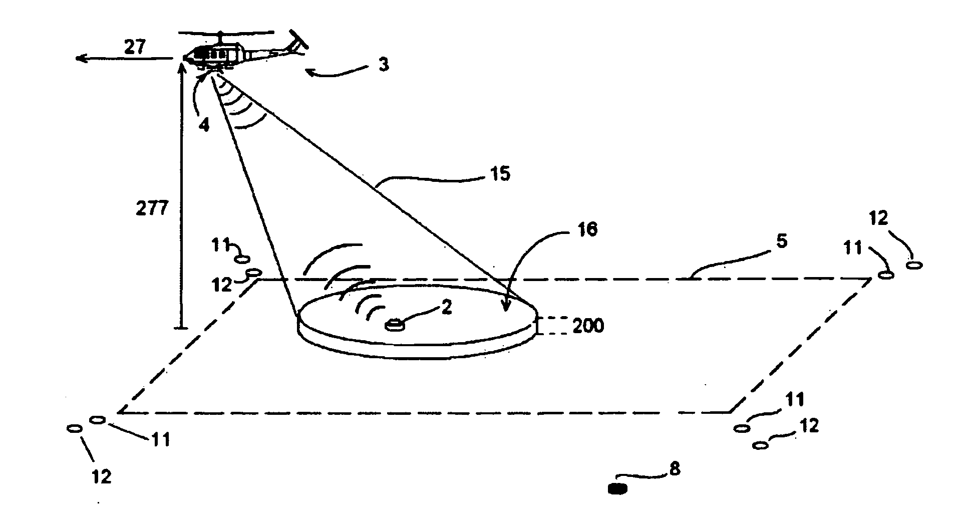
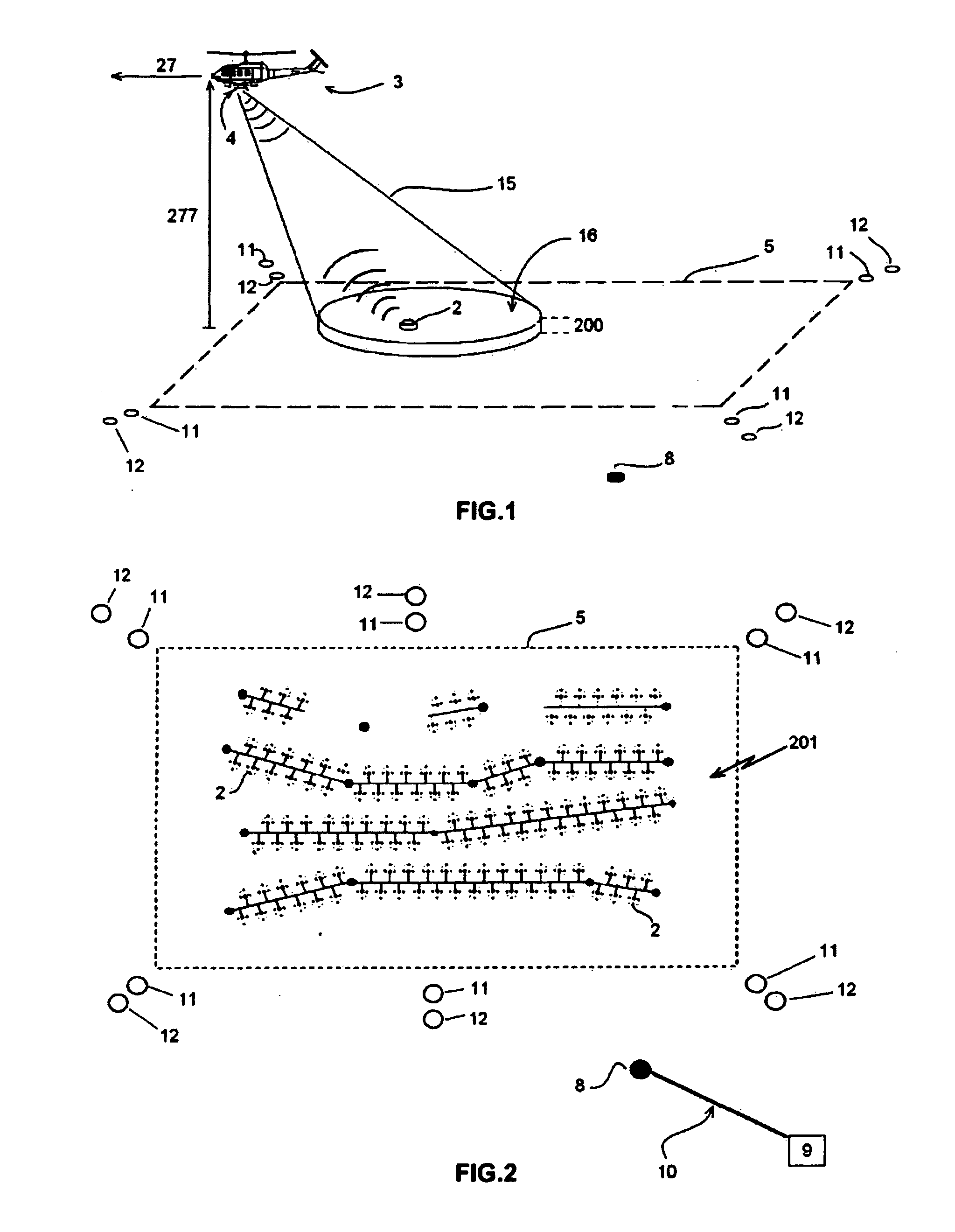
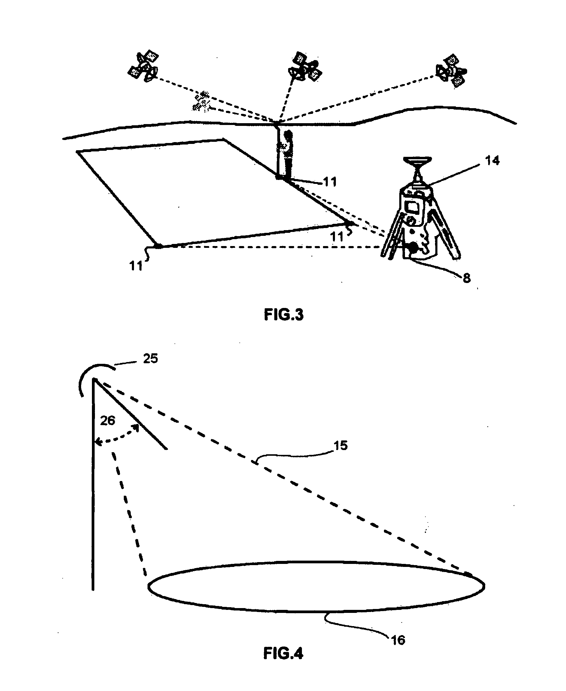
[0049]The system (1) for detecting, locating and identifying of antipersonnel and antitank mines (2) in its application to humanitarian demining, mainly comprises an airborne vehicle (3), preferably of the helicopter type, which incorporates a radar (4), preferably a stepped frequency radar with the respective antenna and graphical interface. In this type of radar, frequency scanned is not continuous but stepped, synthesizing a high-bandwidth pulse compression technique through the use of sequential transmissions of discrete frequencies on an established band. Its advantages are allowing high resolution as well as continuous wave transmission, both features being highly significant in short-range and high-precision applications, in addition since its architecture is of the heterodyne type, it is possible to set very narrow bandwidths as well as frequency generation is easily achieved through the use of frequency synthesizers, which ensure the required frequency step accuracy. Finall...


PUM


Abstract

The invention relates to a system and method for detecting, locating and identifying objects located above ground or below ground in an area of interest, comprising an airborne vehicle which circumscribes the area of interest and which includes a built-in radar having an antenna with a respective transmitter and receiver, signal-processing means, data-storage means and graphical interface means. According to the invention, the area of interest has been pre-referenced and the radar is a heterodyne ground penetration radar (GPR). The signal transmitted by the antenna generates a beam that illuminates a strip of earth, consisting of a sinusoidal electromagnetic signal having a frequency that is varied in precise pre-determined progressive steps. This signal is mixed with the received (reflected) signal, thereby producing two sets of values corresponding to the phases of each frequency step or stage Said sets of values, which are obtained throughout successive sweeps (as the antenna moves), are stored in the storage means and subsequently processed in the processing means in order to obtain a final map or image of the location of the objects above ground or below ground.

Description

FIELD OF THE INVENTION[0001]The invention object of the present patent application relates to an integrated system for detecting, locating and identifying antipersonnel and antitank mines for application in humanitarian demining through a GPR based non-invasive electromagnetic geophysical technique.DESCRIPTION OF PRIOR ART[0002]Conventional antipersonnel mine detection has been carried out mainly through methods that are not different from those used during Second World War, that is, a human operator uses a metal detector and performs a thorough and slow scanning on the affected area. High false alarm rate leads to slow, very dangerous and expensive detection. Adjusting the detectors to decrease false alarm rate involves that some mines are not detected.[0003]In the national and international scope, the situation is critical since there are no modern techniques, no reliable data to allow for carrying out good decision making with respect to demining process. It is thus apparent that...

Claims


Application Information

Patent Timeline
Patent Type & Authority Applications(United States)
IPC IPC(8): G01S13/88
CPCG01S13/885G01V3/17G01S19/43G01S13/89G01C15/00
Inventor DURAN TORO, MARIO MANUELGUARINI HERRMANN, MARCELO WALTER
Owner PONTIFISIA UNIVERSIDAD KATOLIKA DE CHILE
Why Eureka
Try Eureka