
Method and system for estimation of mobile station velocity in a cellular system based on geographical data

a technology of cellular system and geographic data, applied in the field of environmental modeling, can solve the problems of inability to accurately locate mobile terminals, mobile telephones, in a wireless system, for example, a cellular telephone communication system, and difficulty in predicting the strength of received signals of mobile terminals operating in actual environments, and lack of available information about propagation environments

Active Publication Date: 2011-11-24
CYBERBIT
View PDF1 Cites 177 Cited by
  • Summary
  • Abstract
  • Description
  • Claims
  • Application Information

AI Technical Summary

Problems solved by technology

Accurate location of mobile terminals, e.g. mobile telephones, in a wireless system, for example, a cellular telephone communication system, has been a difficult challenge.
Prediction of received signal strength of signals from mobile terminals that may be operating in actual environments may be a difficult task.
A source of difficulty may be a lack of available information about a propagation environment, at least in a precision that may be required for an accurate application of a theory of wave propagation, e.g. electromagnetic wave theories presented by James Clerk Maxwell.
This lack of information may be inherent in a modeling problem as a propagation environment may be changing dynamically, and also may be random in nature.

Method used


Image

  • Method and system for estimation of mobile station velocity in a cellular system based on geographical data
  • Method and system for estimation of mobile station velocity in a cellular system based on geographical data
  • Method and system for estimation of mobile station velocity in a cellular system based on geographical data

Examples


Embodiment Construction

In the following detailed description, numerous specific details are set forth in order to provide a thorough understanding of the invention. However, it will be understood by those skilled in the art that the present invention may be practiced without these specific details. In other instances, well-known methods, procedures, and components have not been described in detail so as not to obscure the present invention.

Embodiments of the invention may be used in a variety of applications. Some embodiments of the invention may be used in conjunction with various devices and systems, for example, a transmitter, a receiver, a transceiver, a transmitter-receiver, a wireless communication station, a wireless communication device, a wireless Access Point (AP), a base station, a modem, a wireless modem, a Personal Computer (PC), a desktop computer, a mobile computer, a laptop computer, a notebook computer, a tablet computer, a netbook computer, a server computer, a handheld computer, a handh...


PUM


Abstract

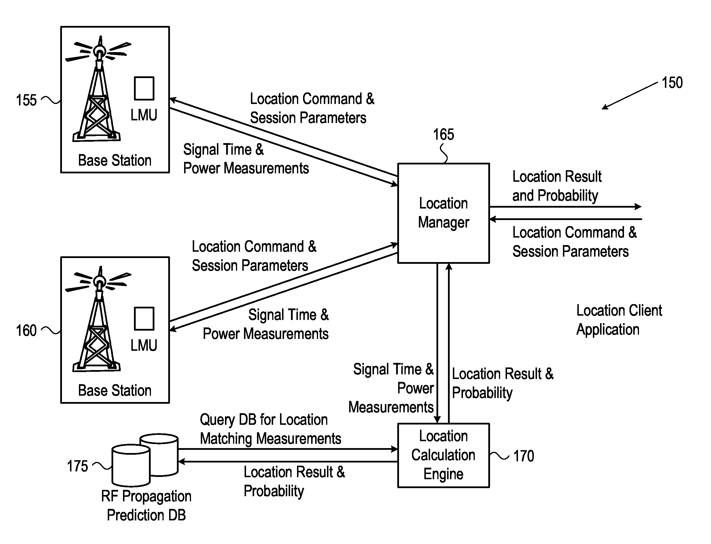
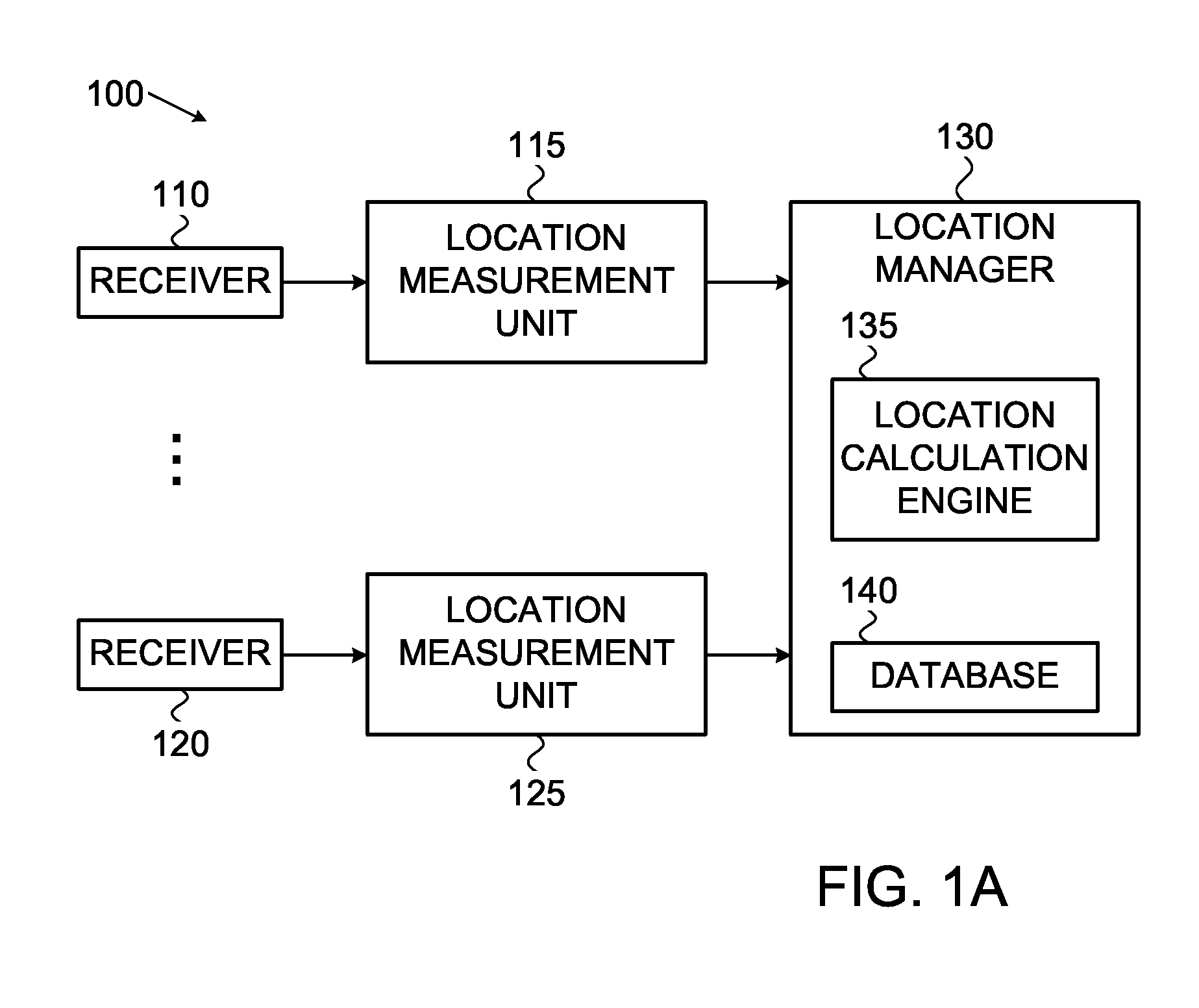
A system and method for estimating velocity of a mobile station in a wireless communication system using time-frequency signal processing and a geographical database. The geographical database is used for prediction of ray trajectory and ray power to provide an estimate of propagation delay associated with database points.

Description

FIELD OF THE INVENTIONThe present invention relates generally to environmental modeling, and in particular to calibration of an environmental model using wireless signals.BACKGROUND OF THE INVENTIONAccurate location of mobile terminals, e.g. mobile telephones, in a wireless system, for example, a cellular telephone communication system, has been a difficult challenge. Several techniques have been proposed and partially developed to address this problem, but there remains a need for a technique with greater precision of location. It is generally desirable that such a location system be relatively low cost, require little or no modification to existing user hardware and software, and not disrupt operation of the communication system.Prediction of received signal strength of signals from mobile terminals that may be operating in actual environments may be a difficult task. A source of difficulty may be a lack of available information about a propagation environment, at least in a preci...

Claims


Application Information

Patent Timeline
Patent Type & Authority Applications(United States)
IPC IPC(8): H04W24/00G01S3/02H04W4/029
CPCG01S5/0252G01S5/0294H04W4/028H04W28/04H04W64/006G01S11/026H04W4/029
Inventor LEVIN, MOSHEFREEDMAN, AVRAHAM
Owner CYBERBIT
Learn More