
Wireless localization method based on an efficient multilateration algorithm over a wireless sensor network and a recording medium in which a program for the method is recorded

a wireless sensor network and multilateration algorithm technology, applied in direction finders using radio waves, instruments, special services for subscribers, etc., can solve the problems of high cost, inconvenient indoor channel environment of gps, inability to achieve precise localization, etc., to reduce the error in estimated distance, improve the accuracy of estimated location of blind nodes, and the effect of reducing the error

Active Publication Date: 2013-02-21
SEOUL NAT UNIV R&DB FOUND
View PDF0 Cites 83 Cited by
  • Summary
  • Abstract
  • Description
  • Claims
  • Application Information

AI Technical Summary

Benefits of technology

The present invention is a wireless localization method that improves the accuracy of estimating the location of blind nodes by finding and reducing errors in estimated distance. This algorithm is simple but powerful, making it easy to implement and efficiently perform location estimation in real-time. Additionally, the method improves accuracy even with a small number of nodes, especially when using only a few nodes.

Problems solved by technology

However, the GPS provides a high performance in an outdoor environment, but since the location information is obtained using satellites there is a limit in that it is hard to achieve a precise localization indoors.
Therefore, the GPS is not suitable for a localization system in indoor channel environments or with low-cost devices.
A method for estimating a location without information on the distance between transmitter side and receiver side in estimating the location of a user is the range free approach, but since the method requires a high cost and has to store enormous amount of information, its real feasibility is low.
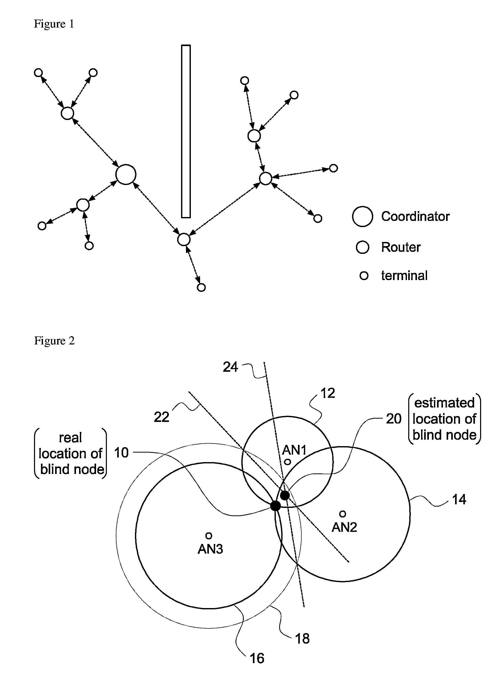
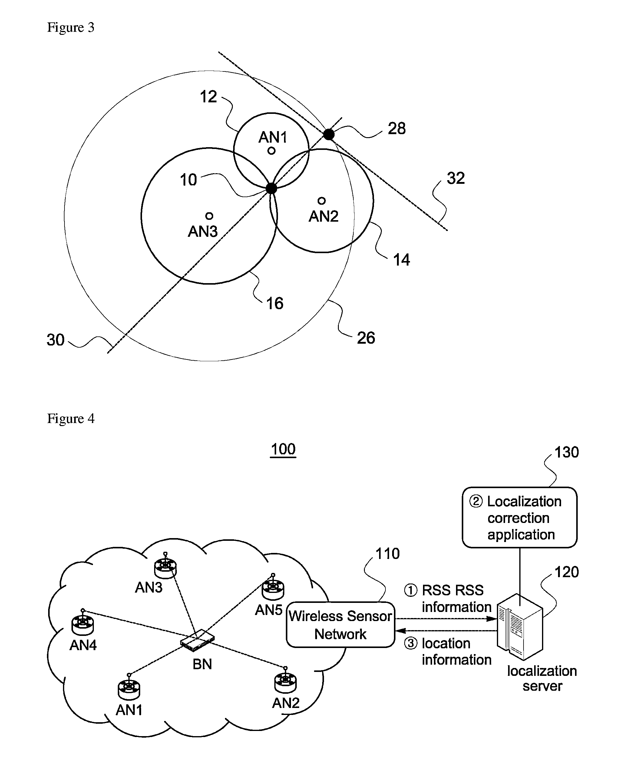
However, if there is a large error in estimating the distance between transmitter side and receiver side, the distance is estimated too large or too small, such that one circle may be separated from the other circle(s) or one circle may include the other circle(s) completely, that is, an occasion that the three circles are not able to form cross lines (see FIG. 3) may occur in real situation.
However, since such conventional wireless localization method based on error-correction of estimated distance has an algorithm of complicated and recursive calculations and the amount of calculations increases further to increase accuracy of localization, it is not suitable to the real-time wireless localization service.
For it is very hard to know precisely two channel factors.
Therefore, it does not become a practical method.

Method used


Image

  • Wireless localization method based on an efficient multilateration algorithm over a wireless sensor network and a recording medium in which a program for the method is recorded
  • Wireless localization method based on an efficient multilateration algorithm over a wireless sensor network and a recording medium in which a program for the method is recorded
  • Wireless localization method based on an efficient multilateration algorithm over a wireless sensor network and a recording medium in which a program for the method is recorded

Examples


Embodiment Construction

[0034]Referring to the figures, embodiments of the present invention are described in detail below.

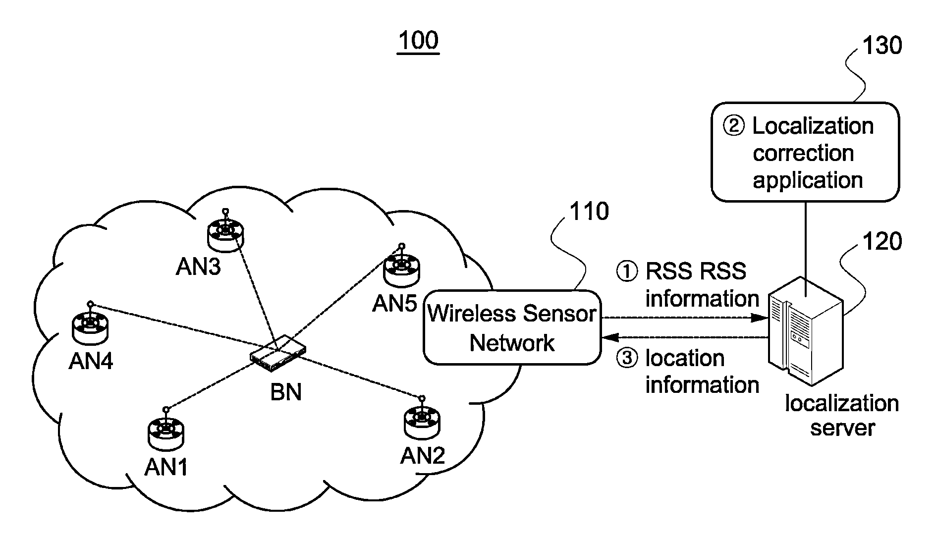
[0035]The wireless localization method according to the present invention measures distances from blind node to each reference node using RSS, and estimates the location of the blind node through trilateration using the estimated distance values.

[0036](1) Indoor Path-Loss Model

[0037]RSS can be measured with respect to each of packets which the reference nodes received from the blind node. It is well known that the strength of the transmitted signal decreases proportional to the distance between the transmitting side and the receiving side. Due to the random property of shadowing, it has a specific average value and follows a Gaussian distribution with the average value as a center (when the distance between the transmitting side and the receiving side is constant). When using Gaussian model, the strength Pij (average value of RSS ensemble) of signal which the i-th reference node (recei...


PUM


Abstract

A wireless localization technology using efficient multilateration in a wireless sensor network is disclosed. After calculating estimated distances from each of at least three reference nodes to a blind node using received signal strength of wireless signals that the at least three reference nodes received from the blind node, the estimated location of the blind node is obtained through multilateration using the calculated estimated distances. To correct error in the estimated location, the estimated distances are used, and the error correction direction and error correction distance for the estimated location are calculated by applying a largest weight to the reference node closest to the estimated location. The error of the estimated location is corrected by move the estimated location of the blind node by the calculated error correction direction and error correction distance. Calculation for the error correction is very simple and fast.

Description

BACKGROUND OF THE INVENTION[0001]1. Field of the Invention[0002]The present invention relates to a wireless localization method based on a wireless sensor network, more specifically to a wireless localization method, which is able to correct localization error precisely in real time in a wireless localization through multilateration algorithm using received signal strength indicator (RSSI). Here, the term ‘multilateration’ is a concept including trilateralism and indicates a method for estimating an estimated location of a blind node using more than three reference nodes.[0003]2. Background Art[0004]As the interest on smart phones increases explosively, a location based service (LBS) receives spotlight, and for example, location-recognizing applications such as augmented reality, medical care, home network, monitoring applications, etc. are popular. For such a LBS, a localization on location of user requesting the service must be achieved precisely.[0005]A well-known localization sy...

Claims


Application Information

Patent Timeline
Patent Type & Authority Applications(United States)
IPC IPC(8): H04W64/00
CPCG01S5/0289G01S11/06G01S5/14H04W64/00
Inventor KIM, SEONG CHEOLLEE, JUNG KYU
Owner SEOUL NAT UNIV R&DB FOUND
Learn More