Method and System for Geophysical Modeling of Subsurface Volumes Based on Label Propagation

a geophysical modeling and label propagation technology, applied in the field of prospecting, can solve the problems of large data amount, computational cost, and inability to adjust local dips,

Active Publication Date: 2015-10-29
EXXONMOBIL UPSTREAM RES CO
View PDF6 Cites 16 Cited by
  • Summary
  • Abstract
  • Description
  • Claims
  • Application Information

AI Technical Summary

Problems solved by technology

However, the method is computationally expensive, which is further compounded by larger data sets.
As a result, the method involves large data amounts and is computationally expensive.
This method uses plane-wave destruction to compute a prediction operator Pij that predicts the seismic character (i.e. amplitudes) of trace j given a character at trace i. This computation is a global optimization problem whereby it seeks to minimize the prediction error for all pairs of nearby traces.
However, a trace is predicted by only one trace preceding it and the local dip cannot be adjusted because the method relies upon the plane-wave destruction computation.
As such, this method may tend to have poor behavior in noisy areas.
Further, similar to the other methods, the optimization problem may be computationally expensive for large number of traces (e.g. 3-D volumes).
However, this approach provides surfaces that are not dense and have gaps that are user-controlled, and the surfaces may be difficult to adjust.
This method may be slow because it needs to perform multiple iterations to solve the partial differential equation that describes harmonic or biarmonic interpolation (e.g., iterations are proportional to one dimension of the data).
Accordingly, this method is inefficient and the multiple iterations further complicate the inefficiencies.

Method used


Image

  • Method and System for Geophysical Modeling of Subsurface Volumes Based on Label Propagation
  • Method and System for Geophysical Modeling of Subsurface Volumes Based on Label Propagation
  • Method and System for Geophysical Modeling of Subsurface Volumes Based on Label Propagation

Examples


first embodiment

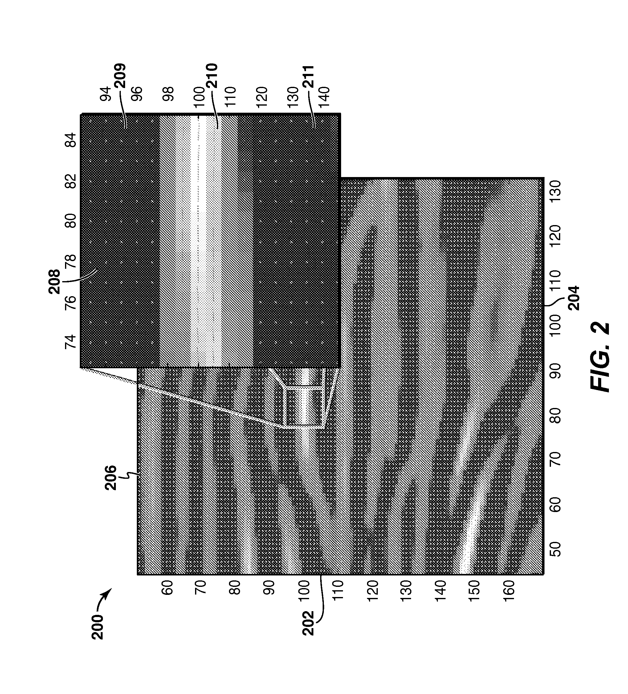
[0041]As a first embodiment, a method of computing a tangent to the closest ridge curve within a fixed neighborhood around each spatial location P is provided for two dimensions (2-D). Given a spatial location P, which is represented as (Px, Pr), the method involves extracting a neighborhood (denoted N) around it by equation (e1) and recording the amplitude (or attribute) values there denoted by W(Q).

[0042]The neighborhood N may be calculated by equation (e1):

N={(Q:|Qx−Px|y−Py|  (e1),

where subscripts x and y refer to the spatial location along the x-axis and y-axis respectively, and the neighboring location or point Q has spatial coordinates Qx and Qy. , and n is the radius of the neighborhood N. The neighborhood may include a neighborhood size and shape.

[0043]In this calculation, the data values, which may be as many as (2n+1)2, may be expressed as weights to approximate the y-values, which represent time or depth in a seismic line (e.g., composed of one or more seismic traces), as...

second embodiment

[0047]Alternatively, in a second embodiment, a method may involve using the iso-curves and iso-surfaces in an iso-surface method. In this method, local measurements are obtained in a tensor field that includes iso-surface tensor Tp at each location P in the data volume set. Each iso-surface tensor Tp is computed in a similar process. First, a similarity vector is computed using equation (e7):

v→PQ=σ(P,Q)(Q-P)Q-P;(e7)

where the similarity vector is {right arrow over (ν)}pQ. The similarity vector {right arrow over (ν)}pQ may be computed for each of its neighbor points Q in a predefined neighborhood (e.g., the neighbor point Q within a fixed distance of spatial location P). The magnitude of the vector is the similarity σ(P, Q) of the data values at the spatial location P and at neighbor point Q, which may be expressed in equation (e8):

σ(P,Q)=exp(−(data(P)−data(Q)))  (e8)

and the direction is the unit vector that joins spatial location P to point Q (here data(P) and data(Q) are the data va...


PUM


Abstract

Method and system are described for generating a stratigraphic model of a subsurface volume. Measured geophysical data are converted into a vector volume (106) by assigning to each sample in each trace in the data volume a vector representing dip, azimuth or confidence. Then a labeled volume is generated from the vector volume by assigning a label to each sample in an initial trace (1006), then selecting a propagation pattern (1008) and propagating the labels to other traces (1010). Horizons can be extracted (110) from the labeled volume, and utilized to enhance the process of producing hydrocarbons (114).

Description

CROSS-REFERENCE TO RELATED APPLICATION[0001]This application claims the benefit of U.S. Provisional Patent Application 61 / 740,358, filed Dec. 20, 2012, entitled METHOD AND SYSTEM FOR GEOPHYSICAL MODELING OF SUBSURFACE VOLUMES BASED ON LABEL PROPAGATION, the entirety of which is incorporated by reference herein.FIELD OF THE INVENTION[0002]This invention relates generally to the field of prospecting and more particularly to data processing. Specifically, the invention is a method for modeling subsurface volumes for one or more geophysical properties based on label propagation techniques.BACKGROUND OF THE INVENTION[0003]In the oil and gas industry, modeling of the subsurface is typically utilized for visualization and to assist with analyzing the subsurface volume for potential locations for hydrocarbon resources. Accordingly, various methods exist for estimating the geophysical properties of the subsurface volume (e.g., information in the model domain) by analyzing the recorded measur...

Claims


Application Information

Patent Timeline
Patent Type & Authority Applications(United States)
IPC IPC(8): G01V1/34
CPCG01V1/345G01V1/301
Inventor DIMITROV, PAVELIMHOF, MATTHIAS
Owner EXXONMOBIL UPSTREAM RES CO
Why Eureka
Try Eureka