Innovative Orbit Design For Earth Observation Space Missions

a technology for space missions and orbits, applied in the field of innovative orbit design, can solve the problems of high cost of satellite remote sensing systems, and high cost of design, and achieve excellent interferometric capabilities, reduce design cost, and good time performance

Active Publication Date: 2015-12-03
THALES ALENIA SPACE ITAL SPA
View PDF5 Cites 21 Cited by
  • Summary
  • Abstract
  • Description
  • Claims
  • Application Information

AI Technical Summary

Benefits of technology

[0036]The object of the present invention is to provide an innovative orbit design for Earth observation space missions that enables implementing an Earth observation satellite system with very good time performances and excellent interferometric capabilities and that, at the same time, also allows reducing the costs of design, development, testing, commissioning, operation, etc. of this system and, consequently, also of the associated satellite remote sensing service, in this way also facilitating access to the satellite remote sensing market for those states that are currently excluded due to limited economic capabilities.
[0037]This object is achieved by the present invention in so far as it relates to a method for reducing the costs of a satellite remote sensing service and to a satellite remote sensing system, as defined in the appended claims.

Problems solved by technology

Unfortunately, as is known, satellite remote sensing systems have extremely high costs for design, development, manufacture, testing, commissioning, etc.
Furthermore, the costs of these systems also depend on the desired performance.
However, as can be easily surmised, the costs of a satellite remote sensing system that uses a constellation of satellites are much higher than those of a single-satellite system.
Nevertheless, single-satellite systems are either:unable to guarantee time performances comparable to those of systems based on a constellation of satellites;or, in the case where they are able to offer time performances comparable to those of systems based on constellations of satellites, they are unable to guarantee global coverage of the Earth's surface.
Both of the above-mentioned solutions, or rather the use of least two satellites to capture SAR images of one and the same region simultaneously or at an interval of a predetermined number of days, cause an increase in both the complexity and the costs of the satellite remote sensing system employed.
The very high costs (in terms of design, development, testing, commissioning, launching of satellite(s), etc.) of satellite remote sensing systems effectively still prevent many states from being able to have their own Earth observation satellite system or from being able to have more than one satellite remote sensing system (for example a system that uses optical sensors and a system that uses SAR sensors).
However, the complexity of managing these shared systems increases due to the increase in complexity of the planning and harmonization logic used for solving possible conflicts.
An increase in time between the depositing of acquisition requests and the effective availability of data (known as response time) is also associated with this complexity, as the time related to resource harmonization between the various users is added to that strictly connected to the planning operations.

Method used


Image

  • Innovative Orbit Design For Earth Observation Space Missions
  • Innovative Orbit Design For Earth Observation Space Missions
  • Innovative Orbit Design For Earth Observation Space Missions

Examples


first embodiment

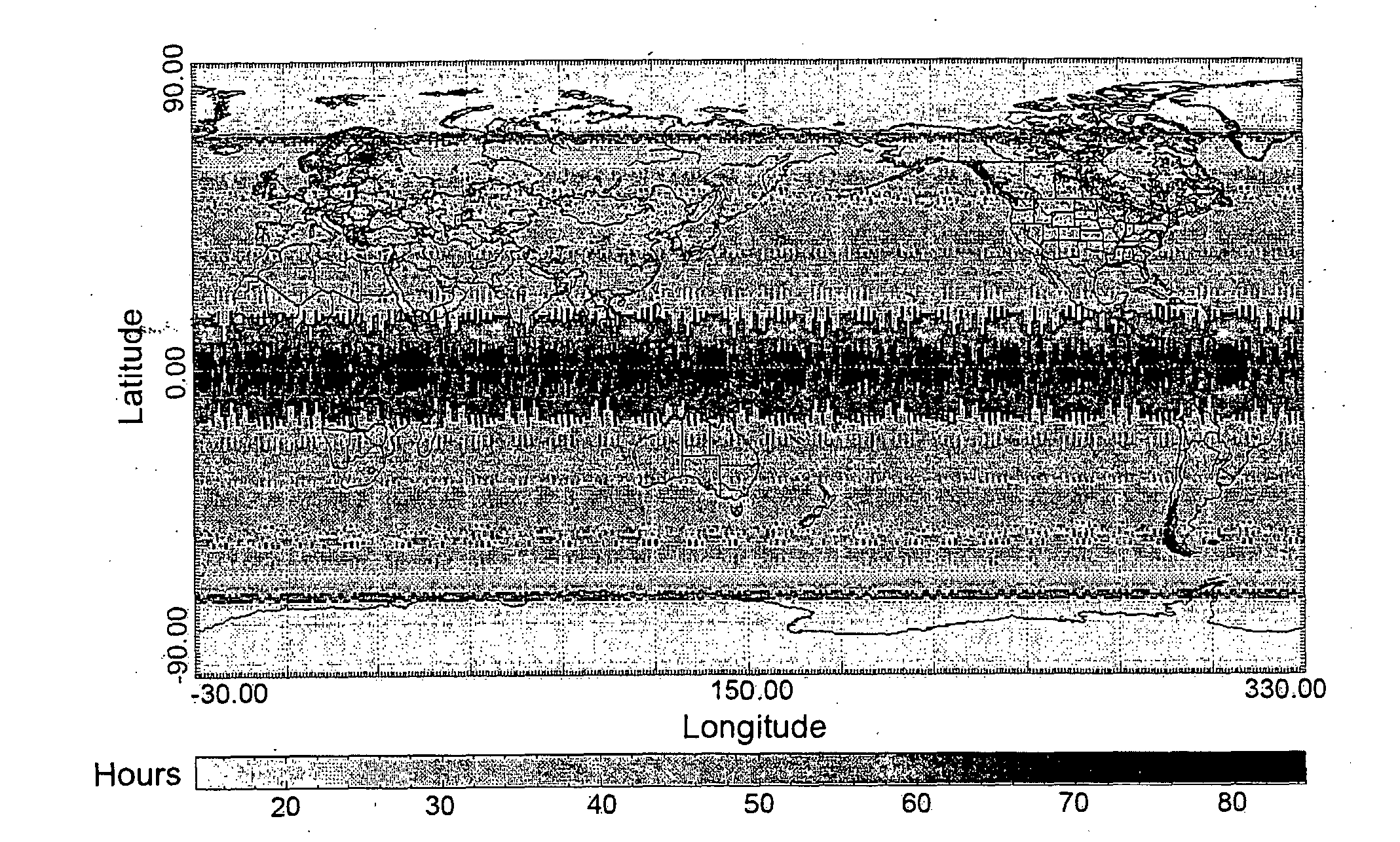
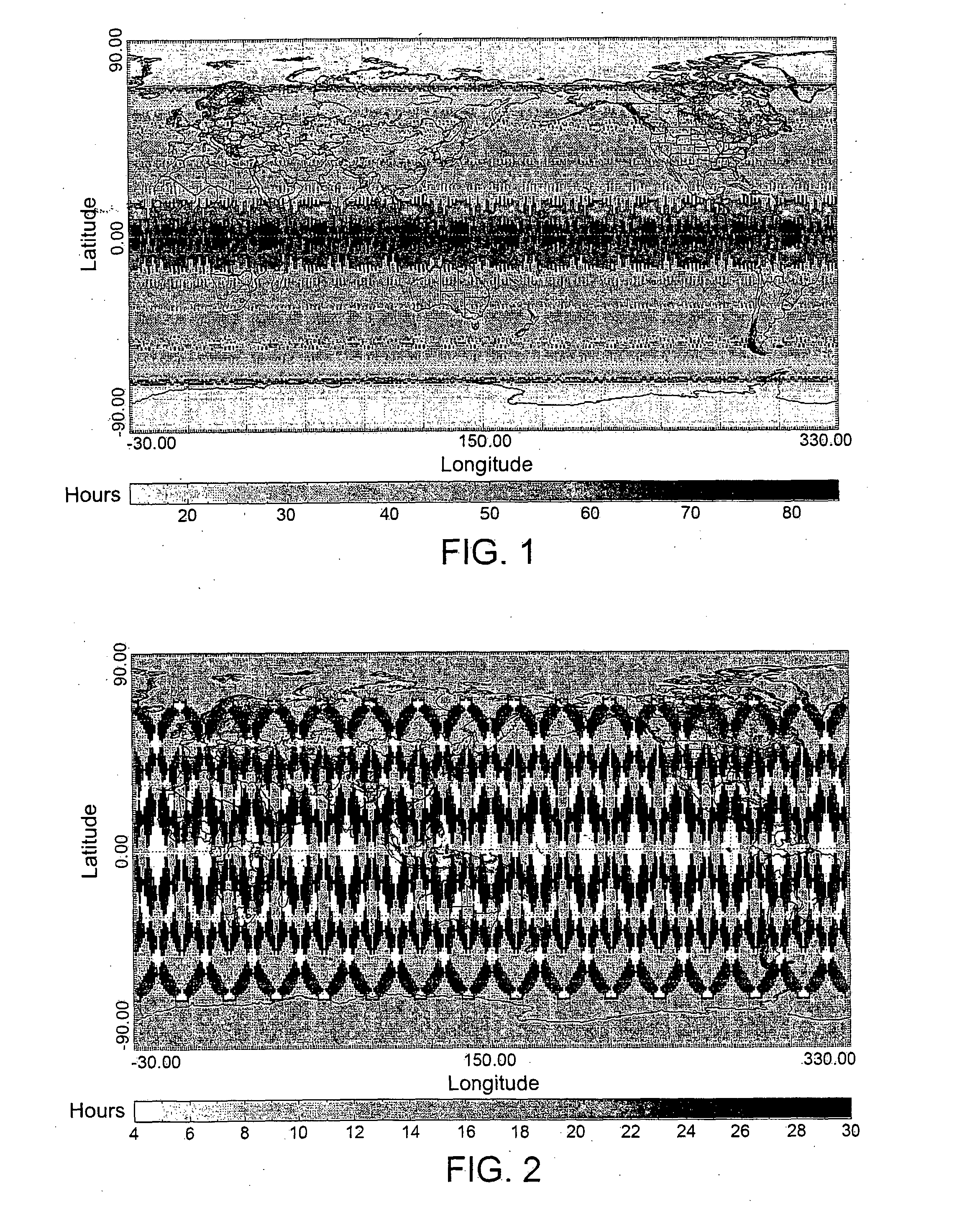
[0068]In order to better understand the differences between the time performance of the orbit design according to the present invention and that of traditional Earth observation systems, FIG. 1 shows the revisit times with respect to the Earth's surface of the TerraSAR-X satellite (which, as is known, is equipped with a SAR sensor), while FIG. 2 shows the revisit times with respect to the Earth's surface of an Earth observation system according to the present invention, in particular a system based on a single satellite having a polar sun synchronous orbit and a one-day orbital cycle.

[0069]As shown in FIG. 1, the revisit times of the TerraSAR-X satellite are between 60 and 84 hours in the regions around the equator and between 40 and 50 hours in medium latitude regions.

[0070]Conversely, the maximum revisit time of the above-stated Earth observation system according to the first embodiment of the present invention is obviously shortened to 24 hours by design. In particular, the non-a...

second embodiment

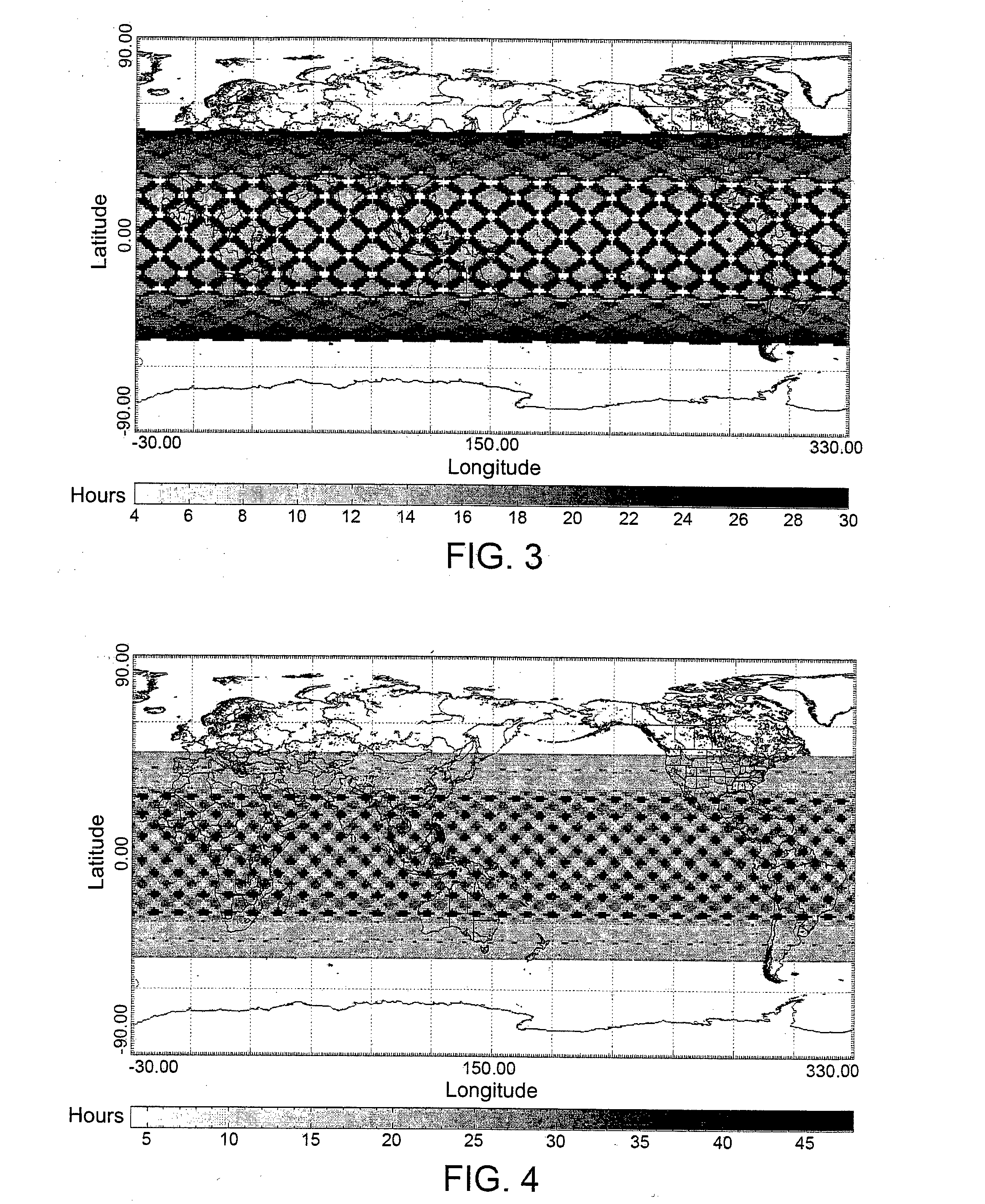
[0071]By using an inclined orbit it is still possible to ensure a maximum revisit time of 12-24 hours and it is also possible to optimize the resulting ground grid to obtain areas of predetermined size (for example, in the order of 2400×2400 Km2) such as to ensure complete coverage of the various states. With regard to this, FIG. 3 shows the revisit times with respect to the Earth's surface of an Earth observation system according to the present invention, in particular a system based on a single satellite equipped with a SAR sensor and having an inclined orbit and a one-day orbital cycle. In FIG. 3, it is evident how the coverage is more regular with respect to that shown in FIG. 2 and, above all, how this coverage in continuous in a band of medium latitudes.

[0072]Obviously, it is possible to optimize coverage over different geographic areas by altering the inclination of the orbit to improve coverage over the areas of interest.

[0073]The possibility thus ensues of the system being ...

third embodiment

[0087]To remedy these drawbacks, it is possible to choose an orbit with an orbital cycle of two days instead of just one. Obviously, in this case, the maximum revisit time rises to approximately 48 hours, but this orbital cycle ensures global access (in the case of an inclined orbit, global access within the chosen band of latitudes) and enables increasing the available number of angles of incidence (except for certain areas that are still characterized by just one access in the orbital cycle). With regard to this, FIG. 4 shows the revisit times with respect to the Earth's surface of an Earth observation system according to the present invention, in particular a system based on a single satellite equipped with a SAR sensor and having an inclined orbit and a two-day orbital cycle.

[0088]Obviously, by continuing to increase the orbital cycle, the maximum revisit time rises more and more until it becomes comparable to that of a traditional satellite remote sensing system, thereby losing...


PUM


Abstract

The invention concerns a method for reducing the costs of a satellite remote sensing service. The method comprises providing a satellite remote sensing system that includes only one satellite equipped with a sensor configured to acquire images of areas of the earth's surface, the satellite remote sensing system being designed to provide a satellite remote sensing service based on the images acquired by the sensor on board the satellite. In particular, the satellite follows a predefined orbit around the earth with an orbit repeat cycle shorter than three days, whereby a satellite remote sensing service with very good time performance, excellent interferometric capabilities and with drastically reduced costs is obtained.

Description

TECHNICAL FIELD OF INVENTION[0001]The present invention concerns an innovative orbit design that enables:[0002]providing a satellite remote sensing system based on, the use of a single satellite capable of ensuring time performance and interferometric capabilities comparable with those of a system based on the use of a constellation of satellites; and[0003]reducing the costs of design, development, testing, commissioning, operation, etc. of such a system and, consequently, also of the associated remote sensing service.STATE OF THE ART[0004]Within the field of Earth observation, due to their ability of continually acquiring data over vast regions everywhere on the Earth's surface, satellite remote sensing systems allow collecting large amounts of information on the Earth's surface of fundamental political, economic and environmental importance.[0005]As is known, satellite remote sensing is mainly based on the use of two types of sensor:[0006]passive sensors, such as optical and infra...

Claims


Application Information

Patent Timeline
Patent Type & Authority Applications(United States)
IPC IPC(8): G01S13/90B64G1/10B64G1/40G06F17/10
CPCG01S13/9023B64G1/405B64G1/1021G06F17/10B64G1/242G01S13/90B64G1/1035
Inventor DI GIORGIO, FABIOFRANCIONI, ANDREACRICENTI, ALESSANDRO
Owner THALES ALENIA SPACE ITAL SPA
Why Eureka
Try Eureka