Method and system for implementing navigation using bounded geograhic regions

a navigation and guidance system technology, applied in the direction of navigation instruments, instruments, location information based services, etc., can solve the problems of insufficient explicit solution, labor-intensive and time-consuming, and force-based implementation of navigation and guidance systems using bounded geographic regions (“bgrs”), so as to minimize the overall impedance of a navigational guidance sequence, improve system performance, and improve accuracy

Inactive Publication Date: 2016-10-06
RIGHTTHEREWARE
View PDF2 Cites 1 Cited by
  • Summary
  • Abstract
  • Description
  • Claims
  • Application Information

AI Technical Summary

Benefits of technology

[0022]The use of a NPLUT captures the historical traffic flow within each regular BGR in an area of interest. As a result, the average speed and instantaneous speed, versus time, is captured as a natural function of prior navigation and guidance. The historical traffic flow data can be used to predict more accurate values for average speed and instantaneous speed, versus time, between any two nodes. As a result, the BGR system learns quickly how to adjust the ETA and other cost functions related to speed, as they vary in a predictable, time-dependent fashion.
[0023]Since the cost function is varying in a predictable, time-dependent fashion, the traffic flow within each BGR can be represented as longitudinal eigenmode. This allows for modeling and data analysis using well-recognized modal methodologies, such as time-varying impedance, resonance, and quality factor. In this way, it is easy to identify geographic points that provide the biggest cost-function variance at a given time of day. To improve accuracy, the navigation kernel would avoid such geographic points of great variance, because these geographic points (e.g., a particular intersection at a particular time of day) are unpredictable, the system could route around them. Additionally, impedance can be related to the cost function. For example, impedance can be calculated with respect to time-of-arrival and time-of-day, speed and time-of-day, or fuel usage and time-of-day. As a result, impedance can be used as a proxy for the cost-function. By minimizing the overall impedance of a navigational guidance sequence, the system will be optimizing the cost-function
[0024]Areas of interest, regular BGRs, super BGRs, and historical traffic flow can be combined to create predictable behavior in a region during a special event, such as a sporting event or concert. The special event can also be a relatively pedestrian, recurrent, event, such as a local high school letting out at the same time on every school day. The impact that the special event has on the historical traffic flow is necessarily included in the NPLUT. By selecting a geographically appropriate flag (a flag that is attached to a BGR, group of BGRs, or super BGR), the impact of the special event can be predicted and accounted for in future navigation or guidance requests.
[0025]The error in the BGR navigation and guidance methodology is small, much smaller than other similar navigation kernels. The error that is inherent in the BGR navigation and guidance methodology is proportional to area. Therefore, to improve the system performance, it is desirable to reduce the overall area of the average regular BGR, to improve accuracy and reduce overall error. In the limit, such a reduction in BGR size could be nothing more than a pixel or other point representation. Clearly, there is a trade-off between the database size (smaller BGRs lead to a larger NPLUT) and the BGR size. The optimum solution is dependent on the efficiency of database methods (so-called big data methods) and the processing power of the system processor. By correctly constructing the NPLUT, with appropriate BGR and node naming conventions, as discussed, infra, it is possible, after the BGR system has been up and running, to revise the system to smaller BGRs, by simply sub-dividing the existing BGRs. The data in the original NPLUT would then be easily mapable to a new NPLUT.

Problems solved by technology

However, the brute-force implementation of a navigation and guidance system using Bounded Geographic Regions (“BGRs”) is both labor-intensive and time-consuming.
Specifically, the proper set-up of the BGRs with respect to a mapping database can be both labor-intensive and time-consuming.
In practice, these first two requirements cause problems, because the curvature of the Earth causes variation of either the aspect ratio or the area.
Furthermore, an explicit solution is not necessarily guaranteed in attempting to simultaneously create BGRs over a very large region.
This problem is caused because trying to overlay BGRs onto a large geographic region creates a very large number of degrees of freedom.
In other words, using a brute force method to try and overlay the Earth with BGRs can lead to repeated unacceptable solutions.
Although a computer can be compiled with an adequate instruction set to keep searching until an acceptable solution is found, it can take a significant amount of time (days, weeks, or months, depending on the processing power employed).
The scale and scope of partitioning the Earth causes this problem, with BGRs of a reasonable area numbering easily into the millions or tens-of-millions.
The problems can lead to either repeated unacceptable solutions, or to an inordinately long processing time.

Method used


Image

  • Method and system for implementing navigation using bounded geograhic regions
  • Method and system for implementing navigation using bounded geograhic regions
  • Method and system for implementing navigation using bounded geograhic regions

Examples


Embodiment Construction

[0040]This description is not meant to limit the invention, but rather to illustrate its general principles of operation. Examples are illustrated with the accompanying drawings.

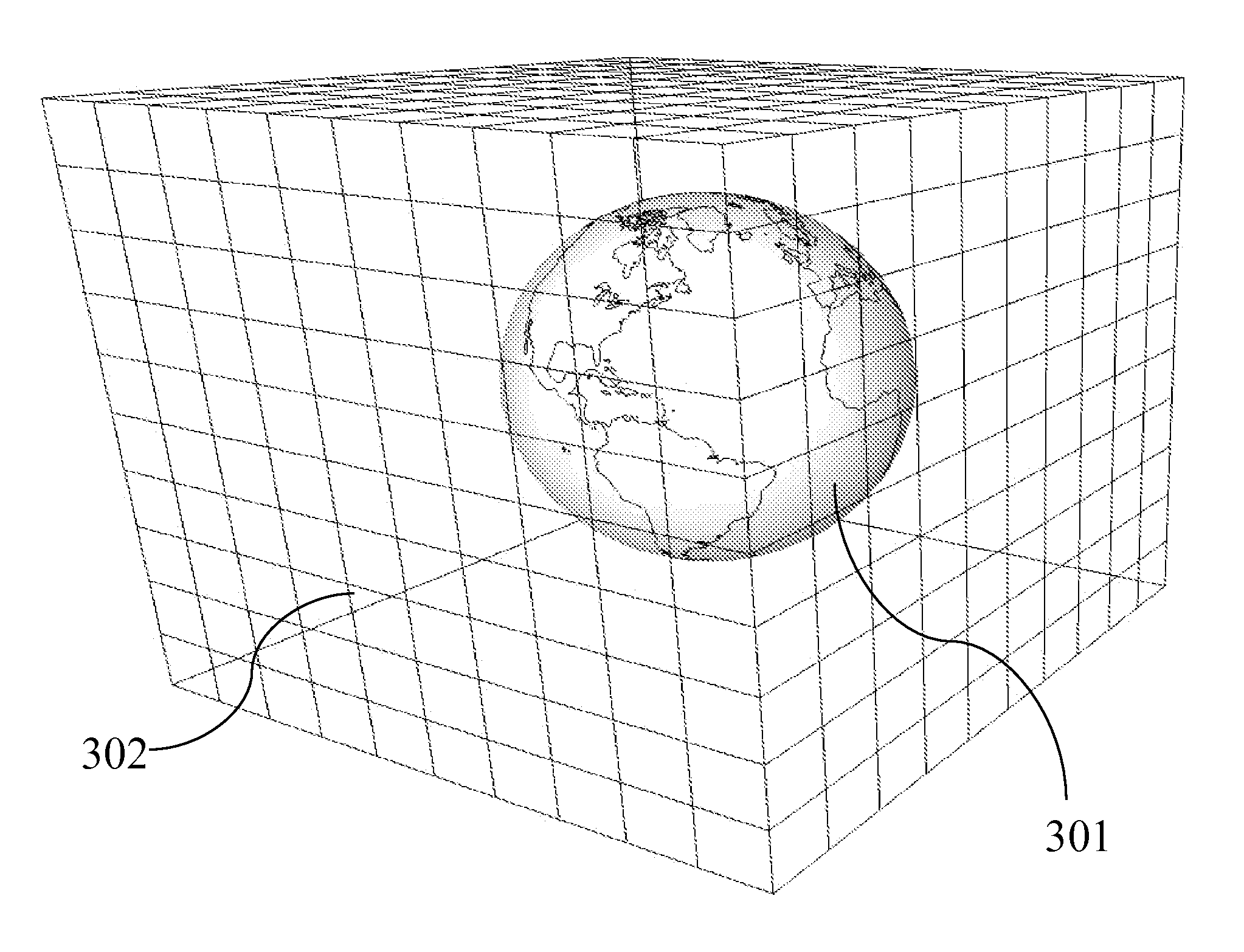
[0041]In U.S. Utility Pat. No. 8,868,332, METHOD AND SYSTEM FOR NAVIGATION USING BOUNDED GEOGRAPHIC REGIONS; and U.S. Pat. No. 8,775,059, METHOD AND SYSTEM FOR MULTI-VEHICLE, MULTI-DESTINATION ROUTING, a system and method for navigation and multi-vehicle navigation, using BGRs, was disclosed.

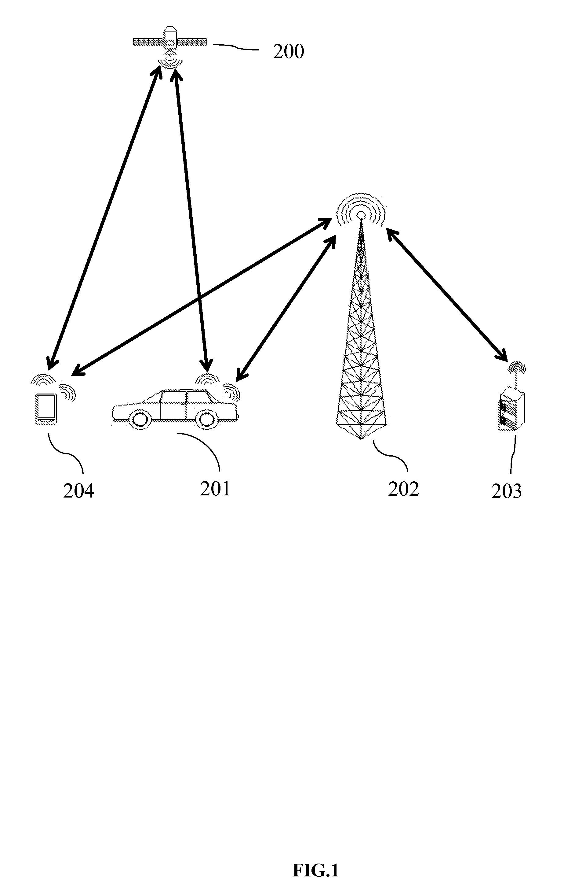
[0042]FIG. 1 shows an embodiment of wireless communication and geo-location, which is necessary for navigation. The end user is in a vehicle 201, which has a remote electronic device (“RED”), either built-in or mounted. The vehicle 201 geo-locates via a GPS chip-set, a gyro, and / or a satellite transceiver. A plurality of satellites 200 provides GPS signals to the vehicle's 201 GPS transceiver. The vehicle 201 is then able to communicate its location to a central server 203, using a wireless network 202. The wireless netw...


PUM


Abstract

A method and system for creating Bounded Geographic Regions (“BGRs”) in a navigation system using BGRs is presented. Various methods for creating BGRs are disclosed. Additionally, the implications of minimizing the area of a BGR is discussed and disclosed. The method and system allows for easier convergence for creation of BGRs.

Description

FIELD OF INVENTION[0001]This invention relates to the field of navigation route calculation and guidance, including hand-held navigation, in-vehicle navigation, server-based navigation, and cell-phone application-related navigation.BACKGROUND OF INVENTION[0002]Information on the Background of this invention can be found in U.S. Utility Pat. No. 8,868,332, METHOD AND SYSTEM FOR NAVIGATION USING BOUNDED GEOGRAPHIC REGIONS; and U.S. Pat. No. 8,775,059, METHOD AND SYSTEM FOR MULTI-VEHICLE, MULTI-DESTINATION ROUTING. This patent application will refrain from repeating the adequate Background described in its predecessor patents.[0003]Navigation kernels which pre-existed the use of Bounded Geographic Regions (“BGRs”) had several performance deficiencies, namely inaccurate estimated time of arrival (“ETA”), and sub-optimum routing. A navigation kernel using BGRs can overcome many of these deficiencies, as described in the two above referenced patents.[0004]However, the brute-force implemen...

Claims


Application Information

Patent Timeline
Patent Type & Authority Applications(United States)
IPC IPC(8): G01C21/34H04W4/021
CPCG01C21/34G01C21/3461H04W4/021
Inventor HEED, JOHN CULVERHEED, THOMAS PAUL
Owner RIGHTTHEREWARE
Why Eureka
Try Eureka