Method for extracting elevation control point with assistance of satellite laser altimetry data

a laser altimetry and satellite technology, applied in the field of high-resolution photogrammetry and remote sensing, data matching and registration, multi-source remote sensing data joint processing, etc., can solve the problems of difficult to extract the elevation of a specific point in complex terrain from laser altimetry data, and the difficulty of laser altimetry data being used directly for large-scale terrain acquisition, etc., to improve the accuracy of 3d reconstruction and improve the effect of elevation accuracy

Inactive Publication Date: 2020-04-02
CHINESE ACAD OF SURVEYING & MAPPING
View PDF18 Cites 13 Cited by
  • Summary
  • Abstract
  • Description
  • Claims
  • Application Information

AI Technical Summary

Benefits of technology

[0035]Step 11. Extraction of elevation control points for remote sensing images: Translate the 3D coordinates without local DSM system error correction to image coordinates with geometric model using the preliminarily refined orientation parameters of stereo or InSAR images. The image point coordinates and the corrected elevation value are constitute image elevation control points, which could be used for image geometry processing and improving ele

Problems solved by technology

However, the laser spot positioning plane error and the laser spot diameter is usually large.
It is difficult to extract the elevation of a specific point in complex terrain from the laser altimetry data.
At the same time, the spot distribution is sparse and uneven, so the laser altimetry data is difficult to use directly for large-scale terrain acquisition currently.
Due to the error of image target, laser remote sensing target localization and the differences i

Method used


Image

  • Method for extracting elevation control point with assistance of satellite laser altimetry data
  • Method for extracting elevation control point with assistance of satellite laser altimetry data

Examples


Embodiment Construction

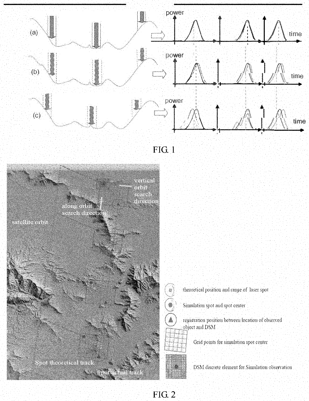
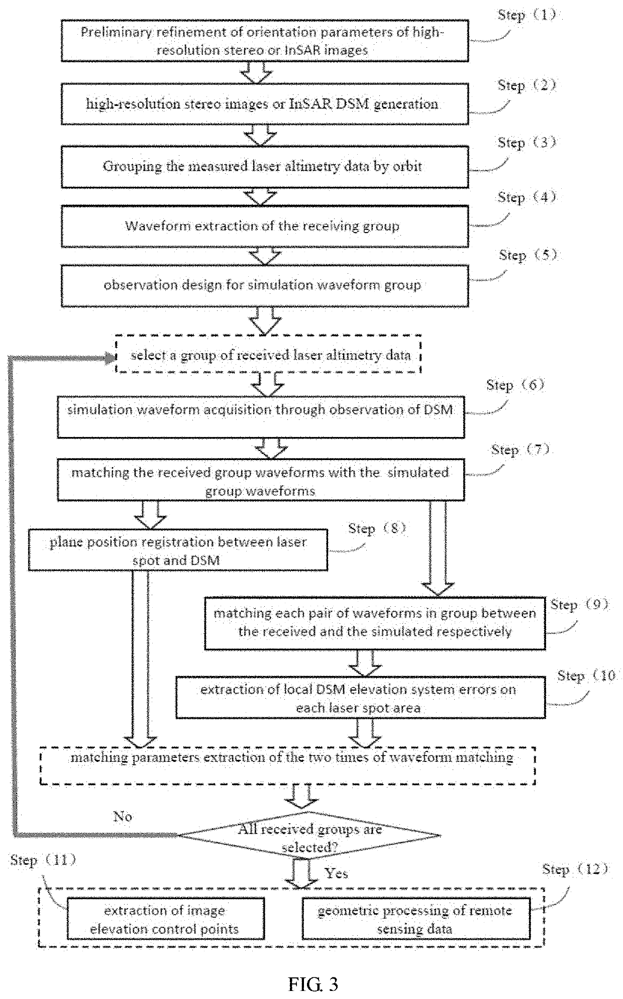
[0018]The registration between location of observed object of laser altimetry and DSM is realized by matching with group waveforms as a whole. That is, take a section of orbit laser altimetry waveforms as a whole, and convert the registration between locations of observed object of laser altimetry and DSM into matching of received group waveforms and group waveforms simulated with DSM. Then convert elevation system error calculation of each local DSM of the spot area into the matching of the received waveform and the simulated waveforms. The core process of the invention consists of two times of waveform matching and can be extended to the following steps:

[0019]Step 1. Preliminary refinement of orientation parameters of high-resolution stereo images or InSAR: refine the orientation parameters of high-resolution stereo images or InSAR images by the technology of block adjustment or free net adjustment, the preliminarily refined orientation parameters are used for the subsequent steps...


PUM


Abstract

A method of elevation control points extraction assisted by satellite laser altimeter data, which is characterized in that take the waveforms received by satellite and the waveforms simulated from digital surface model (DSM) of image scene reconstruction as input data, and includes two times of waveform matching and combined process of multi-source remote sensing data. The elevation control points could be extracted without the influence of terrain fluctuation or urban buildings for the terrain information of laser spot area has been taken into account. The first time is realized by matching two groups of waveforms from the received and the simulated, and the spatial registrations between locations of laser spots and DSM are realized. The second time is realized by matching two single waveforms from the received and the simulated, and local system errors in DSM of laser spot area could be extracted. With the registration results and local system errors, many applications including extraction of elevation control points could be easily developed. The invention mainly includes the following steps: (1) Preliminary refinement of orientation parameters of high-resolution stereo or InSAR images by free net adjustment; (2) DSM reconstruction with high-resolution stereo images or InSAR data; (3) dividing the received laser altimetry data into groups; (4) Waveform extraction of the receiving group; (5) observation design for simulation waveform group; (6) simulation waveform acquisition through observation of DSM; (7) matching the received group waveforms with the simulated group waveforms; (8) plane position registration between laser spot and DSM; (9) matching each pair of waveforms in group between the received and the simulated respectively; (10) extraction of DSM elevation system errors on each laser spot area; (11) extraction of image elevation control points; (12) refinement of DSM elevation, calibration of satellite laser altimeter sensor, combined processing with laser altimetry and image remote sensing. The invention mainly solves two difficulties. One difficulty is finding footprints, or say laser spot areas, of satellite laser altimeters on stereoscopic images, InSAR images and the DSM they generate. Another difficulty is the accurate elevation extraction of laser spot areas with uneven terrain. The invention can realize the spatial registration between laser spot and DSM or remote sensing in different terrain and establish spatial connection between laser altimetry data and stereo images or InSAR data. In different terrain conditions, by the invention, the satellite laser altimetry data can be used for high-precision elevation control of 3D reconstruction/positioning of stereo images or InSAR data.

Description

RELATED APPLICATION(S)[0001]This application is a continuation of International Application No. PCT / CN2018 / 089914, which designated the United States and was filed on Jun. 5, 2018, published in Chinese, which claims priority under 35 U.S.C. § 119 or 365 to Chinese Application No. 201710413046, filed on Jun. 5, 2017. The entire teachings of the above applications are incorporated herein by reference.FIELD OF THE INVENTION[0002]The invention relates to high-resolution photogrammetry and remote sensing, data matching and registration, and multi-source remote sensing data joint processing and other fields. The invention focuses on the spatial matching and registration methods of laser altimetry data and DSM and image data.BACKGROUND OF THE INVENTION[0003]The research on satellite radar altimetry technology is mainly concentrated in some developed countries such as the United States and Europe, while in other countries, the development of the technology in developing countries is relativ...

Claims


Application Information

Patent Timeline
IPC IPC(8): G01S17/894G01S17/90G01S7/48
CPCG01S7/4808G01S17/894G01S17/90G01S17/88G01S7/295G01S17/89G01S7/4026G01S13/865G01S13/9023G06T17/05G06T2207/10072G06T2207/10032
Inventor CHENG, CHUNQUANZUO, ZHIQUANHUANG, GUOMANZHANG, JIXIANZHANG, LIWEN, HANJIANG
Owner CHINESE ACAD OF SURVEYING & MAPPING
Why Eureka
Try Eureka