Method of and apparatus for analyzing images

a technology of image and apparatus, applied in the field of methods and apparatus for analyzing images, to achieve the effect of preventing memory conflicts and reducing safety distan

Active Publication Date: 2021-02-11
FUGRO
View PDF13 Cites 11 Cited by
  • Summary
  • Abstract
  • Description
  • Claims
  • Application Information

AI Technical Summary

Benefits of technology

[0029]Accordingly the present invention also provides an apparatus as defined in claims 1-7, wherein an image of elements is processed in order to assign labels to the different elements wherein these labels expressed neighbourhood relations among the elements. The image domain is divided into smaller quadrants, called nodes, the labelling process can be optimized and executed in parallel in multiple cores of a GPU, for instance. This is due to the fact that the nodes can be processed independently and therefore, in parallel. After each node is processed, it is merged together with other adjacent nodes. This process is repeated iteratively until every node has been checked against all its adjacent nodes. In order to process the nodes in parallel, the data structures that hold the labels of the nodes are organized such that memory conflicts are prevented.
[0030]Furthermore, the present invention provides an apparatus and method as defined in claims 23-30. High-accuracy GNSS positioning allows to reduce the safety distance between the target and the chaser down to a few meters, thereby removing the need for sophisticated large or high-resolution cameras for the chaser, or the amount of power required for the Light Emitting Diodes (LEDs) in the target. The light transmission of GNSS data allows to re-use the vision system for both navigation and communication. In this way additional payloads are avoided on-board. Furthermore, the combination of both a high-accuracy GNSS and a vision system allows to detect a risk for the integrity of the spacecrafts when the relative distance computed separately from the vision system and the GNSS data do not agree. This real-time check between two independent sensors allows to automatically abort the rendezvous manoeuvre in case a collision risk is detected.

Problems solved by technology

This position / orientation algorithm is rather complex and it does not allow for an efficient parallelization and use of the memory in order to reduce the computing time and the resource consumption.
Once again, the recursive nature of this process for calculating the position / orientation is time and resource consuming and does not allow for an efficient parallelization and resource allocation.
However, A LIDAR device is very expensive.
That means it requires specialists to perform the survey and, for bigger structures, it is hard to acquire imagery from all required sides of the structure.
However, a laser striper can only 3D reconstruct a single stripe and it needs to be installed on an accurate rotation stage, resulting in similar disadvantages as using a LIDAR device.
However, as photogrammetry, the results could be biased and inaccurate without proper planning.
Structured light or Time of Flight (TOF) cameras show similar disadvantages as a structured-light 3D scanner.
However, total station is expensive and the measured points need often to be prepared with reflective tape or prisms.
Using tape measure is cumbersome and often not applicable to get full 3D offsets.
GPS only works in outside environments and cannot reach every spot.
Also standalone GPS accuracy without augmentation is not reliable.
Finally, extracting points from the cloud obtained using any of the previous 3D scanning techniques shows similar draw backs as it has been explained and the additional burden to have to process pick points manually from the data.
However, a robotic total station can only track small movements in a low update rate with the risk of losing track of the prism that is tracked, requiring manual intervention to re-initialize, and GPS only works outside with limited accuracy (typically meter-level accuracy, but can get significantly worse in case of marginal signal tracking conditions)
Furthermore, extra sensors on the to-navigate vessel are needed, which can be expensive, require extra power and an extra datalink.
However, the current state-of-the-art techniques have a number of limitations:Standalone GNSS positioning is not accurate enough when the distance is below 10 meters, and therefore GNSS-only positioning can be used only up to a significant distance to the target (for instance more than 100 meters) for safety reasons.The limited absolute GNSS accuracy imposes a requirement such that a high-performance optical camera is required for a chaser spacecraft to identify a target's spacecraft position using only a vision-based system.A single-sensor system (either based on GNSS or vision) cannot entirely provide integrity information due to estimation errors that cannot be easily quantified in real-time.The transmission of GNSS data from the target spacecraft to the chaser spacecraft typically requires a Radio Frequency (RF) inter-satellite communication link thereby resulting in additional power, additional antenna elements and extra weight for both the chaser and the target spacecrafts.

Method used


Image

  • Method of and apparatus for analyzing images
  • Method of and apparatus for analyzing images
  • Method of and apparatus for analyzing images

Examples


Embodiment Construction

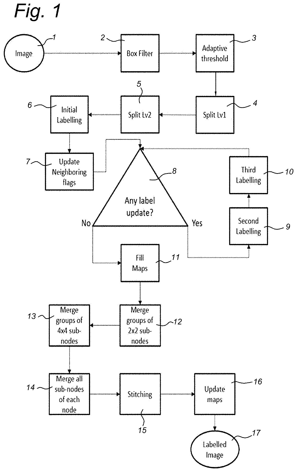
[0054]The present invention provides a method and a device for analyzing an image for pattern identification. The invention also relates further to a method of and apparatus for performing tracking or positioning of an object based on a pattern in an image which pattern is fixed to that object. The invention also relates to a method of and an apparatus for allowing autonomous rendezvous and docking of two objects like two spacecrafts where one of the objects has a pattern fixed to it.

[0055]The pattern is a dot pattern like the ones shown FIGS. 10, 12 and 13. The patterns used have specific features as will be explained hereinafter. In general, an image of the dot pattern will be made by a camera having a suitable image sensor, e.g., a 2D sensor array. The image signal as generated by this sensor is output to a suitable processing system which processes the image signal in a way as defined hereinafter. A general setup of examples of such a camera with processing system is shown in an...


PUM


Abstract

Apparatus for determining a spatial property in a 3D-space, wherein the apparatus comprises a physical pointer, a camera and a position and orientation measurement system, wherein a first object in the 3D-space comprises a pattern on it, wherein the physical pointer is configured to contact a surface area of a second object in the 3D-space, wherein the camera is configured to capture, at a position of the camera with respect to the first object, image data comprising an image of the pattern; wherein the position and orientation measurement system is configured to determine a heading, position, verticality, attitude, and/or inclination of the camera based on the image of the pattern, and determine, based on the determined heading, position, verticality, attitude, and/or inclination of the camera and a relative position of the physical pointer with respect to the camera, the spatial property of the surface area by the physical pointer.

Description

FIELD OF THE INVENTION[0001]The present invention relates to a method of and apparatus for analyzing an image. The invention relates further to a method of and apparatus for performing tracking or positioning of an object based on a pattern in one or more images. The invention relates as well to a method of an apparatus for 3D scanning based on a pattern. Furthermore, the invention relates to a method of and an apparatus for allowing autonomous rendezvous and docking of two objects like spacecrafts.BACKGROUND ART[0002]EP1596331 discloses a position / orientation determination unit for determining a position and an orientation of an imaging device including an image input unit, a data memory, an index detector, an orientation sensor unit, an orientation prediction unit, and a position / orientation calculator, wherein indices to be shot by the imaging device are arranged at a plurality of positions in a real space and wherein the position / orientation calculator receives a predicted orien...

Claims


Application Information

Patent Timeline
Patent Type & Authority Applications(United States)
IPC IPC(8): G06K9/00G06T7/187G06T7/70G06T7/80
CPCG06K9/00624G06T7/187G06T2207/10028G06T7/80G06T2207/20221G06T7/70G06T2207/20021
Inventor DIAS BISPO CARVALHO, DIEGOSCHIPPERS, EVERTJONGSMA, ARNOUD MARCPASTERNAK, MICHALTEGEDOR NAVARRO, FRANCISCO JAVIER
Owner FUGRO
Why Eureka
Try Eureka