Borehole survey method utilizing continuous measurements

a survey method and borehole technology, applied in the field of borehole survey method utilizing continuous measurements, can solve the problems of inability to measure depth, unpredictably influence the trajectory of a drilled borehole, and substantial errors in calculating the vertical depth and position of a survey station of interest, so as to improve the accuracy of estimation, eliminate or reduce errors, and improve the accuracy of borehole spatial and positional computations

Inactive Publication Date: 2003-10-14
SCHLUMBERGER TECH CORP
View PDF20 Cites 38 Cited by
  • Summary
  • Abstract
  • Description
  • Claims
  • Application Information

AI Technical Summary

Benefits of technology

The present invention provides a borehole survey method that utilizes continuous measurements of the earth's magnetic and gravitational fields obtained while actively drilling the borehole. The continuously obtained survey data is transmitted to the surface using mud telemetry systems. The continuously obtained survey data may be processed using downhole micro processors, or it may be first transmitted to the surface and there processed using computers to refine the data and eliminate or reduce error from unwanted shock, vibrations and nose from drilling. The present invention improves the accuracy of borehole spatial and positional computations by improving the accuracy of estimations of borehole vertical depth and position using integration of borehole surveys.
The objective of the present invention is to augment existing methods of modeling a drilled borehole, such as the minimum radius of curvature calculation, with effective estimates of the earth's magnetic and gravitational fields obtained by processing measurements obtained while drilling. In one method of the present invention, a log of continuous azimuth and continuous inclination data is created, and the log is divided into sections delineated in time by discrete survey stations. The measurements of the earth's magnetic and gravitational data within these delineated sections are then smoothed using windowed median smoothing to eliminate random noise caused by shock and vibration. Mathematical interpolation between adjacent smoothed magnetic and gravitational field measurements, or between adjacent smoothed azimuth and inclination data derived from magnetic and gravitational field measurements, is performed to determine a synthetic azimuth and inclination corresponding to a desired depth of interest corresponding to a survey station. The synthetic magnetic and gravitational field measurements, or the azimuth and inclination derived therefrom, is compared to the more reliable measurements of magnetic and gravitational fields obtained at survey stations in order to determine an offset correction, which is then used to adjust the continuously obtained magnetic and gravitational field measurements. Existing methods, such as the minimum radius of curvature calculation, may then be used to process the corrected measurements, and the resulting spatial and positional computations provide superior direction of the borehole to the desired target.

Problems solved by technology

Many factors may combine to unpredictably influence the trajectory of a drilled borehole.
Although the azimuth and inclination at a survey station of interest can be determined using measurements of the earth's magnetic and gravitational fields, the depth cannot be measured, and must be determined by other means.
The problem is that undetected borehole variations occurring between discrete survey stations cause substantial errors in calculating the vertical depth and position of a survey station of interest.
The inability of these existing borehole survey methods to detect and account for borehole deviations that occur between survey stations is problematic.
Existing methods of surveying boreholes, including the minimum radius of curvature method, introduce significant error that lead to inaccurate determinations of borehole vertical depth and position resulting in substantial losses of otherwise recoverable reserves due to inaccurate steering of directional boreholes.
Borehole surveys using existing survey methods to model the trajectory of borehole segments between survey stations introduce substantial vertical depth and position error, and the extent of the error depends on the extent to which undetectable borehole variations occur between survey stations.
The problem is that the violent crushing and grinding of the drill bit against rock at the bottom of the borehole, the irregular interaction of the drillstring with the walls of the borehole, and even the constantly changing stresses in the connections between joints of drillpipe, all present during drilling operations, combine to contribute noise, shock and vibrations that severely contaminates continuously obtained measurements of the earth's magnetic and gravitational fields to the extent that this data is not useful in reliably determining the azimuth and inclination of the borehole at points between survey stations.

Method used


Image

  • Borehole survey method utilizing continuous measurements
  • Borehole survey method utilizing continuous measurements
  • Borehole survey method utilizing continuous measurements

Examples


Embodiment Construction

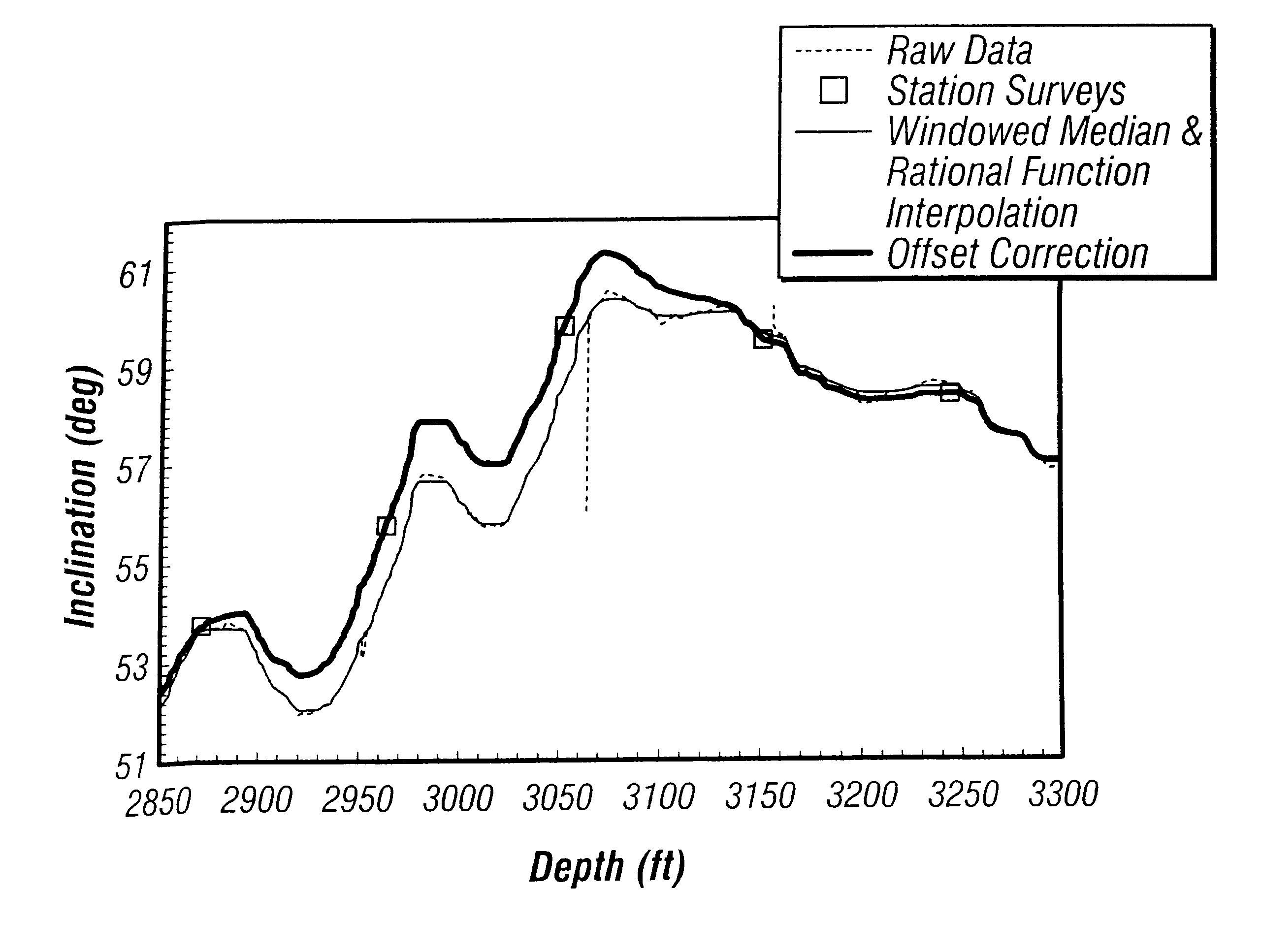
The present invention provides a method of processing either continuously obtained raw magnetic and gravitational field measurements or, in the alternative, azimuth and inclination estimates obtained using continuously obtained magnetic and gravitational field measurements made during the drilling of a borehole. "Azimuth data," "inclination data" and "azimuth and inclination data," as those terms are used herein, mean either the raw measurements of the earth's magnetic and gravitational fields or the estimates of borehole azimuth and inclination obtained using such raw measurements of the earth's magnetic and gravitational fields. It is within the scope of this invention to either process the raw magnetic and gravitational field measurements obtained during drilling of a borehole, or to process estimates of azimuth and inclination of the borehole obtained from raw magnetic and gravitational field measurements. The present invention can be effectively used in either case, and the dec...


PUM


Abstract

A borehole survey method is provided for processing continuous measurements of the earth's magnetic and gravitational fields obtained while drilling a borehole. The present invention improves borehole acquisition of targeted geological structures by substantially reducing continuous measurement errors attributable to noise, shock and vibrations from turning the drill bit against rock.< / PTEXT>

Description

This invention relates generally to making downhole measurements during the drilling of a borehole to recover natural deposits of oil or gas and, more particularly, to using continuous downhole measurements to directionally drill the borehole.DESCRIPTION OF THE RELATED ARTOil and gas are commonly recovered from natural mineral deposits in subsurface geologic formations in the earth's crust. Drilling rigs at the surface are used to bore long, slender boreholes into the earth's crust to the location of the subsurface oil or gas deposits to establish fluid communication with the surface through the drilled borehole. The downhole drilling equipment used to drill boreholes may be directionally steered to known or suspected oil or gas deposits using directional drilling techniques, and the direction and orientation of downhole survey instruments are monitored at discrete survey stations along the borehole.Surveying of boreholes is commonly performed using downhole survey instruments. Thes...

Claims


Application Information

Patent Timeline
Patent Type & Authority Patents(United States)
IPC IPC(8): E21B47/022E21B47/02
CPCE21B47/022
Inventor SHIRASAKA, ICHIROPHILLIPS, WAYNETEJADA, MAURICIO
Owner SCHLUMBERGER TECH CORP
Why Eureka
Try Eureka