Method of and system for deriving inertial-aided deviations for autoland systems during GPS signal interruptions

a technology of inertial aid and autoland system, which is applied in the direction of navigation instruments, using reradiation, instruments, etc., can solve the problems of ils signals being sensitive to local building construction, equipment is expensive, and only practical ils signals

Inactive Publication Date: 2005-01-18
ROCKWELL COLLINS INC
View PDF2 Cites 28 Cited by
  • Summary
  • Abstract
  • Description
  • Claims
  • Application Information

AI Technical Summary

Benefits of technology

[0013]Still another exemplary embodiment relates to a system for deriving inertial-aided deviations for autoland systems during GPS signal interruptions. The system includes a first component for generating global positioning positions, a second component for generating inertial reference system positions, a third component for generating calibrated positions based on the global positioning positions and the inertial reference system positions using a third-order calibration filter and a second-order calibration filter, and a fourth component for providing airplane control signals using deviation computations from the calibrated positions when the calibration filters converge.

Problems solved by technology

ILSs are only practical at airfields that have large incomes generated by commercial traffic or government finding because ILS equipment is costly due to initial purchase price and maintenance costs.
Also, ILS signals are sensitive to local building construction and even vehicle movement.
This sensitivity increases operating costs, because the ILS operators, such as the Federal Aviation Administration (FAA), must continually ensure each ILS is producing an accurate signal.
Even when the satellite geometry supports the required continuity and integrity, the signals received by airplanes are subject to environmental threats, such as electromagnetic interference (EMI) (both accidental and malicious), lightning and ionospheric scintillation (i.e., brown-outs associated with sunspot activity).
There is also the threat of random satellite failures and satellites setting over the horizon.
These threats can affect the reception of some or all of the available satellite signals, resulting in degradation or loss of guidance.
During GPS signal interruption, positional deviations from the desired flight path cannot be computed and provided to the autoland system by the GLS.
However, the GPS signal interruption can be as long as one or two minutes, which is much longer than the tolerable coasting time by autoland systems.
As such, GPS signal interruptions for more than 10 seconds pose a problem in terms of continuity for the CAT II / III autoland systems.
This approach places an added burden on the airborne equipment and has complex political implications.
Similar to ILS, this approach is impractical, because it entails large equipment expenditures and maintenance costs in addition to those of the differential GPS ground station.
Also, neither of these approaches adequately addresses the environmental and other threats described above, which may produce unreliable GLS data for an indefinite period of time.
There are limitations, though, to this algorithm.

Method used


Image

  • Method of and system for deriving inertial-aided deviations for autoland systems during GPS signal interruptions
  • Method of and system for deriving inertial-aided deviations for autoland systems during GPS signal interruptions
  • Method of and system for deriving inertial-aided deviations for autoland systems during GPS signal interruptions

Examples


Embodiment Construction

s for an exemplary coordinate conversion process;

[0020]FIG. 6 is a diagram illustrating processing operations for exemplary calibration and coasting processes using a third-order filter in accordance with an exemplary embodiment; and

[0021]FIG. 7 is a diagram illustrating processing operations for exemplary calibration and coasting processes using a second-order filter in accordance with an exemplary embodiment.

DETAILED DESCRIPTION OF EXEMPLARY EMBODIMENTS

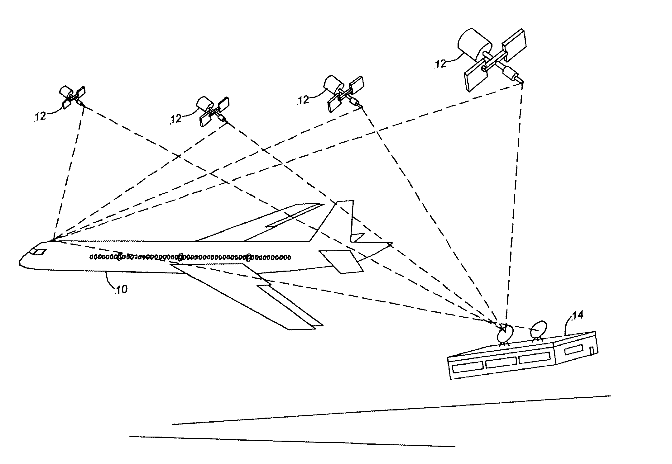
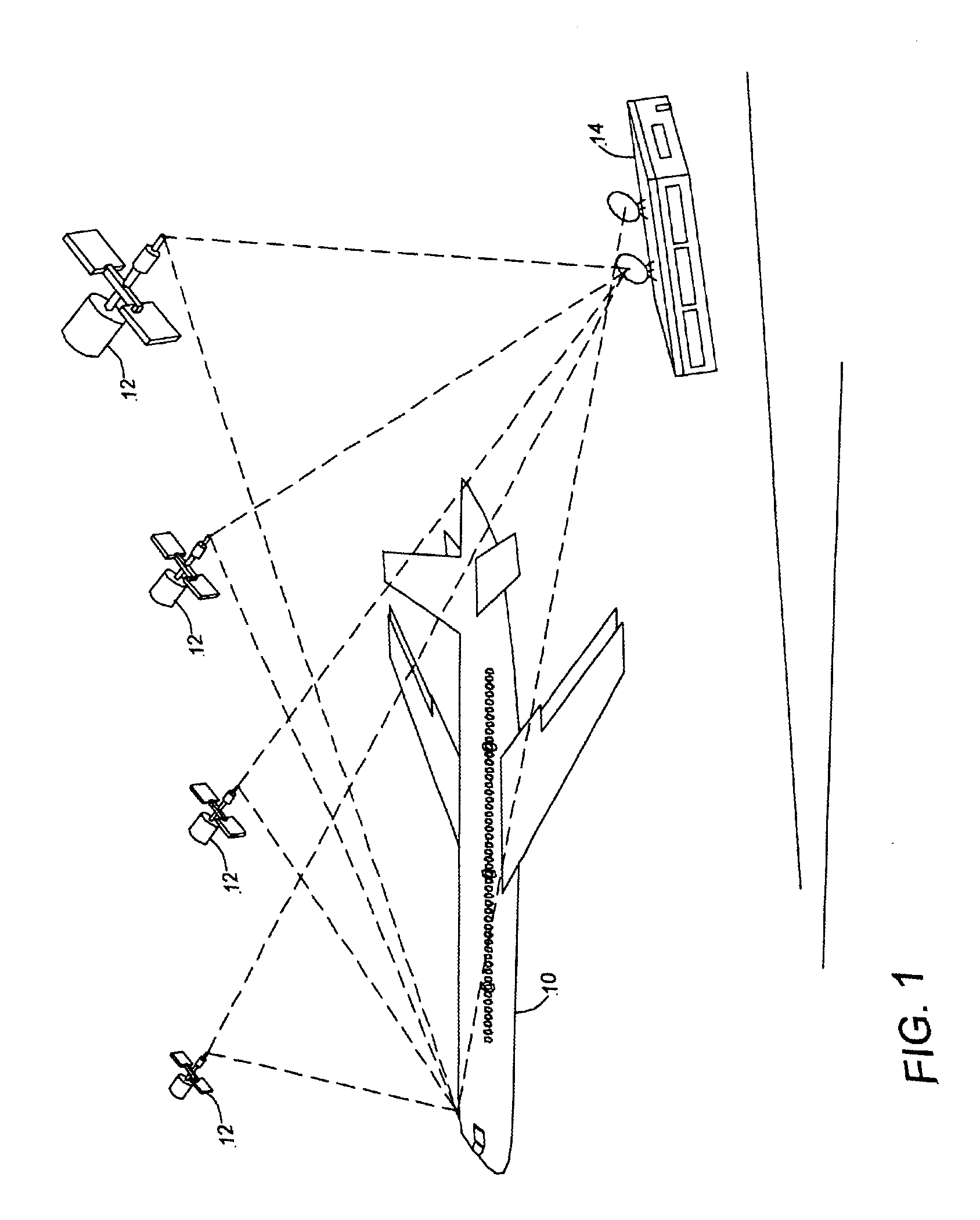
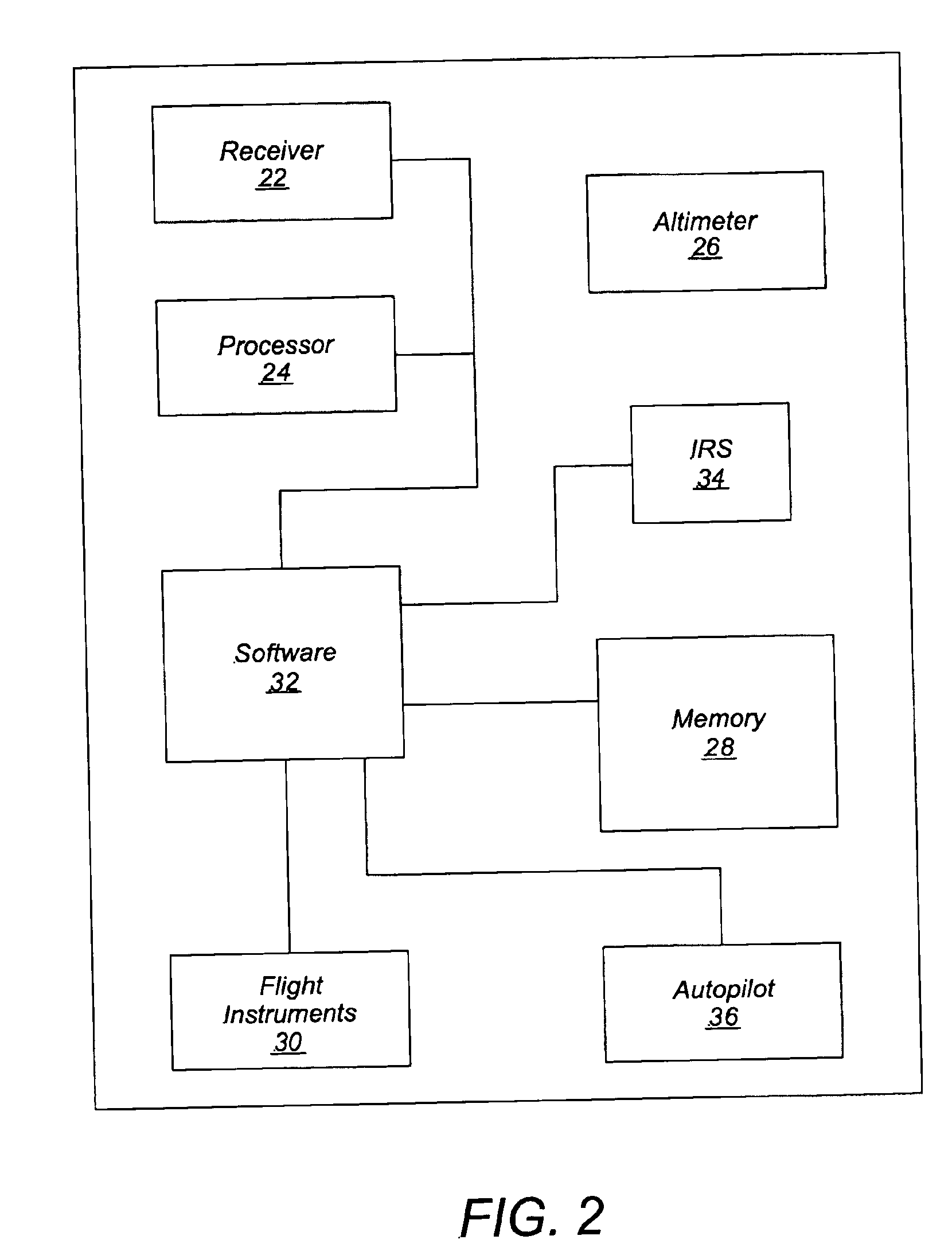
[0022]Referring to FIG. 1, an exemplary airplane precision approach guidance system including a Global Positioning System (GPS) Landing System (GLS) augmented with an Inertial Reference System (IRS) is provided in an aircraft 10. In the following description, for purposes of explanation, numerous specific details are set forth to provide a thorough understanding of exemplary embodiments of the invention. It will be evident, however, to one skilled in the art that the invention may be practiced without these specific details. In othe...


PUM


Abstract

Deriving inertial-aided deviations for autoland systems during GPS signal interruptions involving an inertial reference system and a GPS landing system can include converting position coordinates of an aircraft from the inertial reference system to runway, lateral, and vertical coordinates. After this conversion, the method calibrates runway distance and lateral distance based on the converted position coordinates from the inertial reference system using runway distance and lateral distance from the GPS landing system with a third-order calibration filter when the aircraft is below a first height above terrain and calibrates vertical distance based on the converted position coordinates from the inertial reference system using vertical distance from the GPS landing system with a second-order calibration filter when the aircraft is below the first height above terrain. The method uses the calibrated runway, lateral, and vertical distances for deviation computations when GPS signals are interrupted below a second height above terrain.

Description

FIELD OF THE INVENTION[0002]The present invention relates to methods and systems for providing navigation information for airplanes during initial and terminal phases of flight. More specifically, the present invention relates to methods and systems for deriving inertial-aided deviations for autoland systems during GPS signal interruptions.BACKGROUND OF THE INVENTION[0003]Automatic Landing Systems (i.e., autopilots) on conventional commercial airplanes receive guidance from a ground-based Instrument Landing System (ILS). In inclement weather, the integrity and continuity of the ILS transmissions are crucial to the safety of the airplane during the final phase of approach, touchdown, and roll-out. “Integrity” is the probability that the signals are not hazardously misleading. “Continuity” is the probability that the signals remain present and usable during the approach. The integrity is assured by a set of near-field and far-field monitors, ready to shut down the ILS should the ILS s...

Claims


Application Information

Patent Timeline
Patent Type & Authority Patents(United States)
IPC IPC(8): G06G7/78G06G7/00G01C21/16G01S5/14G01S19/15G01S19/49
CPCG01C21/165G01S19/15G01S19/49G01S19/08G01S19/52G01S19/41G01S19/20
Inventor YOUNG, SHIH-YIH R.
Owner ROCKWELL COLLINS INC
Why Eureka
Try Eureka