Vector-based, clustering web geographic information system and control method thereof

a geographic information system and clustering technology, applied in the field of clustering web geographic information systems, can solve the problems of inconvenient user, inability to achieve efficient load balancing in the clustering server system of the service interruption problems of the vector-based system in this clustering method on web server level, so as to improve the reliability and stability of the clustering web geographic information system, efficient load balancing, and maximize the performance of the server

Active Publication Date: 2005-11-29
JUNGSEOK INHA SCHOOLS FOUND
View PDF3 Cites 65 Cited by
  • Summary
  • Abstract
  • Description
  • Claims
  • Application Information

AI Technical Summary

Benefits of technology

[0007]It is an object of the present invention to improve the reliability and stability of a clustering Web geographic information system.
[0008]It is another object of the present invention to maximize the performance of a server in a clustering Web geographic information system by realizing efficient load balancing using a load balancing processor.
[0009]It is yet another object of the present invention to minimize a user response time in a vector-based clustering Web geographic information system when transmitting vector data by using a progressive transmission technique.
[0010]In order to accomplish the above object, the present invention provides a vector-based, clustering Web geographic information system, comprising at least one client for downloading a Web page through a Web browser, receiving vector data as a result by communicating with a corresponding process like a control server or an applet server via HTTP, and displaying the received vector data; a Web server for receiving spatial queries from an object in the downloaded Web page; a load balancing processor for receiving the spatial queries from the Web server, partitioning a complete region into uniform, tile-based regions using spatial locality, assigning the partitioned regions to respective GIS servers, allowing one GIS server to process queries for a certain region, and dynamically reallocating GIS servers for processing the queries by checking query processing regions and query processing frequencies of respective GIS servers so as to prevent the concentration of queries on one GIS server; a progressive transmission processor for extracting feature points of respective objects in vector data received from GIS servers so as to minimize a user response time, transmitting the extracted features to the client through the Web server, and then transmitting the vector data; a clustering device for improving performance by dividing service requests from the clients among GIS servers; a plurality of GIS servers each having a GIS engine, for processing the spatial queries, producing and outputting vector data; and a spatial / non-spatial database for providing data to the GIS servers, managing complete data using tile based indexes, and constituting a local duplicate database in each GIS server to prevent central bottlenecking.
[0011]Further, the present invention provides a control method of a vector-based, clustering Web geographic information system, comprising steps of (a) downloading a Web page through a Web browser, running a map service process like a control (GeoWebx) or an applet (GeoApplete), and transmitting a spatial query to a Web server; (b) transferring the query to a load balancing processor and allowing the load balancing processor to transfer the query to a GIS server selected by a predetermined process; (c) processing the query and transmitting the processed result of vector data to a progressive transmission processor by the selected GIS server; and (d) extracting feature points of respective objects in the result and transmitting the extracted feature points to the client through a predetermined progressive transmission process so as to minimize a user response time, before transmitting the result to the client.

Problems solved by technology

While an image-based system typically employs a Web server cluster to solve the problem of service interruption due to excessive workloads, as in the event of an unexpected increase in the number of users of a Web site providing geographic information, a vector-based system cannot solve such service interruption problems in this clustering method on Web server level.
Since there is no consideration of the locality of spatial queries in the distribution of loads using the above-mentioned round-robin method, efficient load balancing cannot be achieved in a clustering server system of a Web geographic information system.
Further, in transmitting result data, the amount of vector data is excessive unlike normal image and text data, such that the transmission is overly time-consuming and thus inconvenient to the user.

Method used


Image

  • Vector-based, clustering web geographic information system and control method thereof
  • Vector-based, clustering web geographic information system and control method thereof
  • Vector-based, clustering web geographic information system and control method thereof

Examples


Embodiment Construction

[0031]Hereinafter, preferred embodiments of the present invention will be described in detail with reference to the attached drawings.

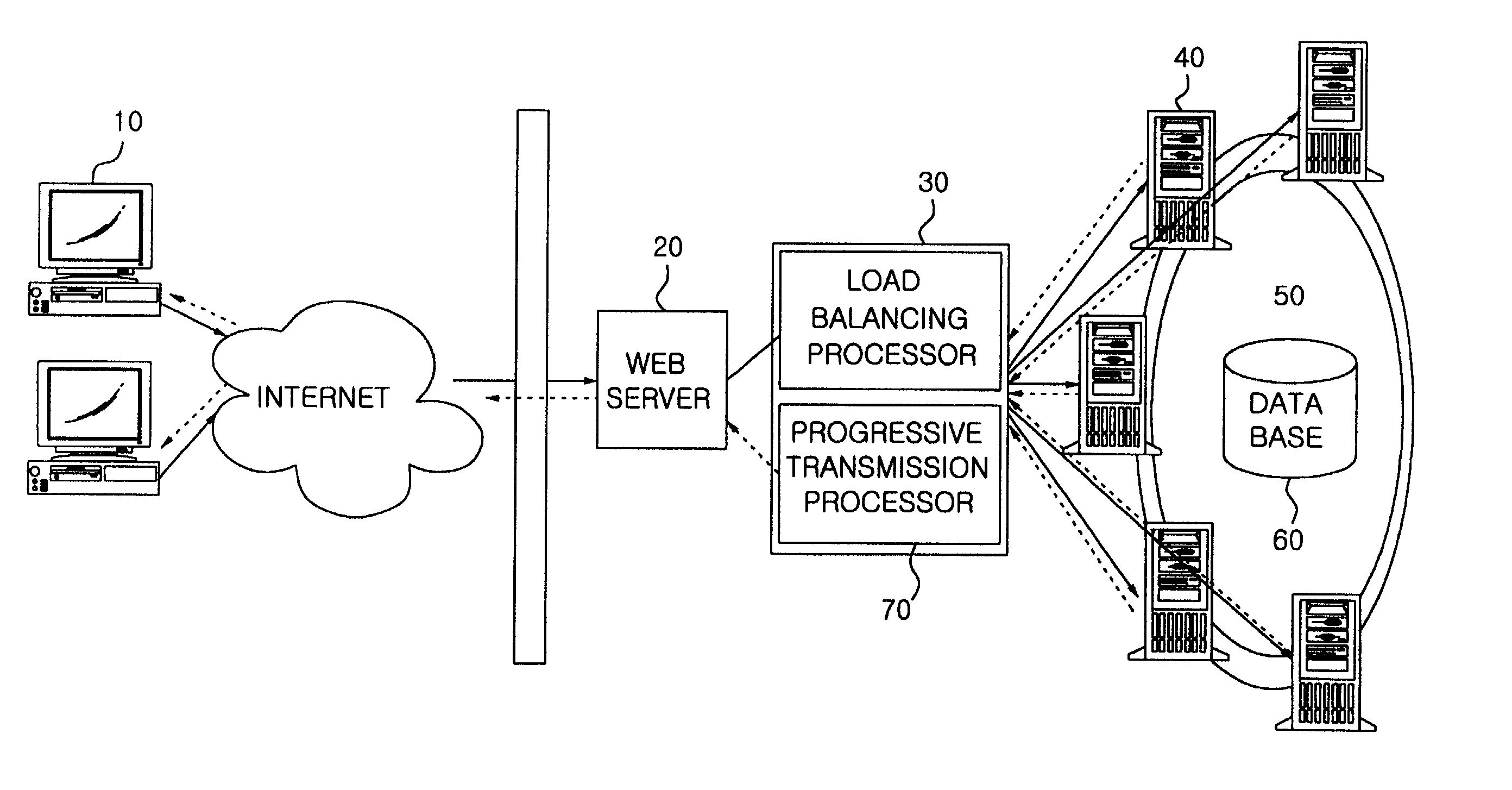
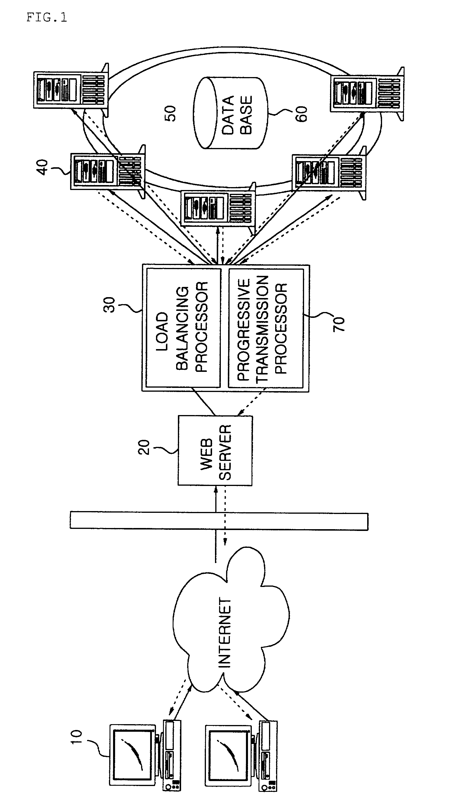
[0032]FIG. 1 illustrates the architecture of a vector-based, clustering Web geographic information system according to the present invention. The system of FIG. 1 comprises at least one client 10, a Web server 20, a load balancing processor 30, a progressive transmission processor 70, a clustering device 50, a plurality of geographic information system (GIS) servers 40, and a spatial / non-spatial database 60.

[0033]The client 10 downloads a Web page from the Web server through a Web browser, receives vector data of a region requested by a user by communicating with a corresponding control server or an applet server using a hypertext transfer protocol (HTTP), and displays the received data on a screen. The Web server 20 transmits all spatial queries received from an object downloaded to the client 10 to the load balancing processor 30.

[0034]The load bala...


PUM


Abstract

A vector-based system maximizes the performance of a server of a clustering Web geographic information system by realizing efficient load balancing using a load balancing processor, thus improving the system's reliability and stability. A control method of the system minimizes a user response time by using a progressive transmission technique when transmitting vector data.

Description

BACKGROUND OF THE INVENTION[0001]1. Field of the Invention[0002]The present invention relates generally to clustering Web geographic information systems, and more particularly, to a vector-based system and a control method thereof, which can maximize the performance of a server using efficient load balancing in a Web geographic information system and which can minimize user response time using a progressive transmission technique when transmitting vector data.[0003]2. Discussion of the Related Art[0004]Web geographic information systems are classified into vector-based systems and image-based (raster-based) systems, and the present invention is notably directed to the former rather than the latter. A vector-based system is achieved using a method whereby a single server processes the queries requested by clients, constructs result data to be transmitted, and compresses and transmits the constructed data. If several servers process the queries, the queries are distributed and process...

Claims


Application Information

Patent Timeline
Patent Type & Authority Patents(United States)
IPC IPC(8): G06F17/30H04L29/08
CPCG06F17/30861H04L67/18H04L69/329Y10S707/99931Y10S707/99933Y10S707/99945G06F16/95H04L67/52
Inventor BAE, HAE-YOUNGOH, YOUNG-WHANLEE, CHUNG-HO
Owner JUNGSEOK INHA SCHOOLS FOUND
Why Eureka
Try Eureka