Encoding geographic coordinates in a fuzzy geographic address

a geographic address and fuzzy technology, applied in the field of encoding geographic coordinates in fuzzy geographic addresses, can solve the problems of increasing problems, unable to be solved, and unable to solve problems, so as to improve the current methods and systems

Inactive Publication Date: 2006-02-28
MEDIATEK INC
View PDF19 Cites 365 Cited by
  • Summary
  • Abstract
  • Description
  • Claims
  • Application Information

AI Technical Summary

Benefits of technology

[0051]It is an object of the present invention to improve the current methods and systems for searching and retrieving geographic or location related information on the Web.
[0054]It is a further object of the present invention to access, retrieve and browse information according to a geographic distribution (instead of an alphabetic order) giving thus to all Web servers with location related information an improved opportunity and an equal chance to share information.
[0055]It is a further object of the present invention to provide Internet users with automatically created and updated maps showing the geographic distribution of any place with any type of resources that could be referenced throughout the Web.
[0056]It is a further object of the present invention to allows Internet users to browse information, select, locate, navigate and reach places in the world without accessing specific geographic information providers or geographic information systems.
[0058]It is another object of the present invention to allow Internet users to map locations selected according to a particular location type, simply by specifying a single reference point of the world (this point being their actual position or any other remote virtual position), and by specifying the size of the geographic area around this reference point.
[0059]It is still another object of the present invention to selectively, interactively and automatically overlay conventional digital maps with an updated distribution of locations of the type the user is searching, thus avoiding an overload of conventional maps with excess of irrelevant or outdated information.SUMMARY OF THE INVENTION

Problems solved by technology

Because more and more information is placed on the Web, users are faced with the growing problem of searching, identifying and selecting a rich, updated and useful information among an enormous amount of information, most of the time irrelevant for the intended purposes.
As more and more information becomes available in ever more intricate forms on the Net, the problem promises only to become worse, particularly as it is so difficult to distinguish good, reliable information from the false or outdated variety.”—Marguerite Holloway—“Labeling the Web”, by Marguerite Holloway, IBM Research Magazine, Vol. 35, No. 3, 1997.
The challenge of WebGIS is to create software systems that are platform independent and able run on open TCP / IP networks (Transmission Control Protocol / Internet Protocol networks), that means on any computer capable of connecting to the Internet (or any TCP / IP network) and running a Web Browser.
It is not possible, directly from the maps, to link and get access to the information associated to the different locations represented on the maps.is specialized and limited to certain types of data selected by the information provider (e.g. Fodor's restaurant index on http: / / www.fodors.com / ri.cgi, Fodor's hotel index on http: / / www.fodors.com / hi.cgi).
The information is simply limited to “what you see”.
Proprietary, static and specialized maps in general provide a limited amount of information and in many instances they lack the information that the user is interested in knowing.
The design, content richness, maintenance, scale or resolution are limited most of the time for cost reasons.
Frequently, proprietary maps are outdated, and they do not contain the required, updated and useful information.
Out of very limited geometric operations (translate, rotate, pan, zoom), most of them lack powerful advanced tools to modify the information (the views) shown or to increase the information content (the view) of the map to reflect the geographic distribution of all possible kinds of selectable types of locations, establishments or service points (e.g.: locations of restaurants, pharmacies, parking, police stations, hospitals, historic monuments, bakeries, pubs, etc.).
The problem is then to identify the location sometimes from a very large list of documents.

Method used


Image

  • Encoding geographic coordinates in a fuzzy geographic address
  • Encoding geographic coordinates in a fuzzy geographic address
  • Encoding geographic coordinates in a fuzzy geographic address

Examples


Embodiment Construction

Introduction

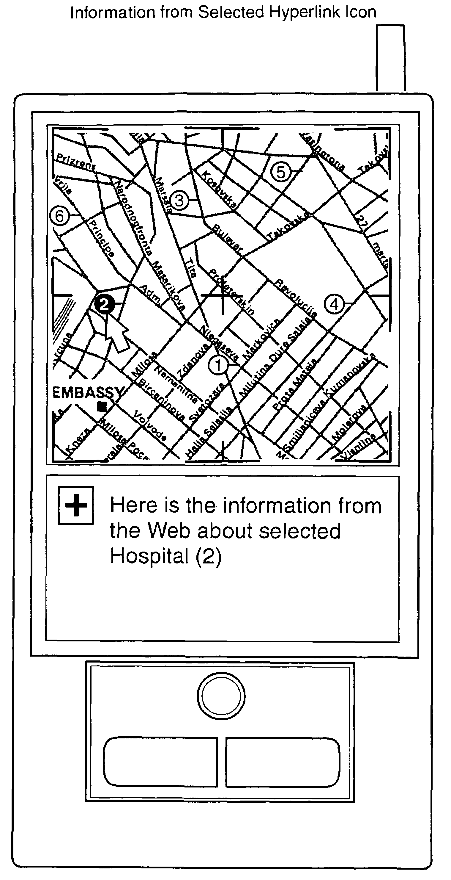
[0089]The present invention relates to a system and method for accessing, retrieving, representing and browsing geographic or location related information from the Web (i.e.: HTML documents that describe physical places). More particularly, the present invention relates to a system and method for automatically searching, retrieving, representing and browsing from the Web a geographic distribution of places where selectable types of resources are located or certain types of services provided (hospitals, bus terminals, historical places, oil-posts, restaurants, hotels, etc. . . .). These places are located inside regions of different sizes around any reference point of the world. The invention enables a user to select any one of the automatically mapped locations and to browse the information retrieved from the World Wide Web for this location, without any resort to services of specialized geographic information systems or geographic information providers.

Document Tagging

[...


PUM


Abstract

A system and method for searching, accessing, retrieving, representing and browsing geographic or location related information from the Web (i.e.: HTML documents that describe physical places), including a geographic distribution of places where selectable types of resources are located or certain types of services provided. A user may select any one of the automatically mapped locations and browse the information for this location.Documents accessible through the Web are tagged with the cartographic coordinates of the physical location referenced in the document and, optionally, with attributes of this physical location. Also provided is a method for searching and retrieving the tagged documents from a computer system by queries specifying parameters such as the cartographic coordinates of a reference location, the size of the geographic area to search around this reference location, and / or attributes of the locations to search inside that geographic area.

Description

FIELD OF THE INVENTION[0001]The present invention relates to Internet and network computing technologies and more particularly to a system and method for automatically searching, retrieving and mapping from the World Wide Web (www) a geographic distribution of places where specific types of resources are located or certain types of services provided (hospitals, bus terminals, historical places, oil-posts, restaurants, hotels, etc.).BACKGROUND ARTInternet[0002]Internet is a global network of computers and computers networks (the “Net”). The Internet connects computers that use a variety of different operating systems or languages, including UNIX, DOS, Windows, Macintosh, and others. To facilitate and allow the communication among these various systems and languages, the Internet uses a language referred to as TCP / IP (“Transmission Control Protocol / Internet Protocol”). TCP / IP protocol supports three basic applications on the Internet:[0003]transmitting and receiving electronic mail (e...

Claims


Application Information

Patent Timeline
Patent Type & Authority Patents(United States)
IPC IPC(8): G06F7/00G01C21/26G06F17/30
CPCG01C21/26G06F17/3087Y10S707/99933G06F16/9537
Inventor CARRO, FERNANDO INCERTIS
Owner MEDIATEK INC
Why Eureka
Try Eureka