System and method for CSEM exploration in polar regions

a polar region and csem technology, applied in seismology for waterlogging, instruments, electromagnetic wave detection, etc., can solve the problems of weak and variable data, affecting the land application of csem in the hydrocarbon context, and general decay of data measured voltage, so as to improve ground coupling and improve the effect of exploration, appraisal, development and surveillan

Inactive Publication Date: 2008-05-20
BP CORP NORTH AMERICA INC
View PDF15 Cites 8 Cited by
  • Summary
  • Abstract
  • Description
  • Claims
  • Application Information

AI Technical Summary

Benefits of technology

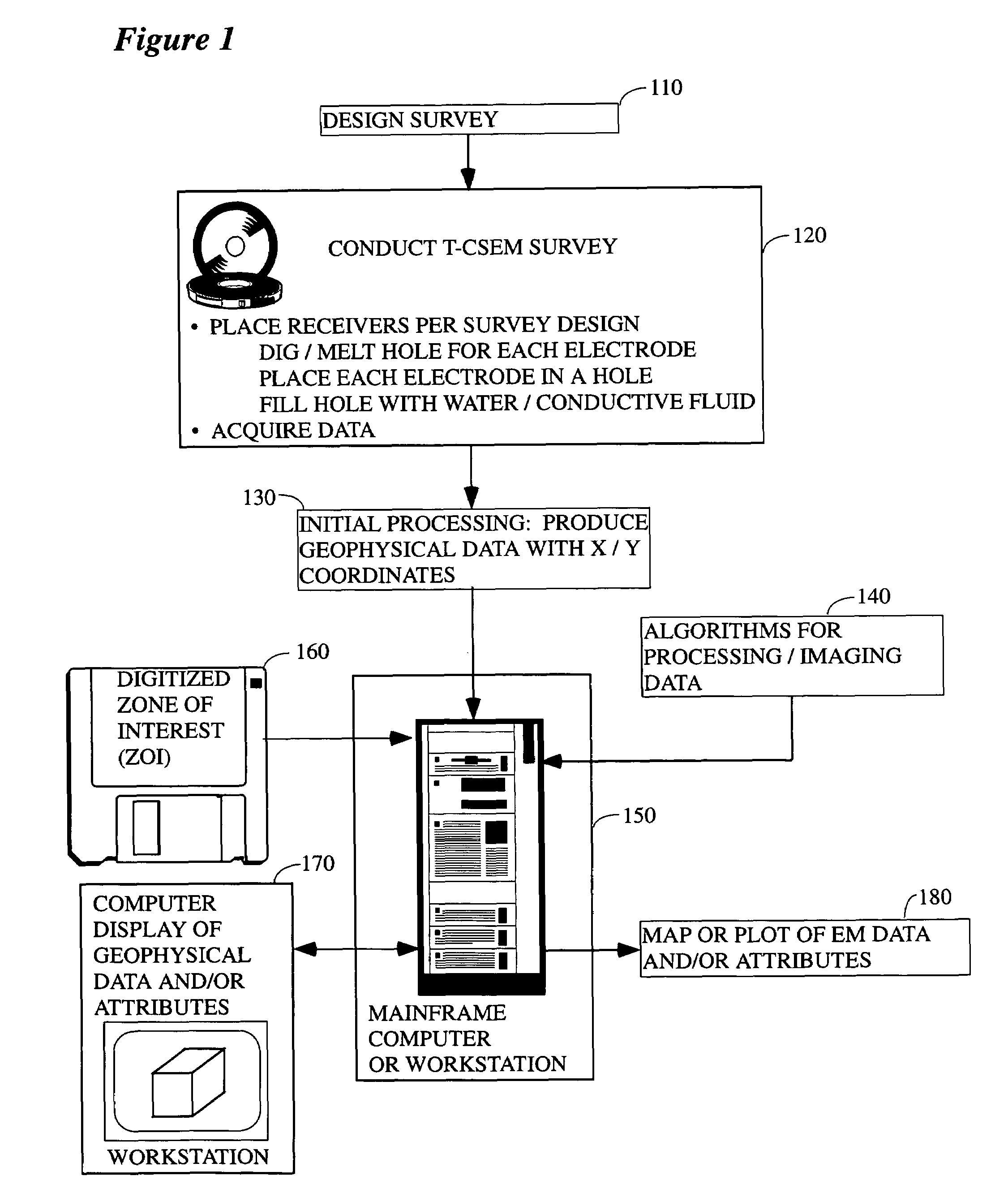
[0018]According to a preferred aspect of the instant invention, there is provided a system and method of collecting CSEM data (and especially t-CSEM data), which permits effective exploration, appraisal, development, and surveillance of hydrocarbon reservoirs in polar regions by providing improved ground coupling between the electrodes, the surficial ice, the sub-ice water, and hence, to the earth itself. As a consequence, a higher quality transmitted and received signal is obtained, and through the use of the methods taught herein, CSEM becomes feasible for use in hydrocarbon detection in such regions.
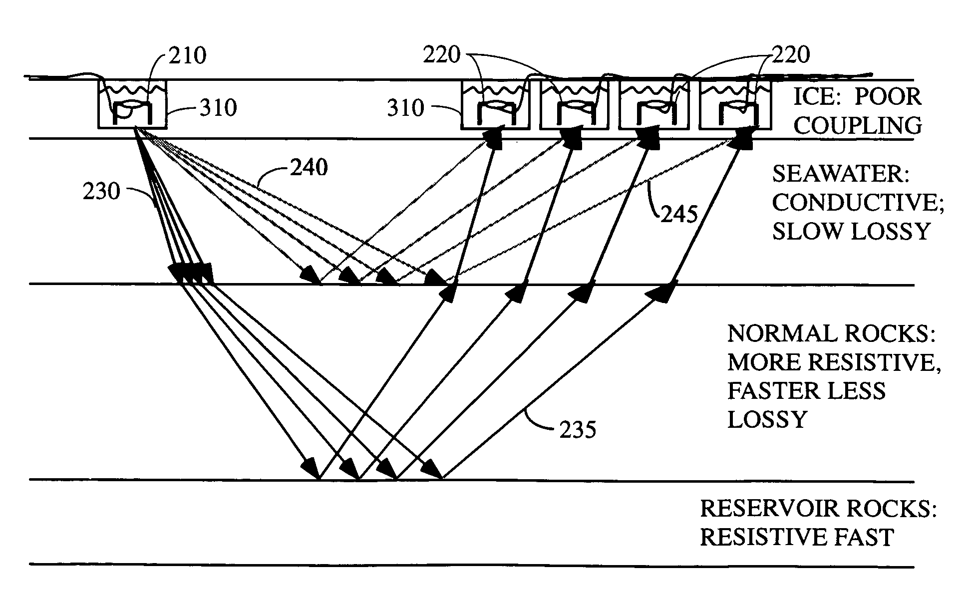
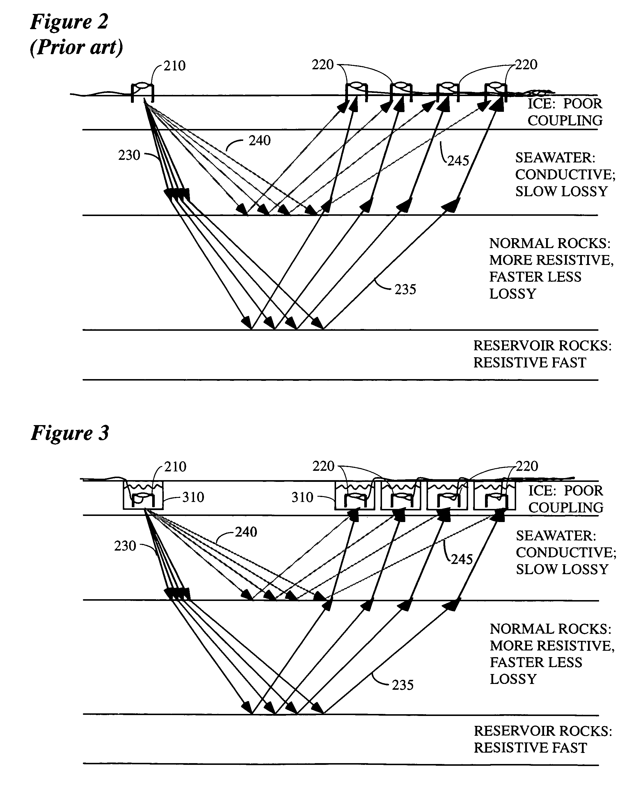
[0022]Note that this approach makes it possible for the first time to collect high quality EM data in a marine setting by using modified land techniques. That is, one aspect of the instant invention involves conducting a CSEM survey on the pack ice floating on water (fresh- or salt-water). Obviously, if the weather were warmer, and the ice were melted, a conventional or unconventional marine survey could be conducted (e.g., as is generally indicated in FIG. 5). However, in polar regions the season of open water is short or absent, so that these marine techniques have limited applicability. However, when the body of water (or at least a portion of it) freezes over, a land-style survey may be conducted instead on the resulting ice layer. In the case of marine surface ice, the electrode holes may easily penetrate the floating ice, reaching the unfrozen seawater below (which has excellent conductivity), and avoiding altogether those problems caused by the poor conductivity of ice. In this marine case, the data are analyzed by means described elsewhere, perhaps taking special steps to account for reflection from the seafloor.
[0023]In another variation, there is provided a method of EM exploration in polar regions that may be covered by tundra, or by swamps, or by wide shallow rivers which are ecologically fragile, particularly during warmer seasons. Those of ordinary skill in the art will recognize that the only practical time to enter such areas with men and equipment is during the colder seasons, when the surface is stabilized by ice and snow-cover. During that season seismic exploration is feasible, but logistically difficult, because the cold weather causes mechanical devices (e.g. vibrators) to fail more often than in warmer weather. Further, obtaining high quality coupling of seismic geophones to the ground during this time is problematic. Also, seismic sampling requirements are more stringent than are EM sampling requirements (since the seismic wavelengths are shorter than the EM wavelengths, in typical practice), so that many more source-locations and receiver-locations are required for seismic surveying than for CSEM surveying. According to the instant invention there is provided a CSEM surveying method substantially as described above, but wherein the ground coupling is improved by digging or drilling holes into the tundra or ice into which the electrodes are thereafter placed. Note that through the use of the present invention, CSEM in such environments can serve to identify areas that are likely to contain hydrocarbons in the subsurface, making it possible to high-grade those particular areas for subsequent seismic surveys that are more suitable for obtaining high-resolution seismic images of those reservoirs.
[0024]In another variation, in a survey conducted on ice or snow, magnetic energy is injected into the ice, via current loops deployed over the ice, and received (via surface and subsurface propagation paths) at current loops similarly deployed, at a range of distances from the sources. This sort of survey is particularly useful at finding conductive anomalies, rather than resistive anomalies (hydrocarbons). Nevertheless, the present invention can be utilized to conduct such a conventional land-based magnetic survey on top of floating ice during cold weather. Compared to conventional marine CSEM surveying (with sources and receivers near the sea-floor), a marine survey conducted as described above requires that the EM energy signal from the subsurface propagates additionally through the water layer, twice (down and up). This means that the current invention will be more useful in shallow waters than in deep waters, although with sufficiently powerful sources and sufficiently sensitive receivers, the depths can be extended. Modeling shows that sea-water of 100 m depth causes no serious problems.
[0025]In summary, the present inventors have discovered that a critical feature of the marine environment, which makes conventional CSEM practical in that setting, is the intimate and uniform coupling of sources and receivers to the medium (seawater). Those skilled in the art of marine CSEM will realize that deep water (relative to target depth) is also important to the practicality of f-CSEM, but that this restriction does not apply to t-CSEM. As is disclosed herein, the present inventors have realized that this coupling-principle can also be realized in polar environments, because of the ubiquity in such environments of ice and snow. This is a key aspect of the present invention, i.e., the realization that according to the techniques taught herein ice provides for good coupling in polar environments in the same fashion as water provides same in marine environments, thereby making it possible to collect high quality CSEM data. In particular, the techniques taught herein enable the collection of high-quality, CSEM data, suitable for exploration for the deep resistivity anomalies characteristic of hydrocarbon reservoirs.

Problems solved by technology

Of course, such data display a general decay in the measured voltages as time progresses subsequent to the source shut-off.
However, land application of CSEM in the hydrocarbon context has been hampered heretofore by difficulties in survey execution, caused by variable coupling of the sources and receivers to the ground.
However, the properties of the ground in the vicinity of the electrodes (e.g., variable soil conditions, water saturation, etc.), especially the source electrodes, affects the coupling to the deeper subsurface, so that, if the coupling is not good, the resulting data is weak and variable, and the subsurface signal is compromised.
In particular, the strong and variable mismatch in electrical impedance (between the instruments, the near-by ground, and the deep subsurface) contributes strongly to these acquisition difficulties.
Because of this ground-coupling problem, the success of land CSEM techniques has been variable, and they have not historically been proven to be broadly useful for hydrocarbon exploration.
However, recently attempts to provide commercial services have been launched; these services have been restricted to the conventional oil basins of temperate and tropical latitudes.
Exploration for hydrocarbons in the Polar regions of the earth is hindered by a myriad of practical difficulties associated with the cold temperatures: men and equipment simply do not function well in such environments.
In particular, offshore the floating pack ice makes conventional seismic exploration infeasible, and onshore the surface conditions severely discourage the application of proven methods of exploration.
Under these conditions, practitioners have not even attempted to apply CSEM exploration methods, which have proven to be unreliable in less harsh conditions, to these more difficult polar environments.

Method used


Image

  • System and method for CSEM exploration in polar regions
  • System and method for CSEM exploration in polar regions
  • System and method for CSEM exploration in polar regions

Examples


Embodiment Construction

[0035]While this invention is susceptible of being embodied in many different forms, there is shown in the drawings, and will herein be described, some specific embodiments of the instant invention. It should be understood, however, that the present disclosure is to be considered an exemplification of the principles of the invention and is not intended to limit the invention to the specific embodiments or algorithms so described. In particular, although the exemplification is generally given in terms of t-CSEM, those skilled in the art will recognize that, with good coupling of electrodes to the ground, f-CSEM techniques might also be used.

GENERAL ENVIRONMENT OF THE INVENTION

[0036]FIG. 1 illustrates the general environment in which the instant invention would typically be used. As a first step, an EM survey will be designed (step 110), wherein such design would typically include specification of various survey parameters that are designed to define the target and improve the quality...


PUM


Abstract

There is provided herein a system and method of collecting, EM data in the context(s) of hydrocarbon exploration, appraisal, development, and surveillance, which provides improved ground coupling between the electrodes and the earth or surface ice and, as a consequence, a higher quality transmitted and received signal is obtained thereby. Where the surface of the ground is saturated and frozen (e.g., in the case of a survey conducted on sea ice or frozen tundra), the survey instruments (sources and receivers) may be coupled more faithfully to the surface by drilling or melting holes into the ice (or frozen tundra) and inserting electrodes into the resulting holes. Each hole may (or may not) be lined with material to retard the loss of water therefrom. Preferably, each of the holes (source and receiver) will be filled with water (fresh or salt) before data collection begins.

Description

TECHNICAL FIELD[0001]This invention relates to the general subject of geophysical exploration for hydrocarbons and, in particular, to methods for collecting and analyzing controlled source electromagnetic (“CSEM”, hereinafter) earth survey data, with particular reference to polar regions of the earth.BACKGROUND OF THE INVENTION[0002]Measurements of subsurface electrical resistivity have long been used to differentiate rock layers that contain hydrocarbons from other rock units that do not contain hydrocarbons. For example, resistivity well logs have been routinely used for many years to identify producing intervals within existing well bores. However, more recently, it has been found feasible to use surface surveys, which do not require that a well be drilled, in order to detect subsurface hydrocarbon deposits. That is, information collected on the surface is used to determine the subsurface resistivity distribution in the subsurface—in a non-invasive fashion—beneath a line of recei...

Claims


Application Information

Patent Timeline
Patent Type & Authority Patents(United States)
IPC IPC(8): G01V3/12
CPCG01V3/083G01V3/12Y02A90/30
Inventor SMITH, MICHAEL JOSEPHRITCHIE, BRYAN DAVIDTHOMSEN, LEON
Owner BP CORP NORTH AMERICA INC
Why Eureka
Try Eureka