Learning transportation modes from raw GPS data

Active Publication Date: 2011-09-06
MICROSOFT TECH LICENSING LLC
View PDF23 Cites 289 Cited by
  • Summary
  • Abstract
  • Description
  • Claims
  • Application Information

AI Technical Summary

Benefits of technology

[0008]In one aspect, such as to produce more accurate results, when first characterizing points as corresponding to walk segments or non-walk segments, segments below a threshold merging length are merged into an

Problems solved by technology

However, there is generally no motivation for users to do so to benefit some unknown application, and further, it is difficult for people to remember the accurate time during a given trip when such additional information is appropriate to include.
Additional data collected by other sensors such as cellular phone devices and towers, Wi-Fi, RFID, and/or other information extracted from geographic maps, such as road networks, may help in interpreting GPS data, but this has its own drawbacks.
Some of the drawbacks include a need to have a sufficient number of sensors available and positioned at me

Method used


Image

  • Learning transportation modes from raw GPS data
  • Learning transportation modes from raw GPS data
  • Learning transportation modes from raw GPS data

Examples


Embodiment Construction

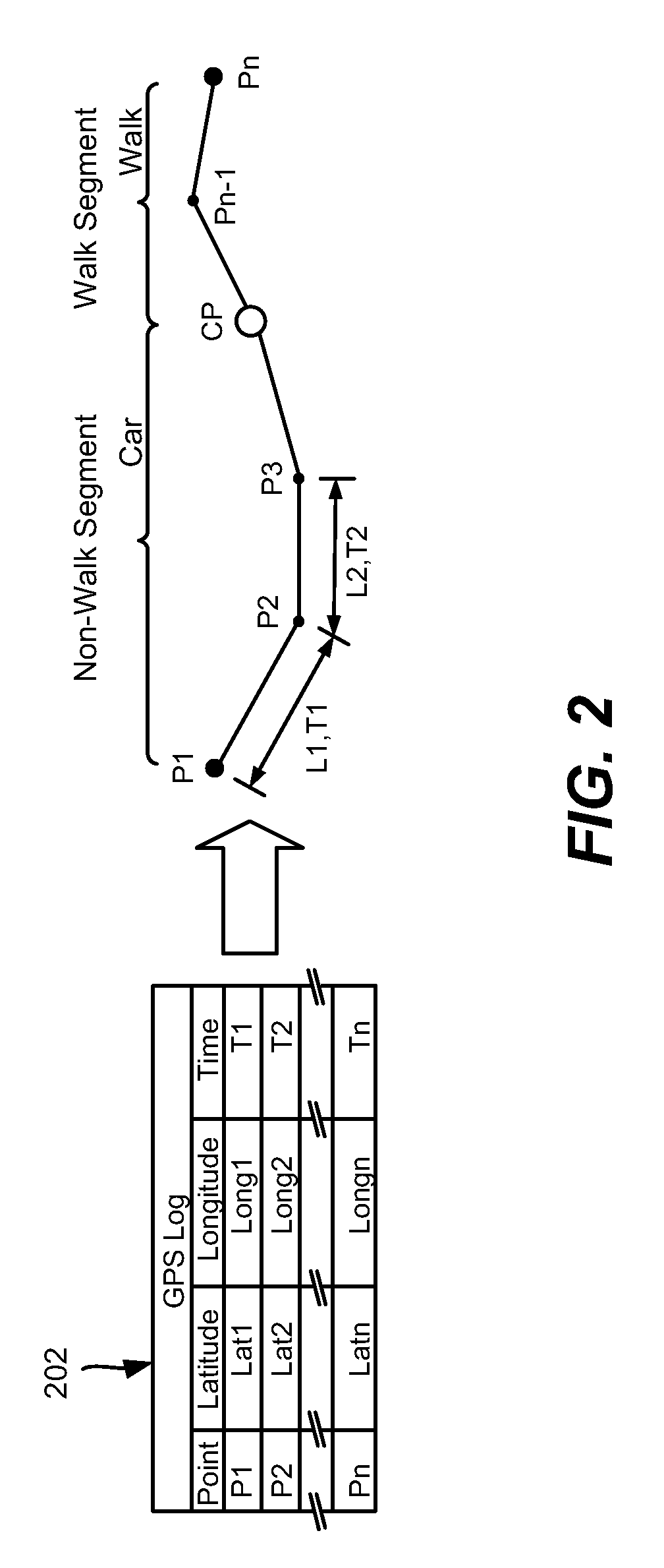
>[0016]FIG. 5 is a representation of a set of segments and data points exemplifying the detection of change points.

[0017]FIGS. 6A and 6B comprise a flow diagram showing example steps taken to process GPS data to determine transportation modes.

[0018]FIG. 7 shows an illustrative example of a computing environment into which various aspects of the present invention may be incorporated.

DETAILED DESCRIPTION

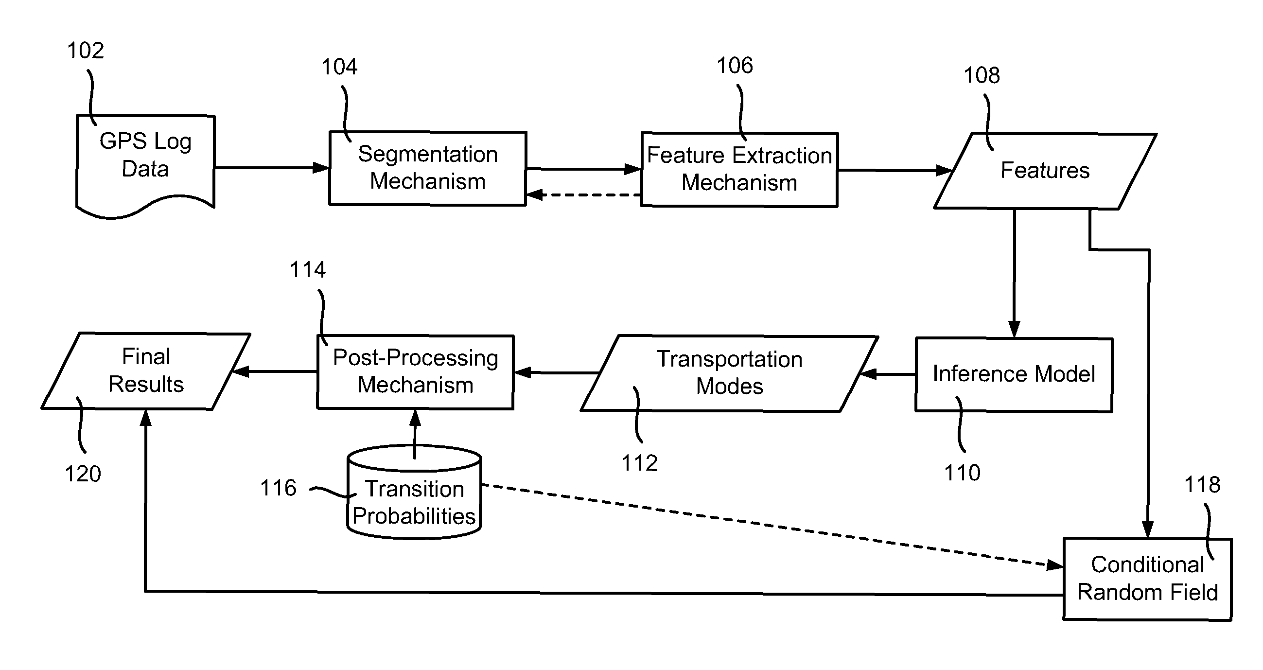
[0019]Various aspects of the technology described herein are generally directed towards automatically determining transportation modes from raw GPS data, including multiple transportation modes in a single trip, and detecting transitions between modes. In one example implementation, this is accomplished via a change point-based segmentation method, an inference model, and a post-processing algorithm that is based on conditional probability. In an alternative implementation, conditional random field inference provides the inference model without the need for post-processing.

[0020]In one...


PUM


Abstract

Described is a technology by which raw GPS data is processed into segments of a trip, with a predicted mode of transportation (e.g., walking, car, bus, bicycling) determined for each segment. The determined transportation modes may be used to tag the GPS data with transportation mode information, and/or dynamically used. Segments are first characterized as walk segments or non-walk segments based on velocity and/or acceleration. Features corresponding to each of those walk segments or non-walk segments are extracted, and analyzed with an inference model to determine probabilities for the possible modes of transportation for each segment. Post-processing may be used to modify the probabilities based on transitioning considerations with respect to the transportation mode of an adjacent segment. The most probable transportation mode for each segment is selected.

Description

RELATED APPLICATIONS[0001]This patent application is related to U.S. patent application Ser. No. 12 / 037,347 to Zheng et al., entitled, “System for Logging Life Experiences Using Geographic Cues,” filed concurrently herewith and incorporated herein by reference; and to U.S. patent application Ser. No. 12 / 037,263 to Wang et al., entitled, “Indexing Large-Scale GPS Tracks,” filed concurrently herewith, and incorporated herein by reference.BACKGROUND[0002]Many users of global positioning system (GPS) devices upload their GPS data (tracks) to the Internet, sometimes in conjunction with photographs and the like, such as for sharing travel and other experiences. In addition to sharing with others, users that upload their GPS tracks may benefit by having a better record of past events, which helps in reliving past events and gaining an understanding of their life patterns. At the same time, applications can attempt to learn from such GPS data, such as to determine popular routes to recommen...

Claims


Application Information

Patent Timeline
IPC IPC(8): G06F9/44G06N7/02G06N7/06
CPCG01C21/20G06N99/005G01C21/3423G08G1/0112G06N20/00
Inventor ZHENG, YUWANG, LONGHAOLIU, LIKEXIE, XING
Owner MICROSOFT TECH LICENSING LLC
Why Eureka
Try Eureka