
Autonomous orbit propagation system and method

a propagation system and autonomous technology, applied in the field of autonomous orbit propagation system and method, can solve the problems of gps signals being too weak to faithfully demodulate, inaccurate demodulation, spotty or difficult demodulation, etc., and achieve the effect of effective higher accuracy and better exploited

Active Publication Date: 2012-02-28
RX NETWORKS INC
View PDF47 Cites 13 Cited by
  • Summary
  • Abstract
  • Description
  • Claims
  • Application Information

AI Technical Summary

Benefits of technology

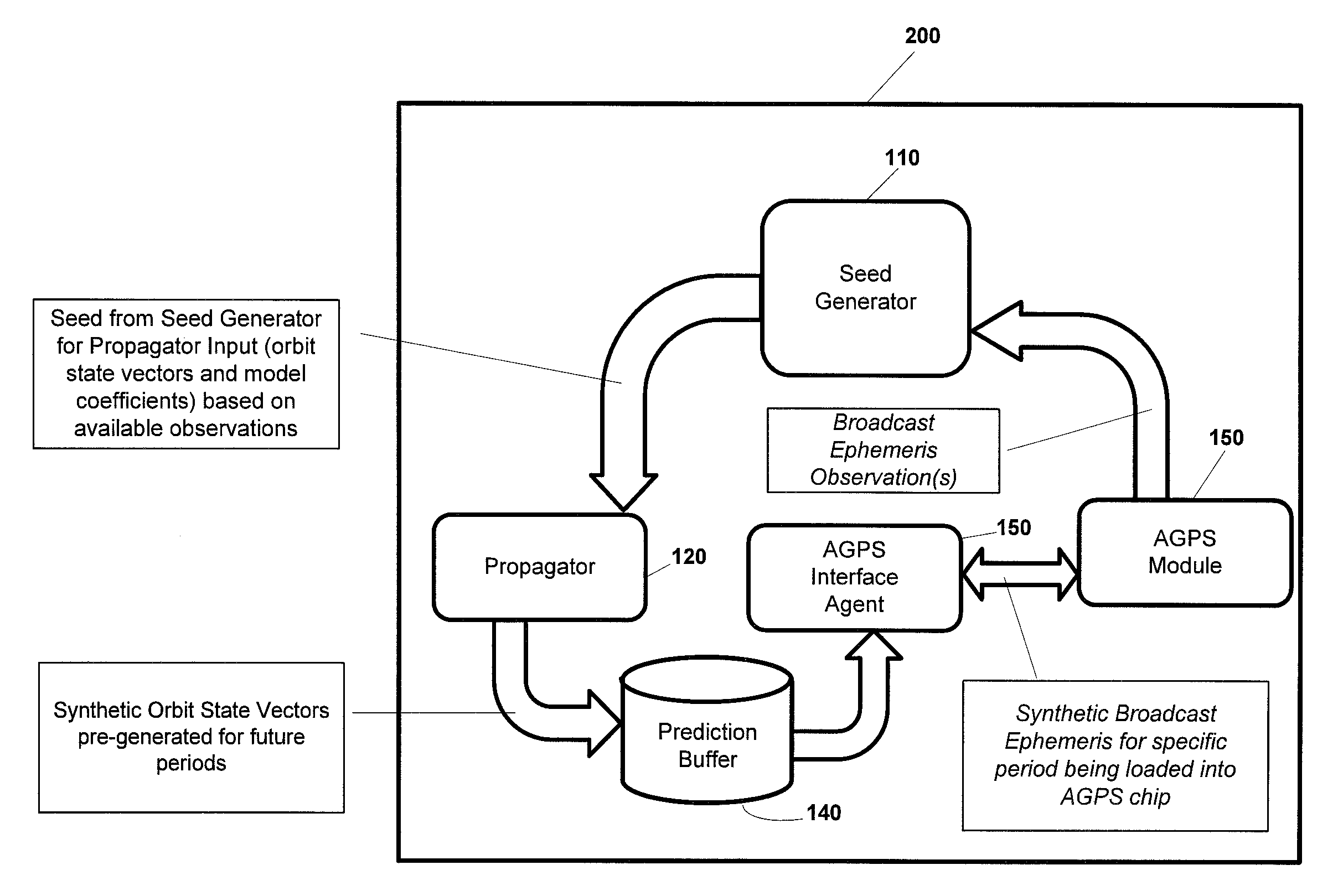
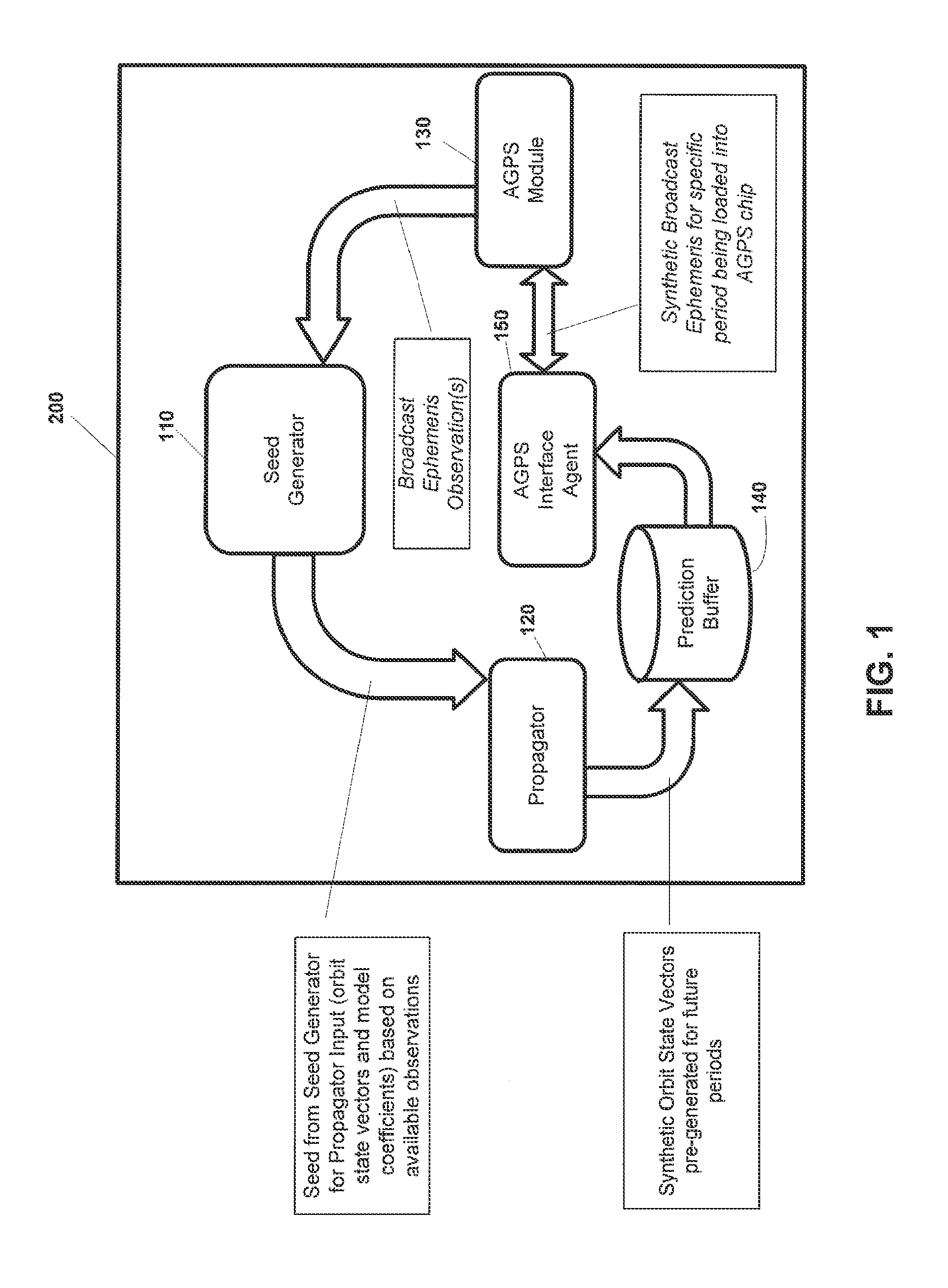
The invention proposes a new method for generating assistance data for GPS devices that allows them to operate autonomously without needing a connection to an AGPS server. The method uses a combination of force models and observations of real broadcast ephemeris to predict the position and velocity of GPS satellites. This method provides higher accuracy and reliability than previous methods and allows GPS devices to start up quickly and use their sensitivity. It also allows for the prediction of future GPS satellite orbits based on the current GPS device's position and velocity. The invention provides software and hardware modules for GPS devices to implement this method, and an AGPS interface agent for providing assistance data to GPS devices. The method can be used even when there is no external connection available.

Problems solved by technology

Although the model allows for the evaluation of the satellite position beyond the 4 to 6 hours of validity, the accuracy typically degrades to the level of about a kilometer within a day.
Jamming and / or attenuated RF environments, such as urban environments or indoor locations, make demodulation spotty or difficult.
In some cases GPS signals are too weak to faithfully demodulate navigation data, yet they are strong enough to be tracked using the current generation of receivers.
An important limitation of the AGPS techniques discussed above is that they require some form of connection, network or direct, to a server, to download Assistance data to the GPS device.
Some GPS devices lack external connection capability, network or otherwise, and in some cases, a connection-capable device may be unable to establish a connection for a long period of time to a server.
Under these conditions, GPS devices cannot use the AGPS techniques mentioned above and performance is impacted.
Additionally, devices using Real-Time Assistance techniques consume network resources when downloading the Assistance.
However, operating within the Keplerian model severely limits the ability of a GPS device to reliably predict these values beyond a day or so.
The prior art techniques do not provide a GPS device the ability to propagate orbital information with the required accuracy for position computation.
The prior art does not enable a GPS device to use Broadcast Ephemeris as direct input to synthesize its own assistance data.

Method used


Image

  • Autonomous orbit propagation system and method
  • Autonomous orbit propagation system and method
  • Autonomous orbit propagation system and method

Examples


Embodiment Construction

[0046]In this document, the following terms have the following meanings:[0047]“AGPS Interface Agent” means a software or hardware module for converting a Prediction Buffer to a synthetic ephemeris in a format acceptable to an AGPS Module;[0048]“AGPS Module” means a software or hardware module, such as a chipset, for managing input to a GPS device, such as real or synthetic ephemeris, or time frequency and an estimated satellite position;[0049]“AGPS Server” means a server generating Assistance for use by a Seed Generator or Propagator on a GPS device in communication with the AGPS Server;[0050]“GPS device” means an object having a GPS receiver and associated digital processor for receiving and processing signals from GPS satellites. A GPS device may be handheld, or may be part of a larger structure, such as a vehicle;[0051]“Orbit State Vector” means a vector containing information about the position, and velocity of a satellite at a given epoch;[0052]“Propagator” means a hardware or ...


PUM


Abstract

A method of predicting a location of a satellite is provided wherein the GPS device, based on previously received information about the position of a satellite, such as an ephemeris, generates a correction acceleration of the satellite that can be used to predict the position of the satellite outside of the time frame in which the previously received information was valid. The calculations can be performed entirely on the GPS device, and do not require assistance from a server. However, if assistance from a server is available to the GPS device, the assistance information can be used to increase the accuracy of the predicted position.

Description

RELATED APPLICATIONS[0001]This application is a continuation in part of U.S. patent application Ser. No. 11 / 740,206 filed Apr. 25, 2007 and a continuation of PCT patent application entitled AUTONOMOUS ORBIT PROPAGATION SYSTEM AND METHOD filed on Nov. 7, 2008, which claims priority from U.S. provisional application No. 60 / 986,972 filed Nov. 9, 2007.FIELD OF THE INVENTION[0002]This invention relates to methods and apparatus for predicting and using navigation satellite orbit position data, such as that provided by Global Positioning System (GPS) satellites, as well as other Global Navigation Satellite Systems (GNSS) and other satellite systems or combinations thereof.BACKGROUND OF THE INVENTION[0003]Satellite positioning and the prediction of satellite positions are used extensively for many applications, for example vehicle navigation systems and portable GPS devices. For example, in order to compute a position, GPS receivers on GPS devices require the positions of the GPS satellites...

Claims


Application Information

Patent Timeline
Patent Type & Authority Patents(United States)
IPC IPC(8): G01S19/27G01S19/05G01S19/25
CPCG01S19/05G01S19/27G01S19/258
Inventor DERBEZ, ERICROY-MACHABEE, GUYLIANCAYER, DAVE
Owner RX NETWORKS INC
Learn More