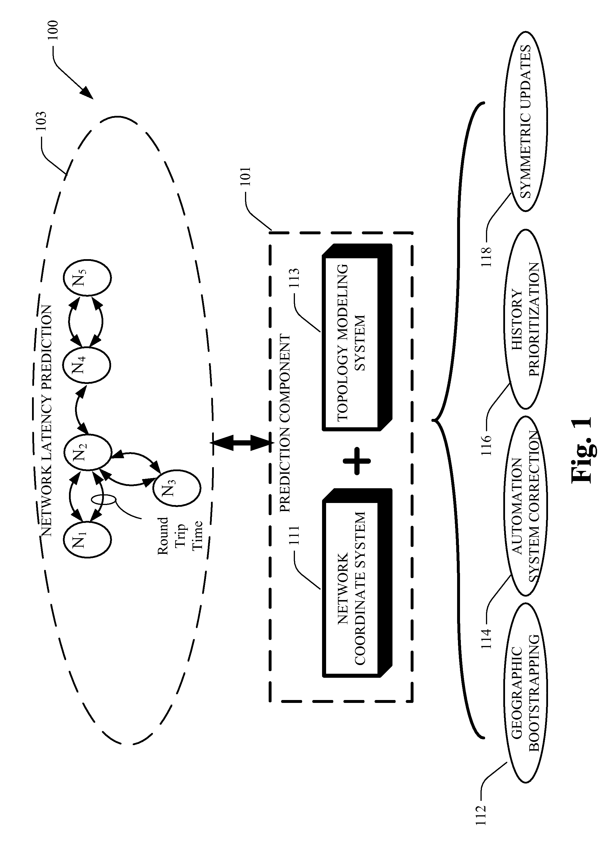
[0007]The subject innovation improves prediction of network latency in network coordinate systems (NCS). It augments an NCS by employing geographic
bootstrapping, autonomous system correction (AS), history prioritization, symmetric updates, or a combination thereof. NCSes use observations of latency measurements among a substantially large number of nodes to build
virtual coordinates for mimicking the latency therebetween. Moreover, such
virtual coordinates can be employed to determine what the latency between other nodes is likely to be. The subject innovation maintains existing advantages associated with the NCS, such as being amenable to de-centralized implementation systems, being responsive to changing Internet conditions, and being inclusive of measurements from all participating nodes.
[0008]In one aspect, geographic
bootstrapping can represent initializing a node's virtual coordinate based on its approximate physical location (e.g., a geographical location on Earth, using techniques where distances between nodes can be used to approximate round trip time,) instead of at an arbitrary default origin point. Such an approach merges the benefits of NCS and geographic prediction and can produce a better result. Unlike a traditional NCS that begins with random initial conditions, the subject innovation initializes coordinates in approximately correct relative positions and so converges to a state with greater
predictive power and higher confidence. Likewise, and unlike geographic prediction that produces static results, the subject innovation permits virtual node locations to vary dynamically based on round-trip time (RTT) observations. As such, the subject innovation can recover from errors in geographic location, adapt to changing
network conditions, and
handle nodes that diverge from typical models relating distance to latency.
[0009]In a related aspect, NCSes typically give each node an extra-dimensional coordinate referred to as its height. As such, it can model the component of latency due to having to
traverse a path to a network core within the AS before proceeding toward any particular destination outside the AS. In the autonomous system (AS)
correction technique, each node determines what AS it belongs to, and then can employ a formula to substantially increase the accuracy of its RTT predictions. Put differently, a network coordinate system typically assigns to each node an extra coordinate referred to as a height, which represents the overhead of reaching this node from the core of
the Internet. The subject innovation can detect when both end points are in the same AS, and incorporate a predetermined formula to substantially increase accuracy of latency predictions.
[0010]Likewise, a further aspect of the subject innovation employs history prioritization to improve prediction of network latency in network coordinate systems (NCS). As such, using the network latency learned from prior probes between the same pair of nodes can produce superior results as compared to predictions based on coordinate distances between that pair of nodes.
[0011]A further aspect of the subject innovation is symmetric updates, which work as follows. When a node samples the RTT to another node, a typical NCS updates only the probing node's coordinates. The subject innovation updates coordinates of both nodes to substantially improve the predictive accuracy of the system. Such approach is readily applicable in systems that can afford a modest increase in network traffic and that have mutually trusting nodes. Put differently, in a network coordinate system, when a node probes another node, that other node can further update its own coordinates. Updating coordinates of both nodes substantially improves prediction accuracy.
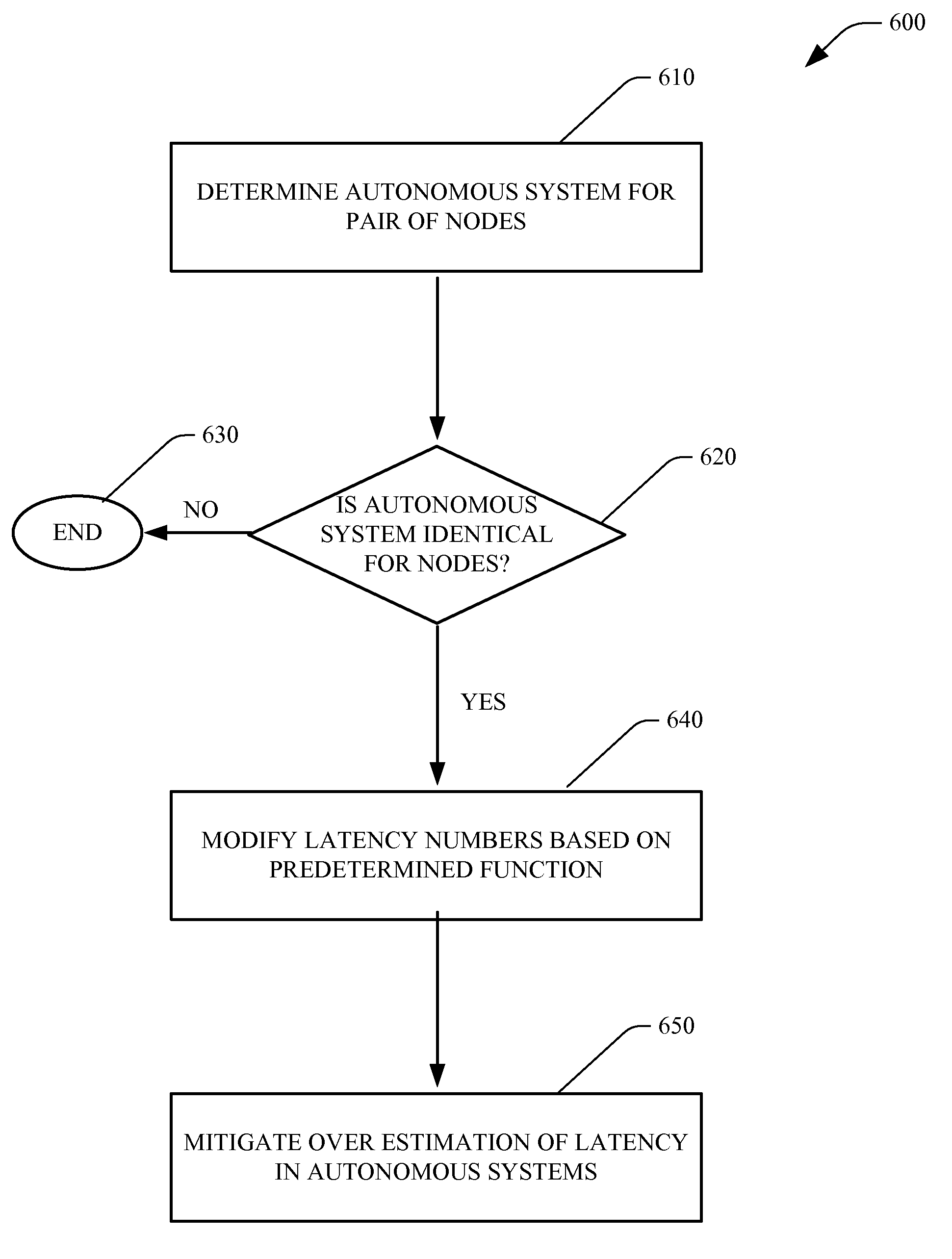
[0013]Likewise, for autonomous systems, initially for a node a determination is made regarding which autonomous system (AS) such node is located therein, (e.g., by determining who owns the node in a public registry). In one aspect, once two nodes have decided which AS they belong to, a subsequent determination is made as to whether such AS numbers are the same. If such numbers are not identical the methodology ends, and no further action is taken as the process is not applied thereto. Alternatively, if the numbers are identical the latency numbers can be modified between the two latency nodes, wherein a function of two heights (e.g., 20% of the total) can be subtracted from the latency estimate. Such an approach can mitigate inaccuracies resulting from overestimation of latencies within autonomous systems in the underlying coordinate system.

