Method and system for refining accuracy of location positioning

a technology of location positioning and refining accuracy, which is applied in the field of method and system for refining accuracy of location positioning, can solve the problems of poor performance of location tracking system, easy interruption of satellite signal reception, time-consuming task, etc., and achieve the effect of improving location determination accuracy and reducing the time of location determination

Active Publication Date: 2012-10-23
GLOPOS FZC
View PDF9 Cites 59 Cited by
  • Summary
  • Abstract
  • Description
  • Claims
  • Application Information

AI Technical Summary

Benefits of technology

[0006]It is an objective of the invention to provide a method, system and module for determining the location of the mobile device that is configured to collect and transmit further at least positioning data and at least some wireless communication cell data. The method, system and module allow improved accuracy in location determination as well as reduced time in location determination.

Problems solved by technology

However, the reception of signals from the satellites easily suffers from interruptions caused by landscape obstructions such as geographic features, buildings, trees, etc.
Because location tracking devices are often operated in environments, such as cities and urban areas, wherein GPS signal reception will be intermittent, this can result in poor performance of the location tracking system.
In the prior art systems the initial, actual and final location determination always requires reception of the satellite-based positioning data in each phase which is a time consuming task.
This easily results in inaccurate location estimation because certain environment obstructions and their influences are ignored.

Method used


Image

  • Method and system for refining accuracy of location positioning
  • Method and system for refining accuracy of location positioning
  • Method and system for refining accuracy of location positioning

Examples


Embodiment Construction

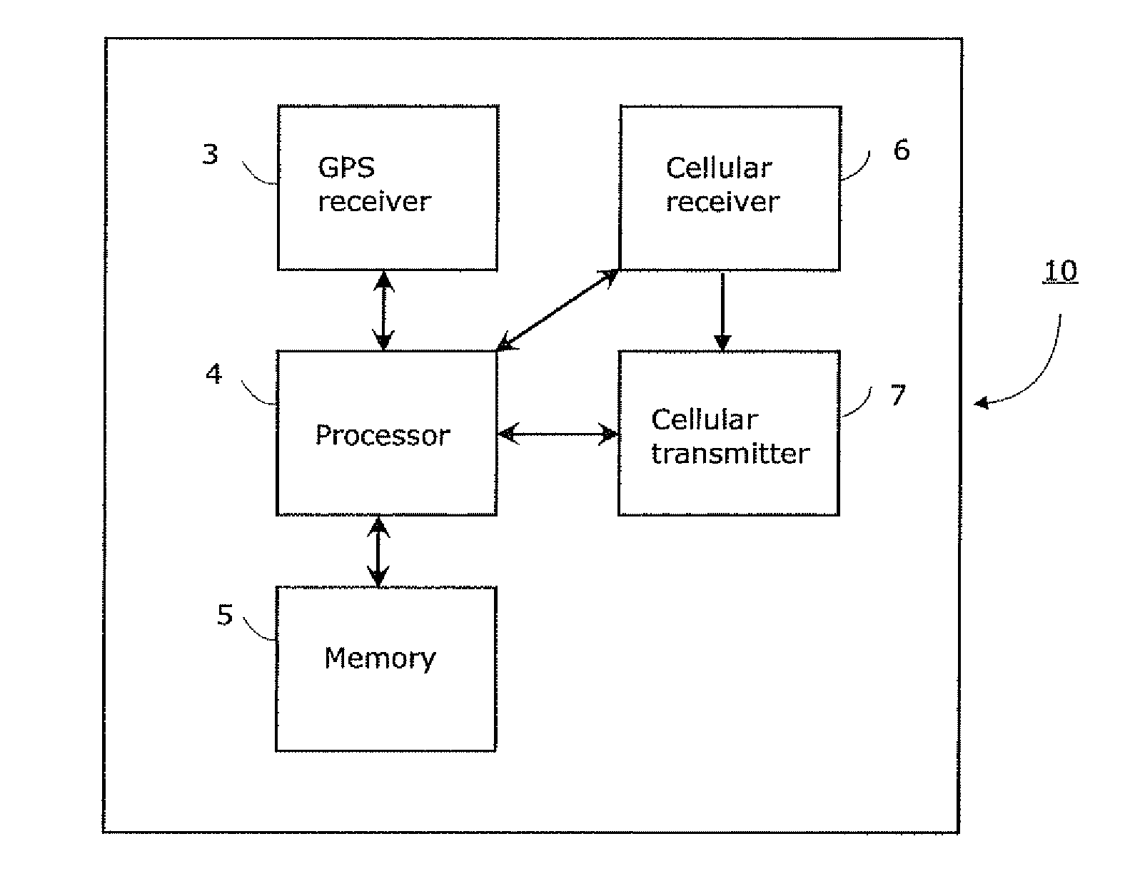
[0068]FIG. 1a shows a block diagram of a mobile device 10 according to an embodiment of the invention. The mobile device 10 may be e.g. a location tracking device or any other such device capable of indicating its present location upon request and / or continuously. The location of the mobile device 10 is monitored when it is moving or in stationary state. The mobile device 10 comprises first receiving means 3 for receiving positioning signals, e.g. satellite-based global positioning system (GPS) signals, and second receiving means 6 for receiving cellular communication network signals, e.g. GSM, GPRS, 3G, CDMA signals. Exemplary as shown in FIG. 1a, the first receiving means may comprise at least one GPS receiver 3 and associated antenna (not shown), and at least one cellular receiver 6 with associated antenna (not shown). The cellular receiver 6 may comprise one or more receiving means for different cellular communication networks and it is capable of receiving signals from cellular...


PUM


Abstract

A method and system for accurately determining the location of the mobile device (10) is disclosed. In the mapping phase collected reference positioning data and collected cell data are used to map a covered area estimation and in the actual location determination phase the covered area estimation is calculated from actual environment data received through wireless cellular communication network (11, 12) and possibly but not necessarily from external databases (17, 19). The covered area estimation comprises at least some of the following calculations: (i) estimation of base station location, (ii) estimation of transmission range, (iii) estimation of signal map and (iv) estimation of area type. The actual location of the mobile device (10) is determined from the covered area estimation based on relative comparison between the actual environment data and estimations (i)-(iv) and weight numbers resulted from the comparison. During the both phases a database is stored in the server (14) and updated whenever new environment data is received.

Description

CROSS-REFERENCE TO RELATED APPLICATIONS[0001]This application claims priority from International Patent Application No. PCT / FI2008 / 050656, filed Nov. 13, 2008, which is hereby incorporated by reference.TECHNICAL FIELD OF THE INVENTION[0002]This invention relates generally to a method and system for determining the location of the mobile device comprising mobile positioning technology. More particularly the invention relates to a method and system for accurately determining the location of the mobile device in which the location positioning is refined by environment data received through wireless cellular communication network and optionally from external databases.BACKGROUND OF THE INVENTION[0003]Location tracking devices and other such mobile terminals typically comprise satellite-based location determination functionality, e.g. a receiver for global positioning system (GPS) and to some extent cellular communication functionality, e.g. transceiver for collecting cell data from near...

Claims


Application Information

Patent Timeline
Patent Type & Authority Patents(United States)
IPC IPC(8): H04W24/00
CPCG01S5/0018G01S5/0045G01S5/0252G01S2205/008G01S19/14G01S5/02525
Inventor HEIKKILA, TIMOJAKORINNE, ANSSIKUISMA, TIMOPAANANEN, JYRKIHIETANEN, ARNO
Owner GLOPOS FZC
Why Eureka
Try Eureka