Vehicle localization using surface penetrating radar

a surface penetrating radar and vehicle technology, applied in the direction of using reradiation, navigation instruments, instruments, etc., can solve the problems of gps alone not providing the precision necessary to stay within the traffic lane, presenting a challenging approach, and severely degrading gps accuracy

Active Publication Date: 2015-02-03
MASSACHUSETTS INST OF TECH
View PDF26 Cites 48 Cited by
  • Summary
  • Abstract
  • Description
  • Claims
  • Application Information

AI Technical Summary

Problems solved by technology
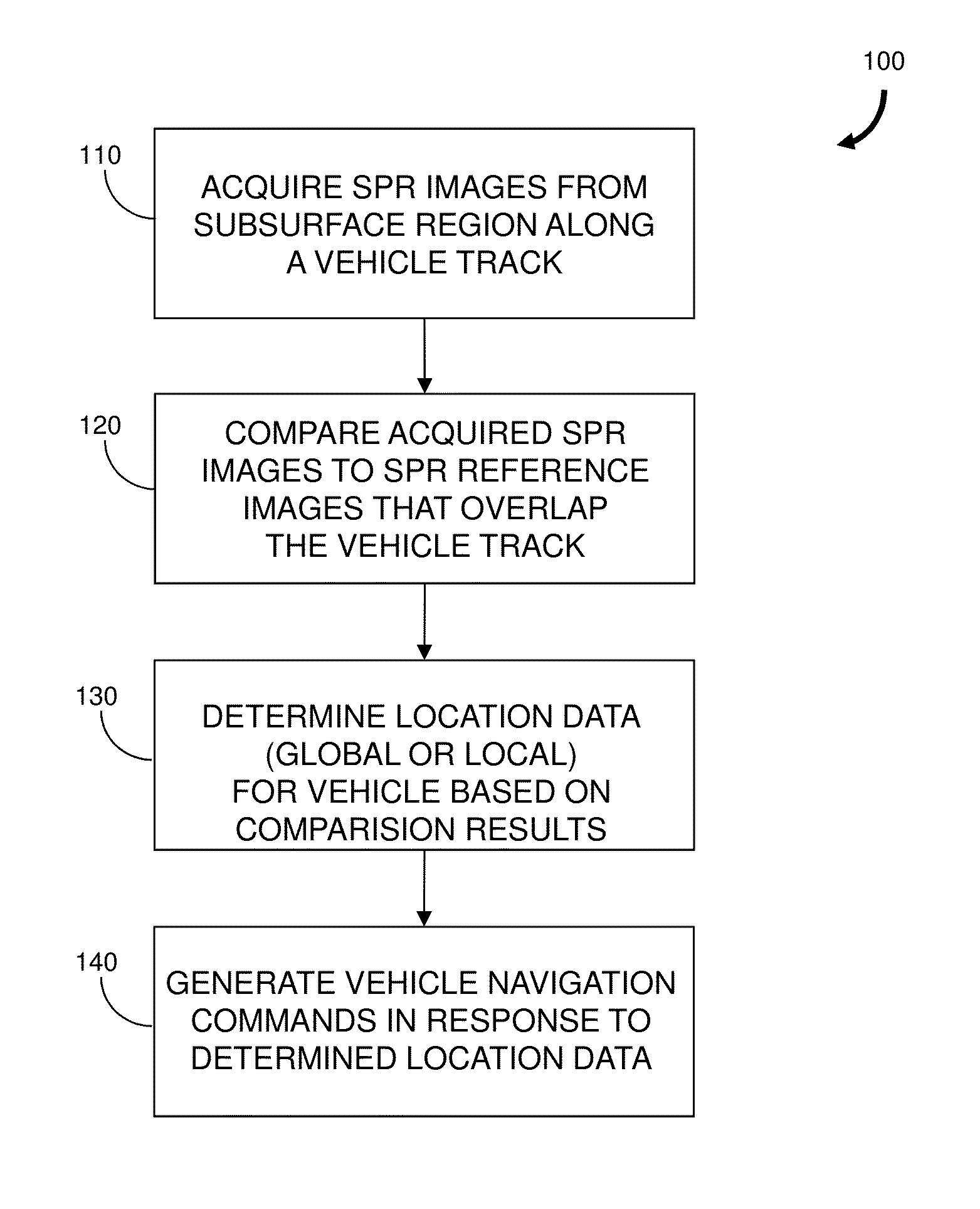
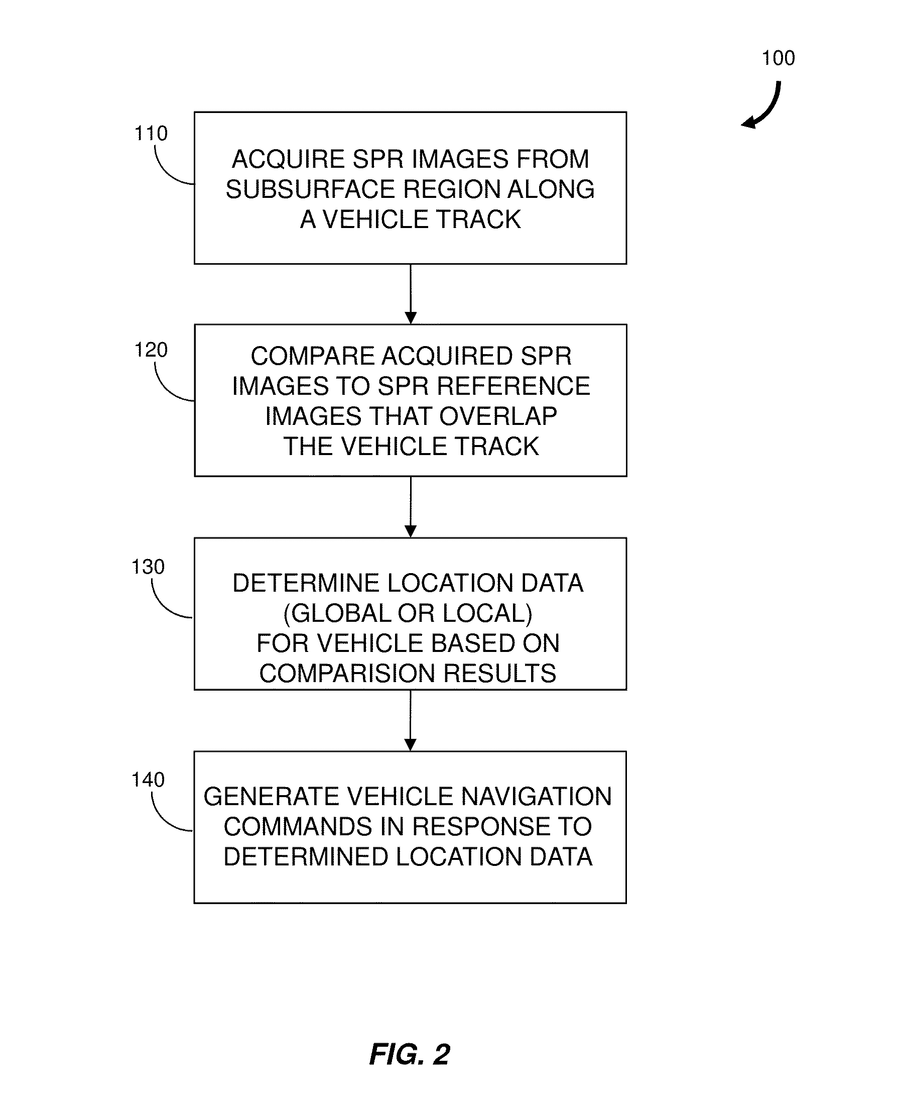
The first category presents a challenging approach due to the extreme variability of real-world environments.
Results have demonstrated that the “rich map” approach to reliable autonomous navigation in structured, well-characterized terrain may be achievable; however, one of the substantial challenges to relying on a detailed prior map is that the system must maintain precise, accurate knowledge of the vehicle location within the map.
Traditionally, GPS receivers have been used to provide global localization; however, GPS alone does not provide the precision necessary to stay within a lane of traffic.
Furthermore, GPS accuracy degrades severely in environments with multipath or shadowing and the signals can easily be blocked or intentionally disrupted by others desiring to interfere with operation.
GPS-based systems can be improved with differential signal algorithms or by augmenting the location estimate with inertial sensors; however, the resulting systems are typically costly and may require additional infrastructure such as base stations.
Passive visual methods, for example, methods employing one or more digital video cameras, perform poorly in outdoor environments due to changes in scene illumination.
While the active sensing approach solves the problem of inconsistent scene illumination, difficulties are encountered when the apparent scene changes significantly with weather conditions.
Other weather conditions such as fog, rain and dust also impact performance.
Moreover, dynamic aspects of the observed scene can create further complications.
For example, the presence of other moving vehicles and the motion of typically static features due to wind gusts present significant challenges.
Thus, current sensing approaches for map-based localization are not robust to common real-world conditions.
Furthermore, active sensors such as those employing light detection and ranging (LIDAR) sensors generally require expensive precision-engineered electro-optical-mechanical systems.

Method used


Image

  • Vehicle localization using surface penetrating radar
  • Vehicle localization using surface penetrating radar
  • Vehicle localization using surface penetrating radar

Examples


Embodiment Construction

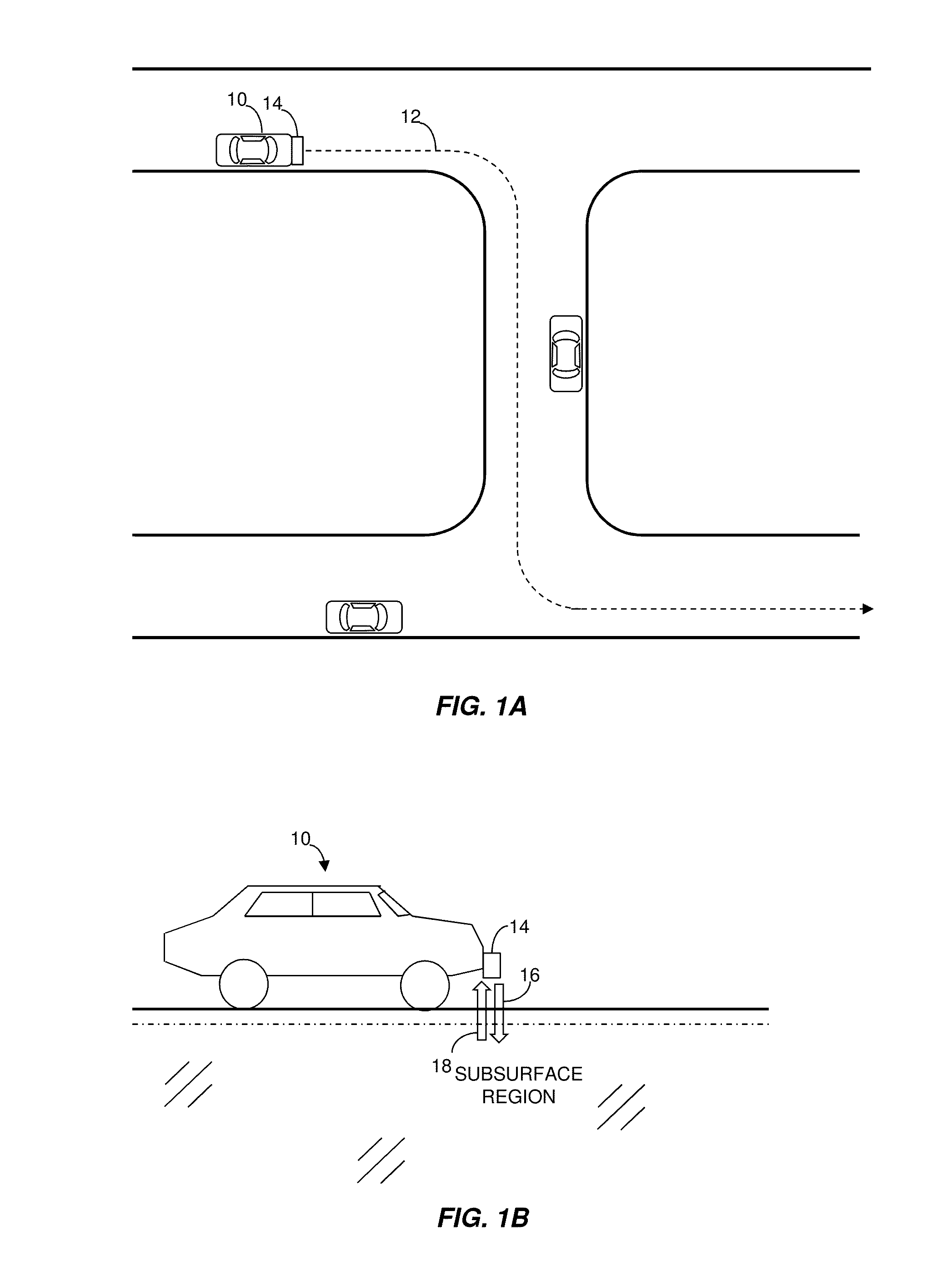
[0026]Reference is made in various embodiments described below to ground and to an underground region below the surface of the ground. It will be understood that the ground includes soil, road surface or pavement such as asphalt and concrete layers, gravel, sand and the like, and that the surface of the ground is the interface of the ground with the air, array, fluid or free space. In some instances, the surface may also include the surfaces that surround a tunnel, mineshaft and other passageways through which a vehicle may travel.

[0027]More generally, reference is made herein to surface penetrating radar (SPR) and ground penetrating radar (GPR). As used herein, SPR means any radar system that is configured to acquired data from a subsurface region. A SPR can be configured and oriented to obtain data for a subsurface region that is behind the surface of a wall, ceiling, floor or the surface surrounding a tunnel or passageway. In some instances the SPR can also obtain data for the su...


PUM


Abstract

Described are a method and a system for localization of a vehicle. The method includes the acquisition of SPR images of a subsurface region along a vehicle track. Acquired SPR images are compared to SPR images previously acquired for a subsurface region that at least partially overlaps the subsurface region along the vehicle track. In some embodiments, the comparison includes an image correlation procedure. Location data for the vehicle are determined based in part on location data for the SPR images previously acquired for the second subsurface region. Location data can be used to guide the vehicle along a desired path. The relatively static nature of features in the subsurface region provides the method with advantages over other sensor-based navigation systems that may be adversely affected by weather conditions, dynamic features and time-varying illumination. The method can be used in a variety of applications, including self-driving automobiles and autonomous platforms.

Description

RELATED APPLICATIONS[0001]This application claims the benefit of the earlier filing dates of U.S. Provisional Patent Application No. 61 / 718,363, filed Oct. 25, 2012 and titled “Method of Localization of a Vehicle Using Ground Penetrating Radar” and U.S. Provisional patent Application No. 61 / 763,241, filed Feb. 11, 2013 and titled “Method of Localization of a Vehicle Using Surface Penetrating Radar,” the entireties of which are incorporated herein by reference.GOVERNMENT RIGHTS IN THE INVENTION[0002]This invention was made with government support under Grant No. FA8721-05-C-0002 awarded by the Air Force. The government has certain rights in this invention.FIELD OF THE INVENTION[0003]The present invention relates generally to a method and system for localization of a vehicle. More particularly, the invention relates to localization of a vehicle using surface penetrating radar and the option for using localization data for navigation of the vehicle.BACKGROUND OF THE INVENTION[0004]Appr...

Claims


Application Information

Patent Timeline
Patent Type & Authority Patents(United States)
IPC IPC(8): G01S13/88G01S13/06G01S13/87G05D1/02
CPCG05D1/0257G01S13/87G01S13/06G05D1/0268G05D2201/0213G01C21/30G01S13/885G01S13/89G01S13/605
Inventor STANLEY, BYRON MCCALLCORNICK, MATTHEW TYLERCOLDWELL, CHARLES MICHAELKOECHLING, JEFFREY CHARLESZHANG, BEIJIA
Owner MASSACHUSETTS INST OF TECH
Why Eureka
Try Eureka