
SINS/CNS/GPS Combined navigation semi-entity copying system

A semi-physical simulation and integrated navigation technology, which is applied in the field of semi-physical simulation system, can solve the problems of impracticability, poor versatility, and high cost, and achieve the effect of strong versatility

Inactive Publication Date: 2009-04-08
BEIHANG UNIV
View PDF2 Cites 1 Cited by
  • Summary
  • Abstract
  • Description
  • Claims
  • Application Information

AI Technical Summary

Problems solved by technology

Now the domestic SINS / GPS integrated navigation system has been well applied. For example, the SINS / GPS integrated navigation system produced by AVIC No. 1 Group 618 has been successfully applied to helicopters, while the SINS / CNS / GPS integrated navigation system is limited to digital simulation. In order to realize the SINS / CNS / GPS integrated navigation hardware-in-the-loop system, it is necessary to carry out experimental verification on the aircraft, which is not only costly, but also poor in versatility, so it cannot be realized
Use SINS, CNS, and GPS systems to perform combined calculations after collecting data. When simulating aircraft movement, because the CNS system cannot realize the related movement and identification of star maps, it can only be static simulation or post-processing, and SINS / CNS / Real-time dynamic simulation of GPS integrated navigation hardware-in-the-loop system

Method used


Image

  • SINS/CNS/GPS Combined navigation semi-entity copying system
  • SINS/CNS/GPS Combined navigation semi-entity copying system
  • SINS/CNS/GPS Combined navigation semi-entity copying system

Examples


Embodiment Construction

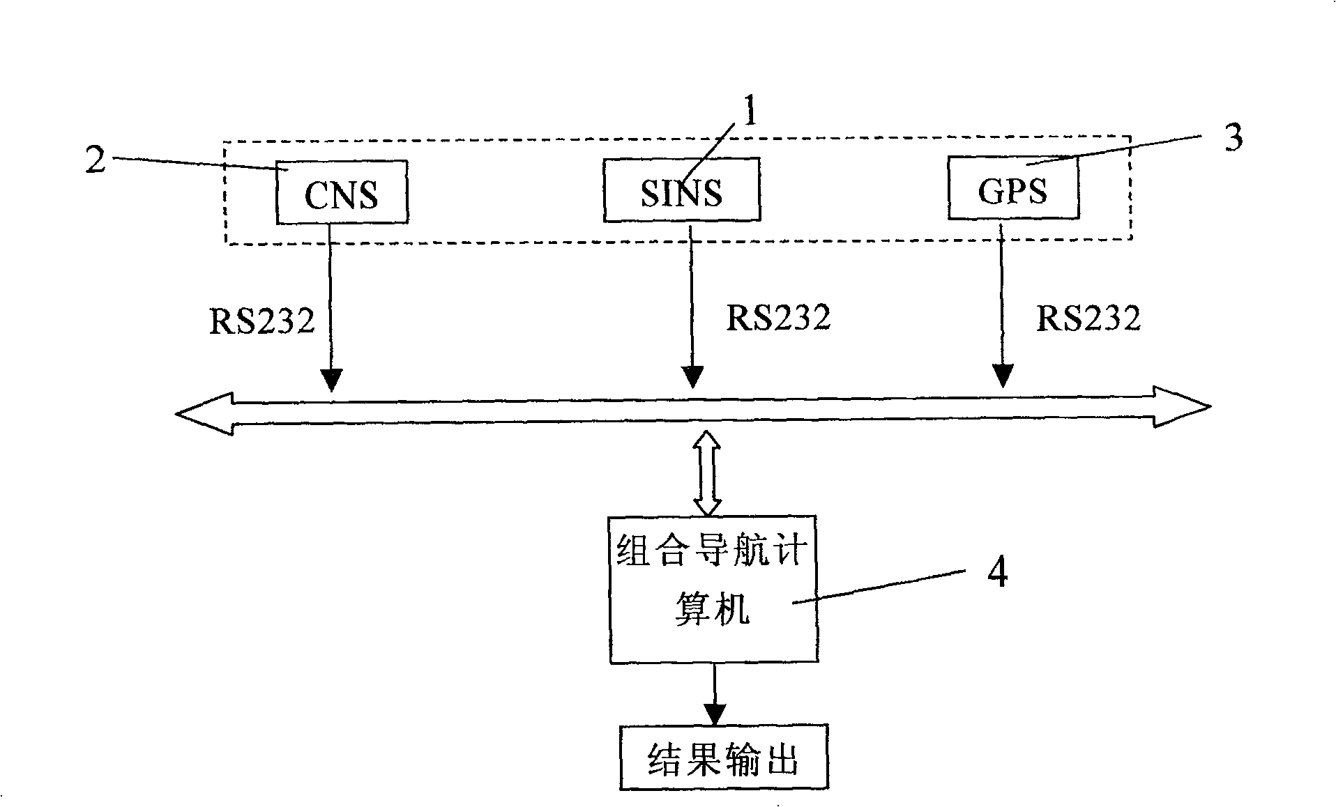
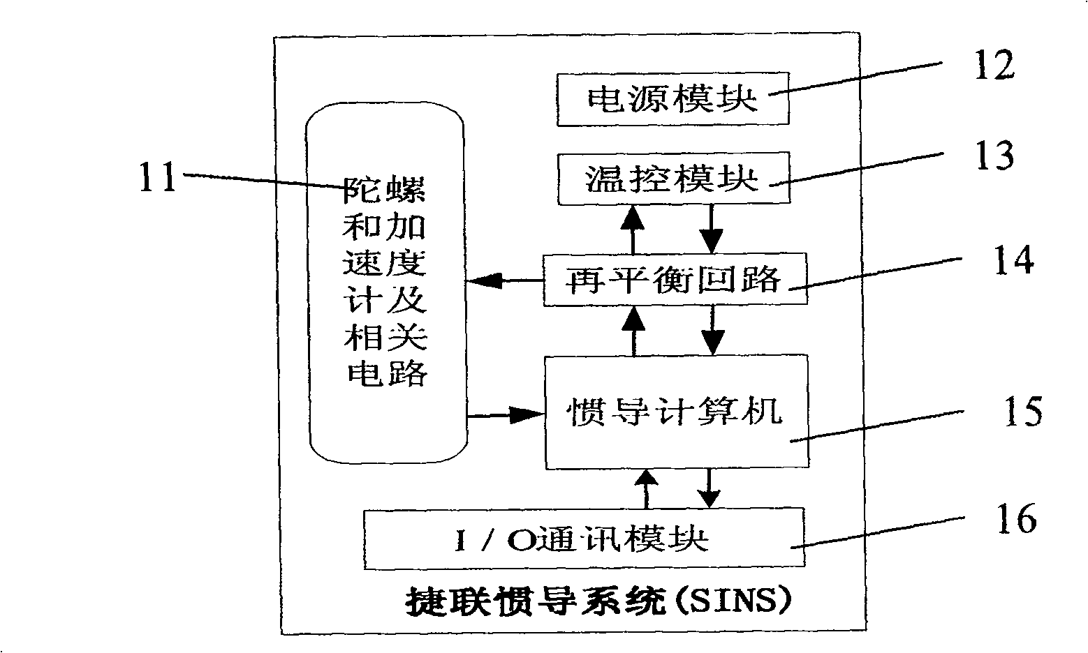
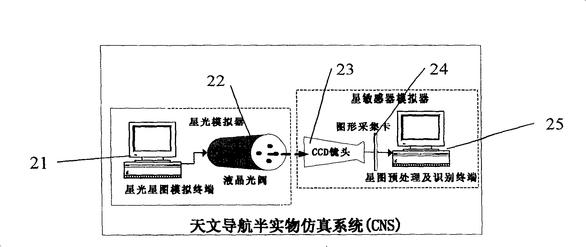
[0014] Such as figure 1 Shown, the present invention is made up of SINS subsystem 1, CNS subsystem 2, GPS subsystem 3, integrated navigation computer 4, and the trajectory generator in the integrated navigation computer 4 generates SINS subsystem 1, CNS subsystem 2 and The nominal trajectory data of the GPS subsystem 3, including the position, speed, and attitude standard data of the aircraft trajectory, are stored in the navigation computer 4, and the SINS subsystem 1 and the GPS subsystem 3 collect the data to obtain a semi Physical simulation system data, CNS subsystem 2 realizes dynamic star map generation and identification according to the nominal data generated by the orbit generator, and generates semi-physical simulation data with real device error characteristics. The device error characteristics are superimposed on the nominal data generated by the trajectory generator in the integrated navigation computer 4, and the integrated navigation computer 4 performs SINS / CN...


PUM


Abstract

The invention is a SINS / CNS / GPS combined-navigating half-entity simulating system, comprising SINS, CNS and GPS subsystems, combined navigating computer and track generator, using SINS and GPS entity systems, star map simulator and star sensor simulator entity as physical models, combined navigating computer, where the combined navigating computer adopts PC104 embedded microcomputer, the track generator software produces nominal track data, and dynamic characteristics of the system adopt digital model and it performs SINS / CNS / GPS combined navigating operation in the combined navigating computer to complete SINS / CNS / GPS combined navigation. And it effectively reduces testing cost and shortens development cycle.

Description

technical field [0001] The invention relates to a semi-physical simulation system, in particular to a SINS / CNS / GPS combined navigation semi-physical simulation system, which completes the semi-physical simulation of the SINS / CNS / GPS combined navigation system and is suitable for research on the combined navigation system. Background technique [0002] The navigation system has penetrated deep into life, and all countries have invested a lot of manpower and material resources in research. It has broad application prospects in aerospace, transportation and other fields. In the process of navigation technology research and system design, simulation technology has high scientific value and huge economic benefits, semi-physical simulation is particularly important, especially in the development process of navigation system, it is the authoritative test second only to flight test identification method. Advanced aircraft navigation system, in its design and finalization process, ...

Claims


Application Information

Patent Timeline
Patent Type & Authority Patents(China)
IPC IPC(8): G06G7/78
Inventor 房建成徐帆全伟盛蔚刘百奇杨胜
Owner BEIHANG UNIV
Learn More