Method for extracting geoscience spatial information based on generalized self-similarity principle

A self-similarity, spatial information technology, applied in the field of geospatial information, can solve the problems of geospatial information processing and extraction accuracy and precision reduction, and achieve the effects of reducing boundary effects, high extraction precision, and improved accuracy

Inactive Publication Date: 2009-08-12
成秋明 +3
View PDF0 Cites 14 Cited by
  • Summary
  • Abstract
  • Description
  • Claims
  • Application Information

AI Technical Summary

Problems solved by technology

[0007] However, because the S-A method transforms the spatial information into the frequency domain through Fourier transform and performs filtering operations on it, this method has some disadvantages of Fourier transform, such as the boundary of the Fourier transform two-dimensional space image will be Boundary effects, such as two vertical and horizontal bands in the central area of ​​the energy spectrum plane, are often caused. These noises caused by boundary effects will affect subsequent operations, which will lead to the accuracy and precision of geospatial information processing and extraction. reduce

Method used


Image

  • Method for extracting geoscience spatial information based on generalized self-similarity principle
  • Method for extracting geoscience spatial information based on generalized self-similarity principle
  • Method for extracting geoscience spatial information based on generalized self-similarity principle

Examples


Embodiment Construction

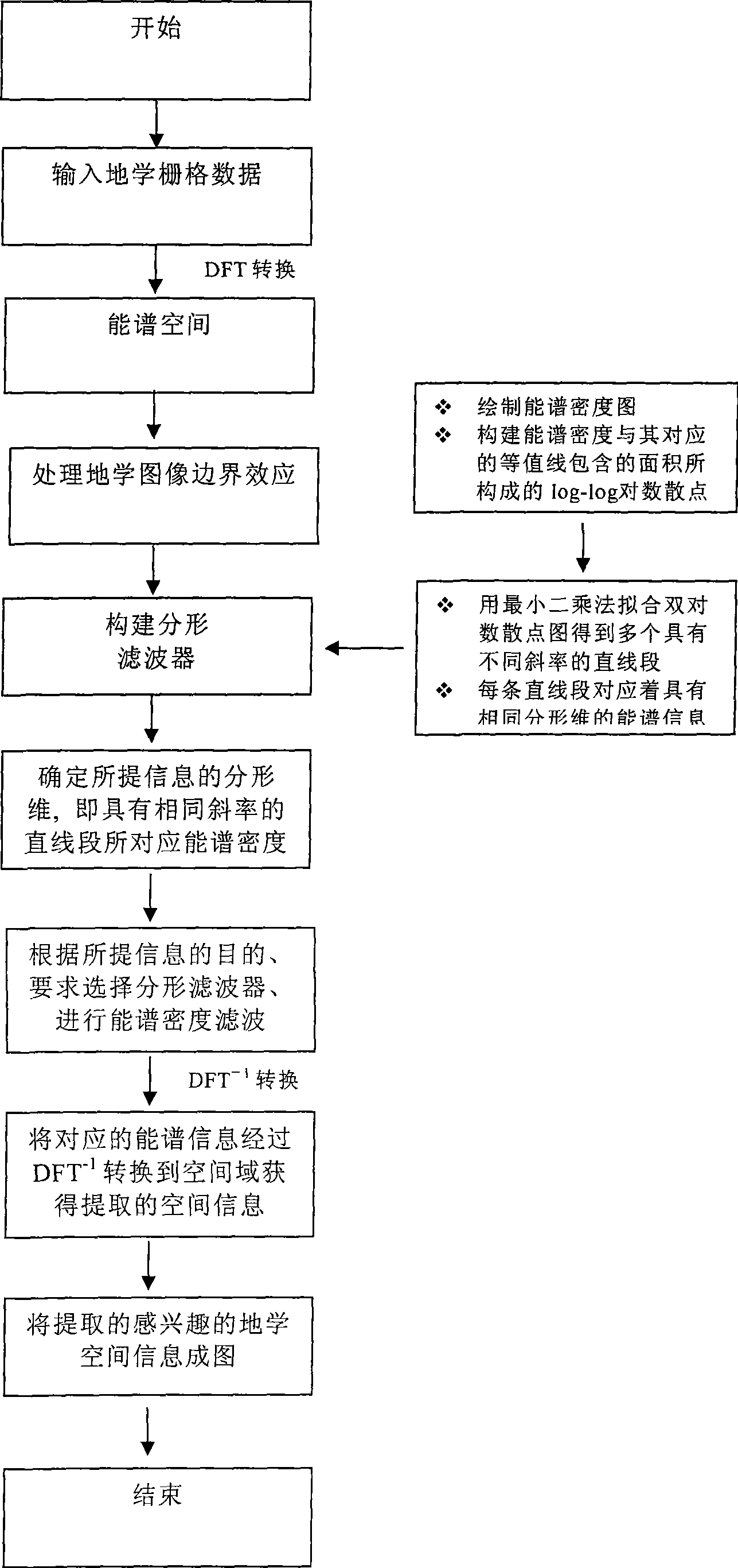
[0033] Such as figure 1 As shown, the specific implementation steps of the present invention are as follows:

[0034] The first step is to preprocess the data and convert the geospatial data to be processed into raster data;

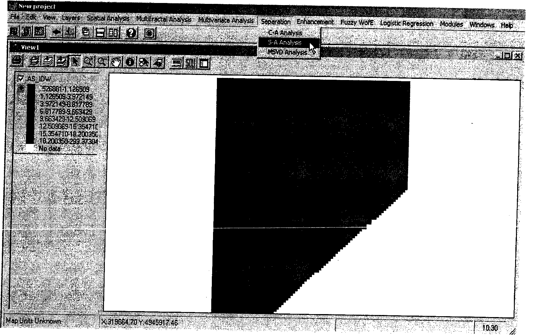
[0035] First, prepare the data, select the geoscience data to be analyzed, and convert the collected geoscience data, such as point data, image data (TIF, JPG, BMP) and other file formats, to the raster data file format through interpolation and format conversion. These methods It is available in some commonly used commercial GIS software, such as ArcGIS. E.g, figure 2 It is a raster data image obtained by sampling and interpolation of lake sediments of the metallic element arsenic, named AS_IDW.

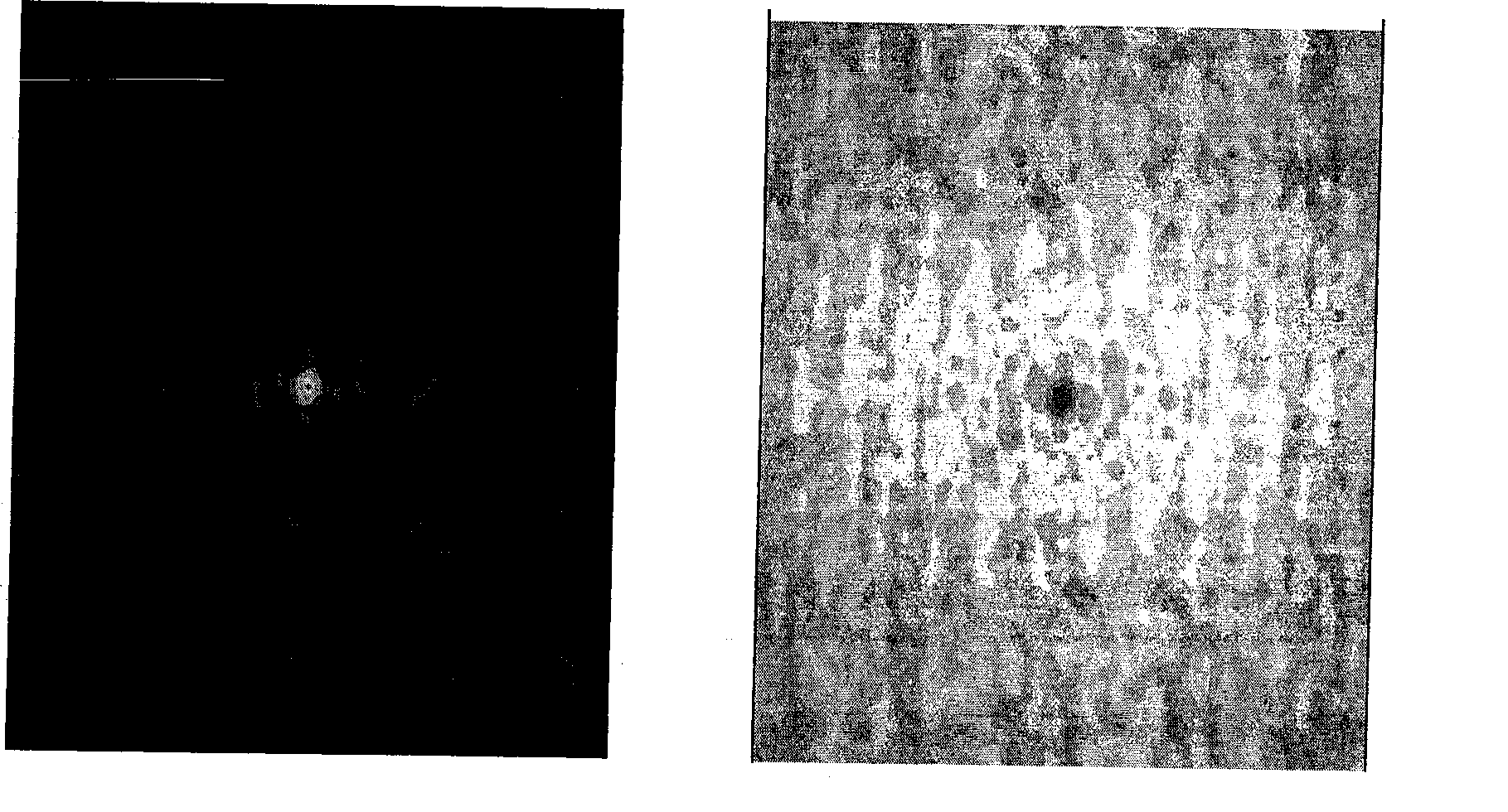
[0036] In the second step, the Fourier transform is used to transform the raster data into the energy spectral density space, while reducing the influence of the boundary effect caused by the Fourier transform.

[0037] In this step, Fourier transform is applied...


PUM


Abstract

The invention relates to a method for extracting topographical spatial information based on a generalized self-similarity principle, which comprises: transforming the topographical spatial information into an energy spectral density space by Fourier transformation; eliminating the influence of boundary effect generated by the topographical data boundary part; drawing a double logarithmic scatter graph formed by the energy spectral density value (S) and the area (A) included by the isometric line of the energy spectral density value (S), and detecting the fractal rules of the energy spectral density and the area; determining the number and the interval of generalized self-similarity relations; determining the threshold and a corresponding fractal filter; and transforming filtered energy spectrum information back to a spatial domain by inverse Fourier transformation, and achieving the aims of decomposing anomaly and ambient fields and extracting interested topographical spatial information. The method has the advantages of wide practicality, high extraction precision and the like, and is suitable for topographical data such as geological data, mineral data, geochemical data, geophysical data, remote sensing data and the like, and the operations of topographical information extraction and topographical data mining such as mineral exploration, resource assessment, environmental pollution assessment, natural disaster analysis, marine vortex extraction and the like.

Description

Technical field [0001] The invention relates to a method for extracting geospatial information based on the principle of generalized self-similarity, and belongs to the technical field of geospatial information. technical background [0002] The process of extracting required spatial patterns (images) from geological data, such as environmental data, geological data, mineral data, geochemical data, geophysical data, and remote sensing data, is the process of geospatial information extraction. The data processing and information extraction methods adopted for different geoscience data sources and different needs are also different. For example, using multi-temporal remote sensing data to extract land use changes in Beijing from 1995 to 2000, the methods adopted here are mainly remote sensing image change detection technology. For another example, using remote sensing data to extract ocean vortex information, commonly used extraction techniques include (1) using similarity for fing...

Claims


Application Information

Patent Timeline
Patent Type & Authority Applications(China)
IPC IPC(8): G06F17/30G06F17/14
CPCY02A90/10
Inventor 成秋明许亚光张生元葛咏
Owner 成秋明
Why Eureka
Try Eureka