
Physical distribution geographical information system

A geographic information system and logistics technology, applied in the field of logistics geographic information system, logistics teaching and training, can solve problems such as undiscovered systems, and achieve the effect of convenient teaching

Inactive Publication Date: 2009-08-26
SHANGHAI MARITIME UNIVERSITY
View PDF0 Cites 6 Cited by
  • Summary
  • Abstract
  • Description
  • Claims
  • Application Information

AI Technical Summary

Problems solved by technology

Through document retrieval, on-the-spot research and other work, it is found that there are few reports and discussions on "logistics geographic information system" at home and abroad, and no system that has been put into use has been found. The necessity and innovation of the present invention are obvious

Method used


Image

  • Physical distribution geographical information system
  • Physical distribution geographical information system
  • Physical distribution geographical information system

Examples


Embodiment

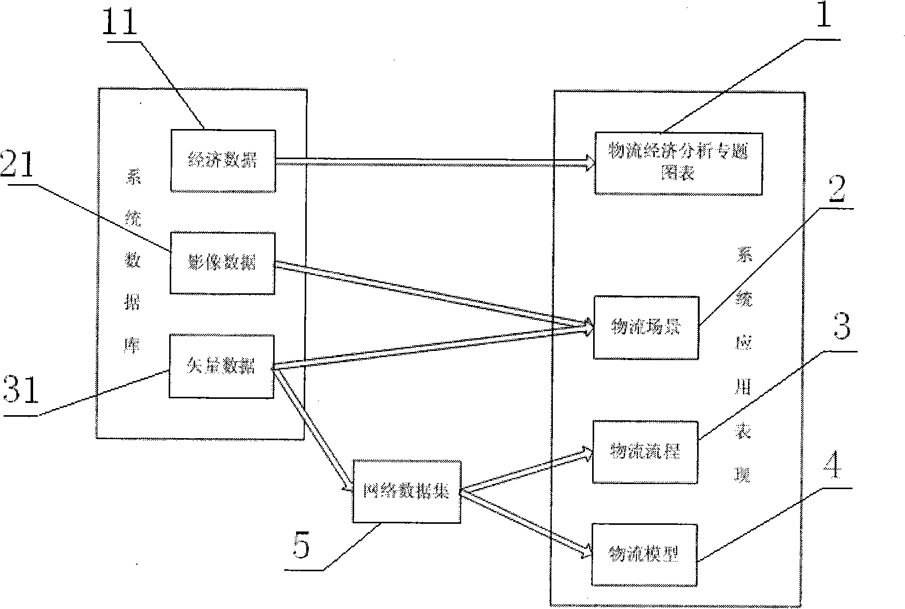
[0038] see again figure 1 : The implementation method of logistics geographic information system combines geographic information system and logistics professional characteristics and advantages, and its specific steps are:

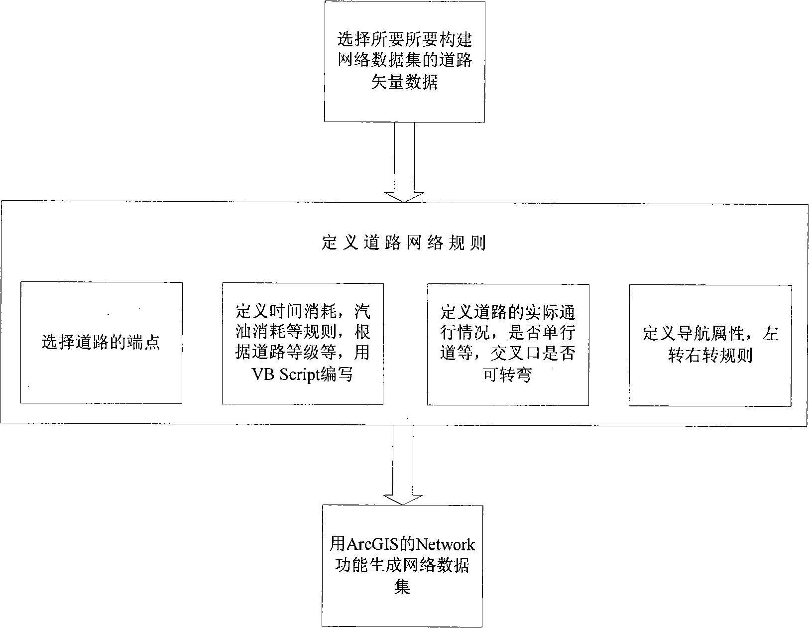
[0039] (1) Data collection and storage, including vector, image and attribute data, including natural geographic information, economic geographic information, administrative and legal geographic information, logistics outlets, sea, land and air transportation networks, logistics-related enterprises, groups, institutions and The distribution of influence on the map, three-dimensional legends of logistics facilities such as ships (cargo compartments), aircraft (cargo compartments), containers, containers, and waterways, business-related logistics routes, nodes and areas (can be simulated data), specific ports The detailed structure of the district, the layout of functional nodes of a specific enterprise, etc., all data are managed by the Oracle11g database s...


PUM


Abstract

The invention relates to a physical distribution geographical information system which comprises various physical distribution models, physical distribution process flow, physical distribution scene and a physical distribution economic analysis special subject diagram; on the basis of network dataset, the physical distribution models can obtain optimized results on the actual path and show the results; on the basis of network data acquisition, the physical distribution process flow can make dynamic simulation on the actual path; based on vector data and image data, a plurality of typical physical distribution scenes can be shown on a computer screen; on the basis of physical distribution economic data, ten thousand years of physical distribution economic data can be displayed by the physical distribution economic analysis special subject diagram to the user in a form of diagram. The physical distribution process flow and the physical distribution models are set up on the generated network dataset. The invention can be applied to the teaching of the interrelated specialized field of physical distribution, the training and the like, leads teaching and studying to be more visualized and is beneficial to better acquiring and studying physical distribution geographical knowledge by the student.

Description

technical field [0001] The invention relates to a logistics geographic information system, which is applied in the field of logistics, especially in logistics teaching and training related to spatio-temporal logistics information. Background technique [0002] Modern logistics science has undergone a fundamental revolution, and goods are now moving more efficiently, faster and more effectively monitored across the globe. In recent years, many entities involved in the supply chain and logistics industry have carried out a series of project research and development to improve production capacity and production efficiency in order to increase profits. In fact, logistics also involves the field of geographical location information. Through location transformation and transportation, sometimes manpower or material costs can be greatly saved. The existing geographic information system is already a very mature technology. The combination of logistics science can make the logistics...

Claims


Application Information

Patent Timeline
IPC IPC(8): G06Q10/00G06Q50/00G06Q10/08G06Q50/28
Inventor 黄有方杨斌王洁胡坚堃吴先斌孟燕萍
Owner SHANGHAI MARITIME UNIVERSITY
Learn More