Large-scale terrain rendering system based on double-layer nested grid

A large-scale terrain and double-layer nesting technology, applied in the field of virtual reality, can solve the problems of triangle patch redundancy and long preprocessing time, achieve stable frame rate, avoid real-time scheduling, and smooth visual experience

Inactive Publication Date: 2009-12-02
BEIHANG UNIV
View PDF0 Cites 15 Cited by
  • Summary
  • Abstract
  • Description
  • Claims
  • Application Information

AI Technical Summary

Problems solved by technology

The Chunked LOD algorithm also has the following disadvantages: the preprocessing time is relatively long; the terrain data must be static; compared with other LOD algorithms, under the same screen error measurement, the number of triangles has greater redundancy; for processable data The amount has a certain upper limit, although this upper limit is user-controllable

Method used


Image

  • Large-scale terrain rendering system based on double-layer nested grid
  • Large-scale terrain rendering system based on double-layer nested grid
  • Large-scale terrain rendering system based on double-layer nested grid

Examples


Embodiment Construction

[0019] The concrete implementation method of the present invention is as follows:

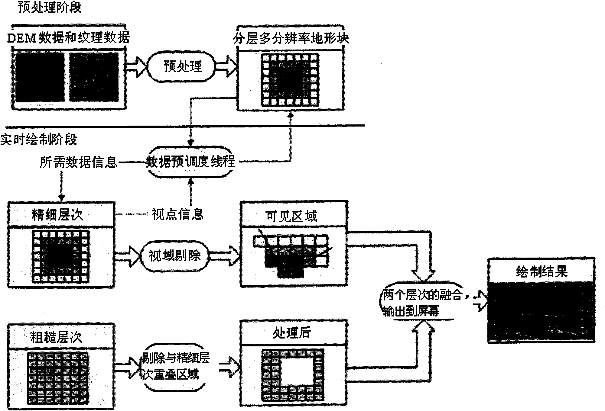
[0020] The frame diagram of the terrain scene system realized by this method is as follows: figure 1 shown. In the preprocessing stage, we need to process the fine-level and coarse-level data separately. We control the resolution of the coarse level within a certain threshold, store it, and load it into memory before real-time rendering starts. Fine-level hierarchical blocks are stored (step 1). In the real-time rendering stage, first build a two-layer model (step 2), and then draw the coarse layer and the fine layer separately, we need to do some processing on the fine layer, including the elimination of T connections (step 3), viewshed culling (step 4) and geometry transition (step 5), and finally, we blend the two layers of terrain on the GPU (step 6). Before the next frame of drawing starts, we need to update the terrain (step 7) and enter the next frame of drawing.

[0021] In step 1,...


PUM


Abstract

The invention relates to a large-scale terrain rendering system based on a double-layer nested grid. The system consists of a preprocessing module and a real-time rendering module, wherein the preprocessing module carries out off-line preprocessing on DEM data and texture data needed when in rendering; a resolution ratio of a coarse layer is controlled within a certain threshold value and stored; layering and partitioning processing is carried out on a precise layer, and the processed terrain block data are stored in an external memory; and the real-time rendering module takes charge of real-time rendering of large-scale terrain, and the module also comprises a scene model rendering submodule and a scene model updating submodule. The scene model rendering submodule has the functions of T connection elimination, vision field rejection, geometric transition and fusion of the two layers; and the scene model updating submodule changes the fine degree of all terrain areas according to the change of viewpoints and controls the pre-dispatch of terrain mass data. The scene model rendering submodule and the scene model updating submodule are divided into two threads to be executed so as to obviously improve the rendering speed of large-scale terrain scenes.

Description

technical field [0001] The invention relates to a large-scale terrain rendering system based on double-layer nested grids, and belongs to the technical field of virtual reality. Background technique [0002] Large-scale terrain mapping has a wide range of applications in both military and civilian applications. Whether it is military battlefield terrain environment simulation, flight training simulation, military command or civilian urban planning, petrochemical industry, graphics engine, large-scale terrain rendering is an essential part of it. [0003] Extensive research has been carried out on real-time rendering of large-scale terrain at home and abroad. Among the mainstream terrain algorithms, they can be divided into two categories according to the generated grids: algorithms based on irregular triangular grids and algorithms based on regular grids. . Algorithms based on meshes of irregular triangles generate meshes directly from vertices satisfying importance condit...

Claims


Application Information

Patent Timeline
IPC IPC(8): G06T15/10G06T17/50G06T1/60G06T17/05
Inventor 何兵隋雷赵沁平郝爱民王莉莉
Owner BEIHANG UNIV
Why Eureka
Try Eureka