Method for extracting contour of building by integrated images and LiDAR data

A data extraction and building technology, applied in image data processing, image analysis, photo interpretation, etc., can solve the problems of low resolution, insufficient fineness and low precision of building outlines, and achieve the effect of high positioning accuracy

Inactive Publication Date: 2009-12-16
WUHAN UNIV
View PDF0 Cites 39 Cited by
  • Summary
  • Abstract
  • Description
  • Claims
  • Application Information

AI Technical Summary

Problems solved by technology

Generally speaking, with the current technical level, the point spacing of airborne LiDAR data is about meter-level. Compared with aerial high-resolution images that can reach centimeter-level resolution, the spatial resolution of LiDAR data is relatively low. The building outlines obtained from the data are often not fine enough and the accuracy is not high
Using regularization technology can improve the accuracy of the contour line, but the regularization method is also limited by the spatial resolution of LiDAR points and the accuracy of filtering, classification, etc., there is uncertainty and it is easy to cause the overall deviation of the contour line

Method used


Image

  • Method for extracting contour of building by integrated images and LiDAR data
  • Method for extracting contour of building by integrated images and LiDAR data
  • Method for extracting contour of building by integrated images and LiDAR data

Examples


Embodiment

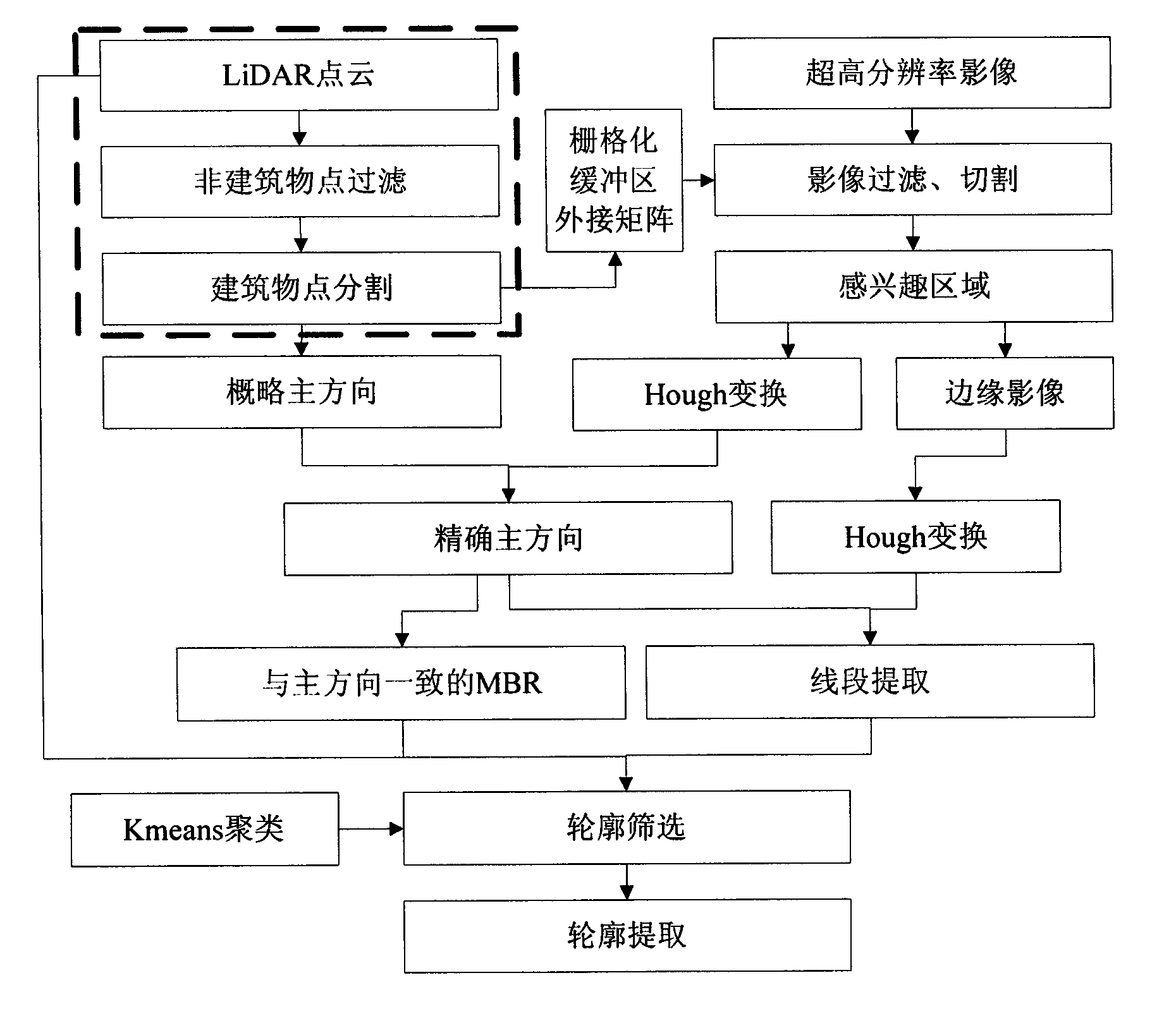
[0018] The flow chart of the method for integrating images and LiDAR data to extract building outlines is shown in the accompanying drawing, including the following steps

[0019] (1) Pretreatment

[0020] Separate the building points and non-building points in the LiDAR point cloud, and divide the building points to form a point set for each building. The separation of the point cloud first eliminates most of the trees based on the two reflection data; then detects the terrain to obtain the DEM through the linear prediction method, and deletes the ground points to obtain the building points with noise; finally, eliminates the fragments through the area control to obtain building points. Segmentation of building points can be done using the region growing method introduced in (Sampath and Shan 2007). The full automation of the preprocessing link is still technically difficult, and the general strategy is to carry out some manual editing on the basis of the automatic processi...


PUM


Abstract

The invention discloses a method for extracting the contour of a building by integrated images and LiDAR data. The method includes (1) pretreatment of LiDAR point cloud data; (2) establishment of a contour extraction area; (3) extraction of a building line segment; and (4) screening of the building contour. The invention can effectively extract the contour of a building with complex structure, the positioning accuracy is in proportion to in proportion to the LiDAR scheme, the rates of accuracy and integrity are high, and the robustness is favorable.

Description

technical field [0001] The invention relates to a method for integrating image and LiDAR data to extract building outlines, and belongs to the technical field of satellite remote sensing image and LiDAR data processing. Background technique [0002] Building model reconstruction has always been a research hotspot in the fields of surveying, mapping and remote sensing. At this stage, digital photogrammetry technology and airborne LiDAR technology (LiDAR) are the two most commonly used methods for obtaining 3D building models. However, "for all kinds of buildings, no modeling technology can meet the requirements of automation, high precision, flexibility and high efficiency, and low price at the same time." Integrating multi-source data, giving full play to their respective advantages and complementing each other, is a building The inevitable trend of model reconstruction. Therefore, there is an urgent need for a highly automated, more accurate, more detailed, low-cost, flex...

Claims


Application Information

Patent Timeline
Patent Type & Authority Applications(China)
IPC IPC(8): G06T7/60G01C11/04G01S17/89G01S7/48
Inventor 龚健雅程亮眭海刚孙开敏
Owner WUHAN UNIV
Why Eureka
Try Eureka