Storage and real-time visualization implementation method of mass cloud data

A technology of point cloud data and cloud data, applied in the field of geospatial information systems, can solve the problems of unable to dynamically change the displayed details, data loading failure, insufficient memory capacity, etc., to achieve real-time visualization, simple methods, and high execution efficiency Effect

Inactive Publication Date: 2009-12-30
常熟市广播电视总台
View PDF0 Cites 36 Cited by
  • Summary
  • Abstract
  • Description
  • Claims
  • Application Information

AI Technical Summary

Problems solved by technology

The former cannot dynamically change the displayed details because the data loaded into the memory is the point that has been read out, while the latter needs to load all the data into the memory first. When performing real-time visualization of massive point clouds, it is often due to Insufficient memory capacity causes data loading to fail

Method used


Image

  • Storage and real-time visualization implementation method of mass cloud data
  • Storage and real-time visualization implementation method of mass cloud data
  • Storage and real-time visualization implementation method of mass cloud data

Examples


Embodiment Construction

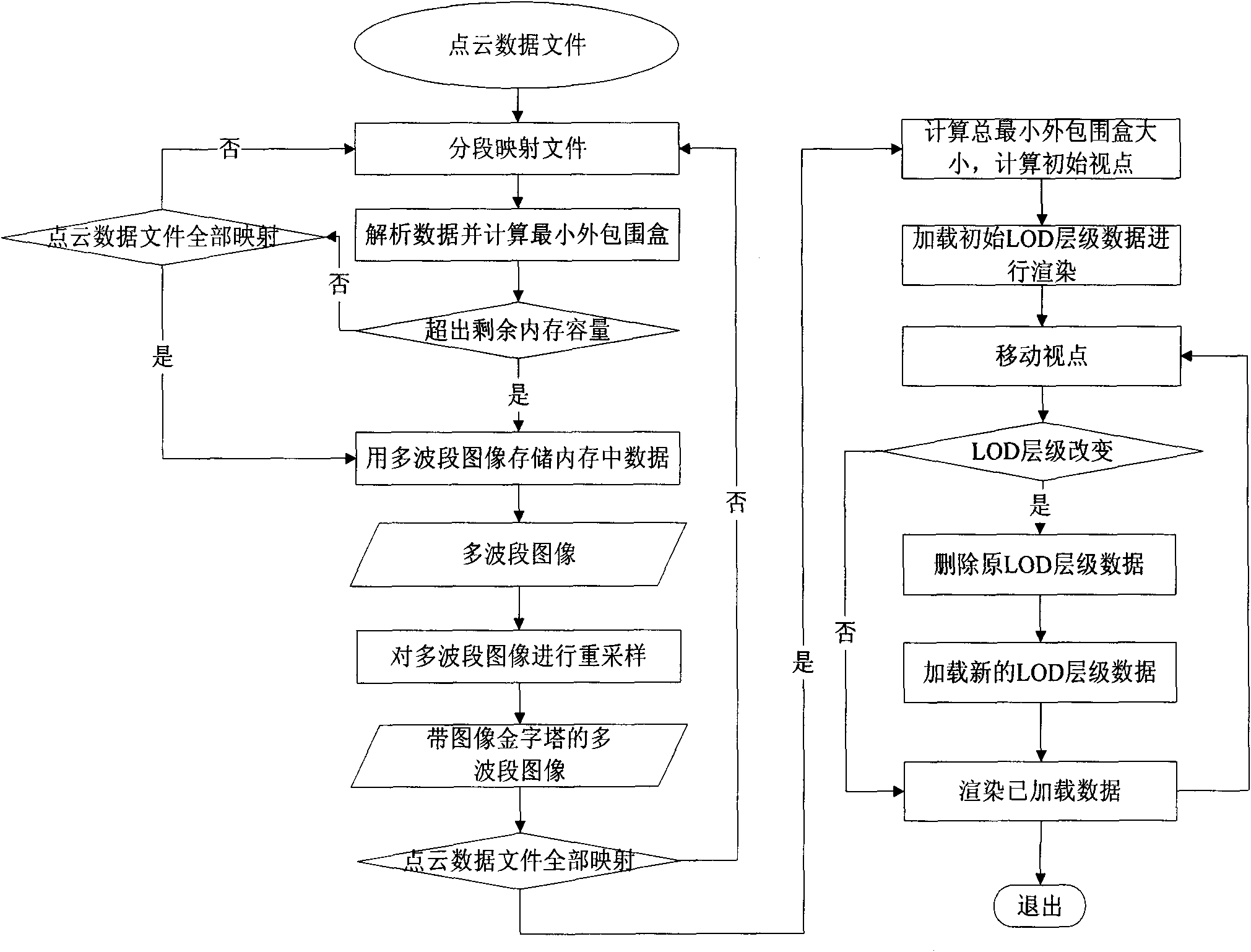
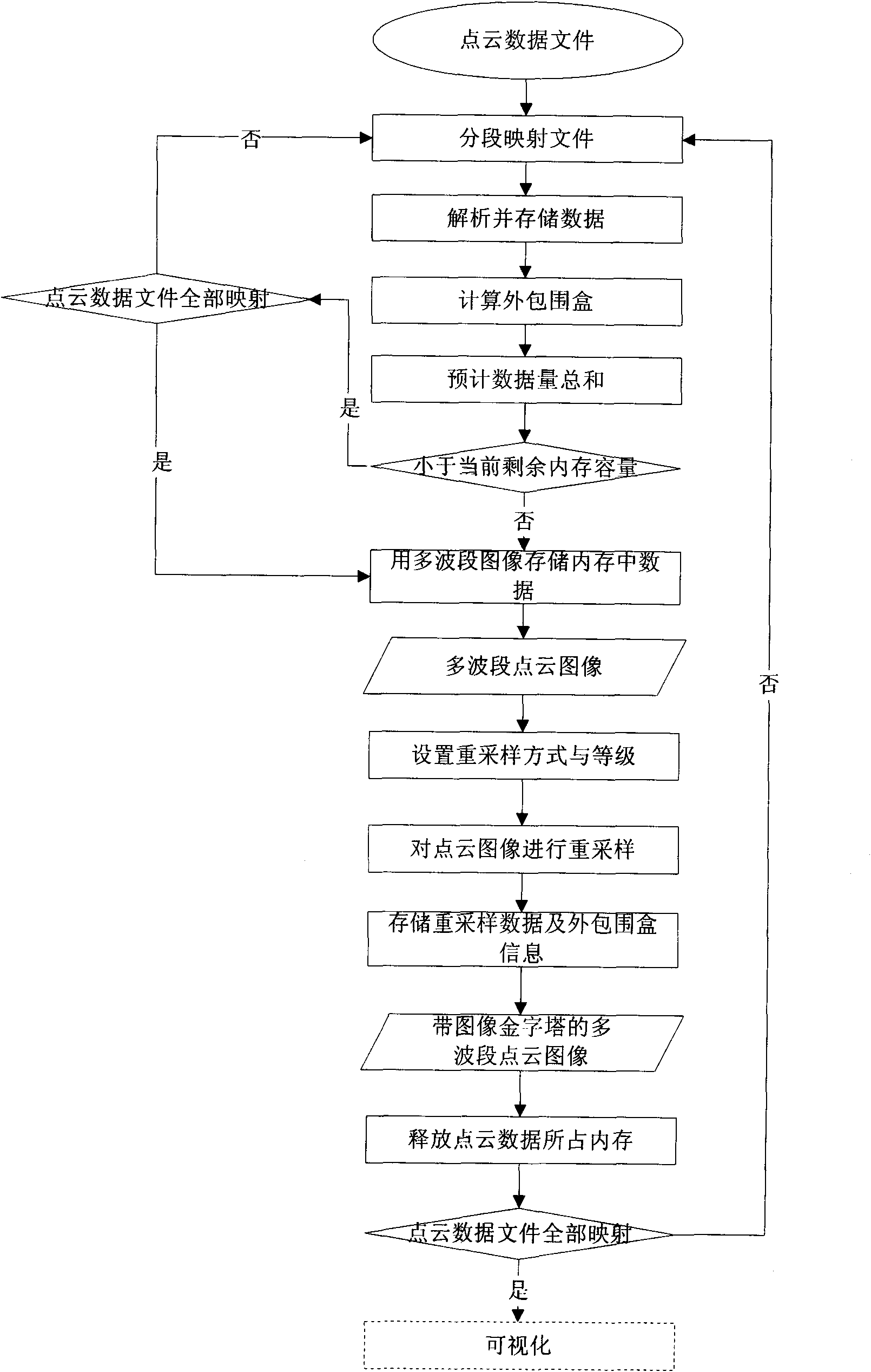
[0029] In the technical solution of the present invention, after the massive point cloud data is stored as a multi-band graphic file, the real-time visualization of the massive point cloud data is realized by processing the multi-band graphic file. These two processes can be implemented separately, and the geographic data provider stores massive point cloud data, and realizes real-time visualization when users need to view virtual images. In order to facilitate understanding of the present invention, figure 1 The overall flow of automatic processing using computer technology is provided as follows:

[0030] The realization of mass point cloud data storage includes the following steps,

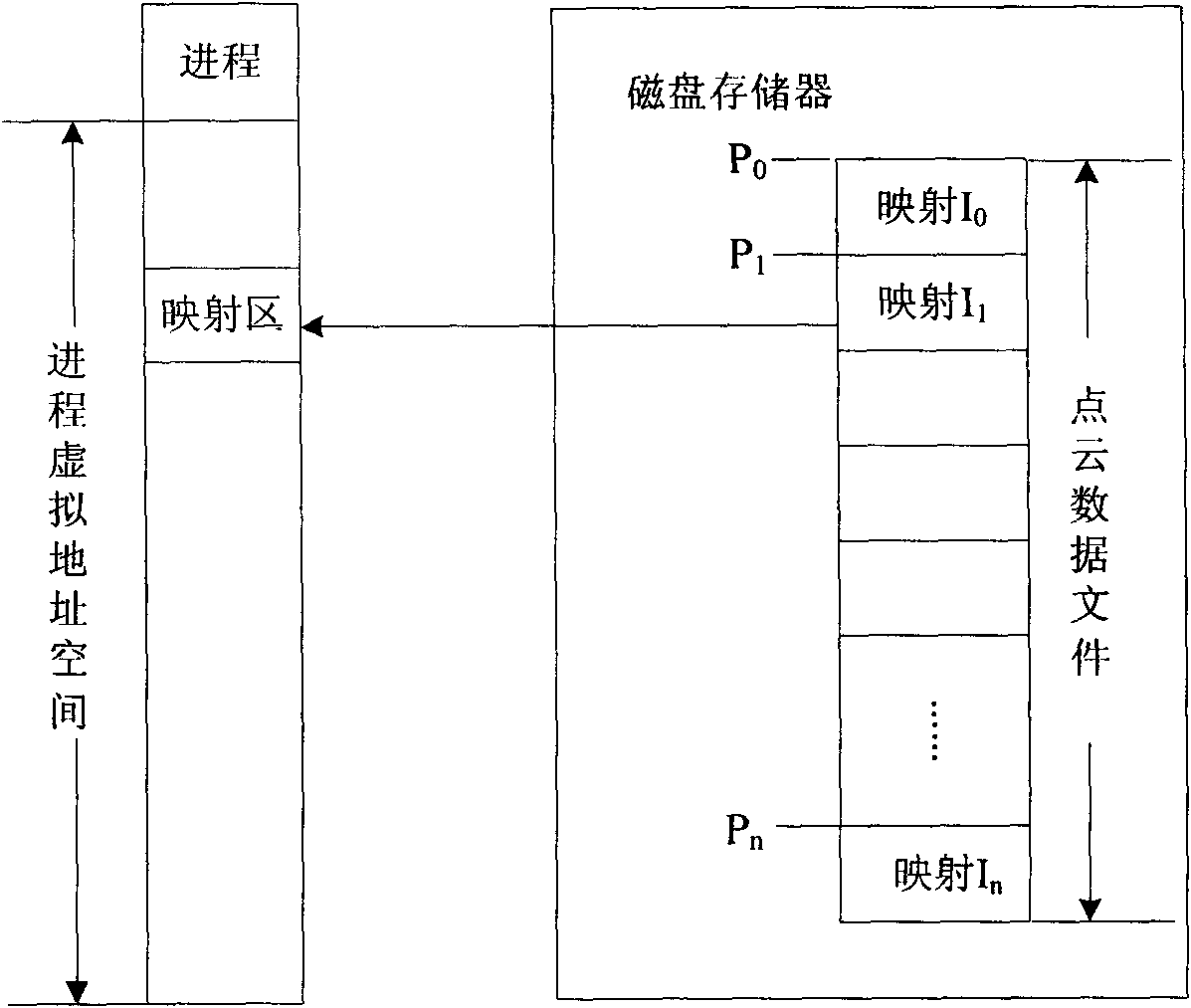
[0031] Step 1.1, while opening the point cloud data file in the computer, obtain the remaining memory capacity of the computer system, and determine the maximum amount of data for each mapping according to the capacity;

[0032] Step 1.2, take a segment from the point cloud data file and map ...


PUM


Abstract

A storage method of mass cloud data comprises the steps of segmenting a mass cloud data file continuously and mapping the mass cloud data file into a process virtual address space in sequence; analyzing and storing the mass cloud data in a memory, and calculating the minimum external wrapping box of the cloud data; storing the cloud data as a multi-waveband image file when the cloud data in the memory exceeds the residual memory capacity; carrying out multi-segment re-sampling on the multi-waveband image file to construct an image pyramid; and repeating the above steps until the cloud data are all stored as multi-waveband images. A visualization implementation method of mass cloud data comprises the steps of reading all the multi-waveband images and calculating the minimum external wrapping box of all the cloud data, selecting proper level in the image pyramid according to the distance between a view point and the central point of the minimum external wrapping box so as to load data, and rendering the loaded cloud data; and switching the data according to the distance action range of the images of each layer in the image pyramid and the corresponding LOD layer level when the view point moves, and executing real-time rendering.

Description

technical field [0001] The invention belongs to the technical field of geospatial information systems, and in particular relates to a method for storing and real-time visualization of massive point cloud data. Background technique [0002] Laser scanning technology is a new type of high-precision and fast acquisition of three-dimensional geometric data of objects developed vigorously in the 1990s. It acquires the target by recording the direction of the laser pulse and calculating the return time difference (or phase difference) after being reflected by the target surface. The accuracy of the three-dimensional coordinates of the surface can generally reach millimeter level, which is characterized by fast acquisition speed and high data accuracy. Therefore, the point cloud data obtained by laser scanning has gradually been widely used in digital cultural relics, digital cities and other fields. Point cloud data directly based on sampling points has unique advantages in 3D da...

Claims


Application Information

Patent Timeline
IPC IPC(8): G06F17/30G06T1/60G06T17/00G06T15/00
Inventor 杜志强朱庆张叶廷李俏雄
Owner 常熟市广播电视总台
Why Eureka
Try Eureka