Combined navigation and photoelectric detection integrative system

A combined navigation and photoelectric detection technology, applied in navigation calculation tools, navigation through speed/acceleration measurement, etc., can solve problems such as complex structure, large volume and weight, and high cost

Inactive Publication Date: 2010-08-04
BEIHANG UNIV
View PDF1 Cites 29 Cited by
  • Summary
  • Abstract
  • Description
  • Claims
  • Application Information

AI Technical Summary

Problems solved by technology

[0003] The technical problem of the present invention is: to overcome the deficiencies of the prior art, to provide a combined navigation and photoelectric detection integrated system, which overcomes the shortcomings of the traditional gyro-stabilized photoelectric detection system, such as large volume and weight, high cost, and complex structure. The integrated design of the navigation system and the photoelectric detection system saves costs, simplifies the structure, reduces the volume and weight, and at the same time applies the output information of the integrated navigation system to the photoelectric detection system, which improves the stability, precision and search of the photoelectric detection system. target speed

Method used


Image

  • Combined navigation and photoelectric detection integrative system
  • Combined navigation and photoelectric detection integrative system
  • Combined navigation and photoelectric detection integrative system

Examples


Embodiment Construction

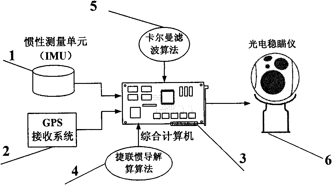
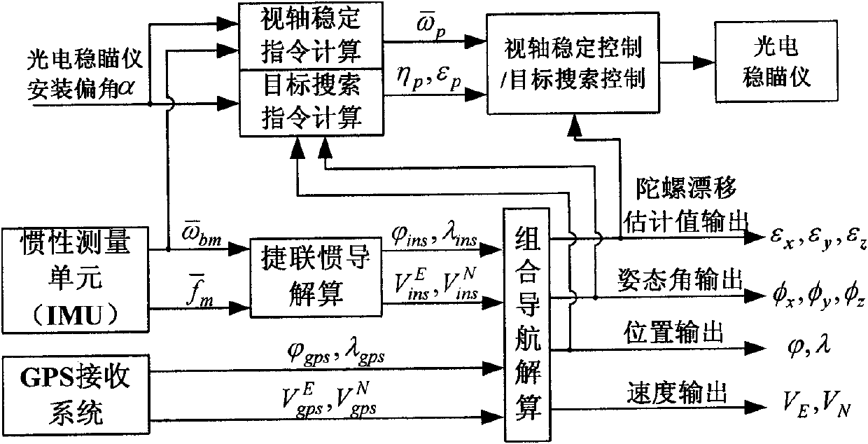
[0037] In the following, the specific implementation process of the present invention will be explained by taking the integrated system of integrated navigation and photoelectric detection of small UAV as an example.

[0038] Such as figure 1 As shown, the integrated airborne navigation and photoelectric detection system of the present invention includes an inertial measurement unit IMU 1, a GPS receiving system 2, an integrated computer 3, and a photoelectric stabilizer 6. The integrated computer 3 collects the data information of the inertial measurement unit 1 and the GPS receiving system 2 to achieve three major functions: 1. Combine the strapdown inertial navigation solution algorithm 4 and the Kalman filter algorithm 5 to perform the inertial / GPS integrated navigation solution to obtain the carrier The position, velocity, and attitude of the inertial measurement unit are estimated at the same time as the drift value of the gyroscope contained in the inertial measurement uni...


PUM


Abstract

The invention relates to an combined navigation and photoelectric detection integrative system, which comprises an inertia measurement unit IMU, a GPS receiving system, an integrated computer and a photoelectric sight-stabilizing instrument, wherein the inertia measurement unit IMU comprises three gyroscopes and three accelerometers; the integrated computer acquires the output information of the inertia measurement unit IMU and the GPS receiving system to realize that (1) inertia and GPS combined navigation resolving is carried out by combining a strapdown inertial navigation resolving algorithm and a Kalman filtering algorithm to obtain the position, the speed and the attitude of a carrier, and meanwhile estimate the drift of the gyroscopes of the inertia measurement unit IMU; (2) the stable instruction angular speed of an optical axis is calculated and the photoelectric sight-stabilizing instrument is controlled to realize the stability of the optical axis, the gyroscope drift estimated by the combined navigation system is utilized to compensate the stable error of the optical axis to improve the stable precision of the optical axis of the photoelectric sight-stabilizing instrument; and (3) the target search instruction angle is calculated and the photoelectric sight-stabilizing instrument is controlled to rapidly search and lock a target by utilizing the position and the attitude information obtained by combined navigation resolving by combing the position information of the target. The invention greatly reduces the volume, the weight and the cost of the system and meanwhile improves the performance of subsystems.

Description

Technical field [0001] The invention relates to an integrated navigation and photoelectric detection integrated system, belonging to the field of inertial navigation technology, inertial / GPS integrated navigation technology and gyro indirect stabilization technology. The integrated navigation / photoelectric detection integrated system can be applied to unmanned reconnaissance aircraft , Tactical missiles, ground combat vehicles, etc. technical background [0002] Navigation system and photoelectric detection system are indispensable sub-systems for intelligent vehicles such as guided weapons, intelligent combat vehicles, and unmanned reconnaissance aircraft. Traditional photoelectric detection systems often use platform-based gyro stabilization schemes, and do not need any information from the navigation system. Their boresight stability is high and the technology is relatively mature, but the volume and weight are relatively large, which is not suitable for comparison of volume a...

Claims


Application Information

Patent Timeline
Patent Type & Authority Applications(China)
IPC IPC(8): G01C21/18G01C21/20
Inventor 徐烨烽孟庆季
Owner BEIHANG UNIV
Why Eureka
Try Eureka