Method for positioning dual-system combined satellite navigation receiver

A technology of satellite navigation and positioning method, which is applied in the field of satellite navigation and communication, and can solve the problems of non-convergence of positioning results and inability to guarantee reliable positioning.

Inactive Publication Date: 2010-08-11
BEIHANG UNIV
View PDF1 Cites 19 Cited by
  • Summary
  • Abstract
  • Description
  • Claims
  • Application Information

AI Technical Summary

Problems solved by technology

[0026] The above conventional method of linearizing the observation equation can obtain good positioning results under normal circumstances, but in some special application environments, such as deep space exploration, the positioning results may not converge, and reliable positioning cannot be guaranteed

Method used


Image

  • Method for positioning dual-system combined satellite navigation receiver
  • Method for positioning dual-system combined satellite navigation receiver
  • Method for positioning dual-system combined satellite navigation receiver

Examples


Embodiment Construction

[0076]Specific embodiments of the present invention will be described below in conjunction with the accompanying drawings.

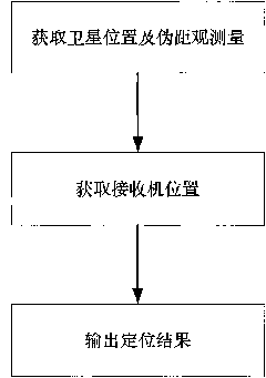
[0077] What the present invention describes is a kind of dual-system combined satellite navigation receiver positioning method, such as figure 1 As shown, the method includes the following steps:

[0078] Step 1: Obtain satellite position and pseudo-range observations;

[0079] After the receiver tracks the satellite signal, the position of the satellite is obtained according to the obtained navigation message; at the same time, the pseudo-range measurement value of the satellite is obtained by the baseband module of the receiver;

[0080] Step 2: Obtain the location of the receiver;

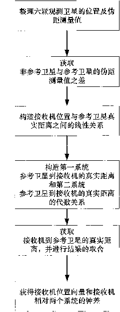
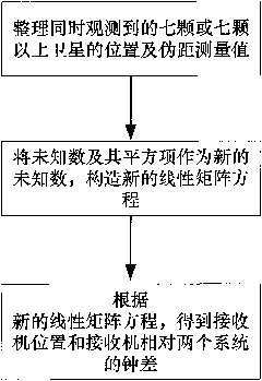
[0081] According to the different situations of the observing satellites, different steps are used to complete the receiver positioning processing. The steps of the receiver positioning method are described in detail below for two different situations.

[0082] The firs...


PUM


Abstract

The invention discloses a method for positioning a dual-system combined satellite navigation receiver, which comprises the following steps of: firstly, acquiring positions of satellites and the pseudo-range observed quantity; secondly, according to different conditions for observing the satellites, adopting different steps to finish the positioning of the receiver so as to acquire the position of the receiver; and finally, outputting positioning results The method has two solutions according to the number of visible satellites: firstly, under the condition that two satellite systems have three visible satellites respectively, the position of the receiver can be acquired finally by using an algebraic processing method of a unary quadratic equation; and secondly, under the condition that the two satellite systems has seven or more visible satellites respectively, an observation equation set is converted into a linear equation set by using the redundancy of observation information, and a least square method is finally used to perform processing directly. The method needs no initial estimated value of a navigation position and also needs no iterated operation processing to ensure that the receiver can obtain a reliable positioning result during a deep space exploration and in other special environments.

Description

technical field [0001] The invention belongs to the field of satellite navigation communication, and in particular relates to a dual-system combined satellite navigation receiver positioning method. Background technique [0002] The global satellite navigation and positioning system has become one of the fastest-growing information industries in the world. It can provide users with positioning, speed measurement and timing services, and has the characteristics of global, all-weather, continuity and real-time. At present, the two existing satellite positioning systems are the Global Positioning System (Global Position System, referred to as GPS) of the United States and the Russian GLONASS system (GLObal Navigation Satellite System, referred to as GLONASS). system and China's BD2 system (Compass system, commonly referred to as BD2). Dual-system combination or multi-system combination satellite navigation receivers will have higher reliability and availability than single-sys...

Claims


Application Information

Patent Timeline
Patent Type & Authority Applications(China)
IPC IPC(8): G01S19/45G01S19/35
Inventor 张晓林张强陈灿辉霍航宇
Owner BEIHANG UNIV
Why Eureka
Try Eureka