Radiation intensity-based method for simulating radiation transfer of complex terrain area

A technology of complex terrain and radiation transmission, applied in the field of remote sensing imaging simulation, it can solve the problems of few parameters, poor applicability, affecting the extraction of remote sensing image information in mountainous areas, etc., and achieve the effect of accurate simulation and calculation

Inactive Publication Date: 2010-11-03
BEIHANG UNIV
View PDF0 Cites 13 Cited by
  • Summary
  • Abstract
  • Description
  • Claims
  • Application Information

AI Technical Summary

Problems solved by technology

[0005] The calculation of the radiant energy received by sensors in complex terrain areas involves many factors, and the existing technologies can be classified into two categories: one is the empirical and semi-empirical methods that lack strict physical meaning, which are characterized by fewer parameters, simple and efficient, and the disadvantage is low accuracy. Second, the physical analytical model based on the principle of radiation transfer has a sound theoretical basis, the model parameters have clear physical meanings, and the simulation accuracy is high. However, the model often makes a lot of simplified approximations to the terrain, and its applicable range is limited.
The correlation between sunlight and the ground surface in complex terrain areas is a complex nonlinear process. Existing technologies ignore some of the influencing factors or simplify the terrain structure, resulting in low accuracy of the simulation results, resulting in a large discrepancy between the simulation results and the reflectance of remote sensing images, seriously Affected information extraction of remote sensing images in mountainous areas

Method used


Image

  • Radiation intensity-based method for simulating radiation transfer of complex terrain area
  • Radiation intensity-based method for simulating radiation transfer of complex terrain area
  • Radiation intensity-based method for simulating radiation transfer of complex terrain area

Examples


Embodiment Construction

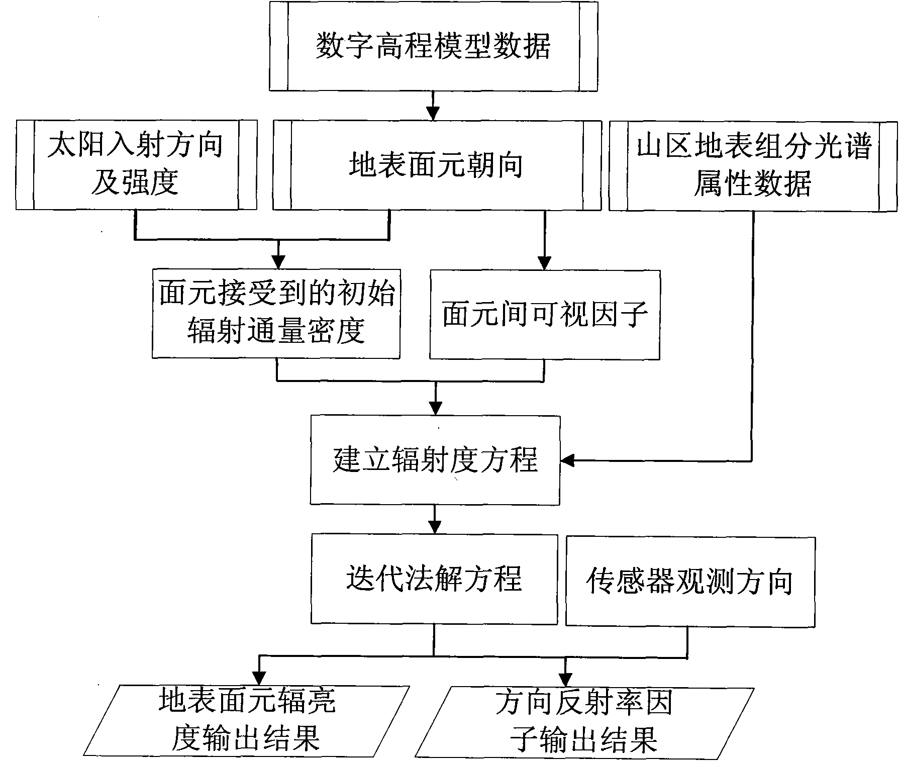
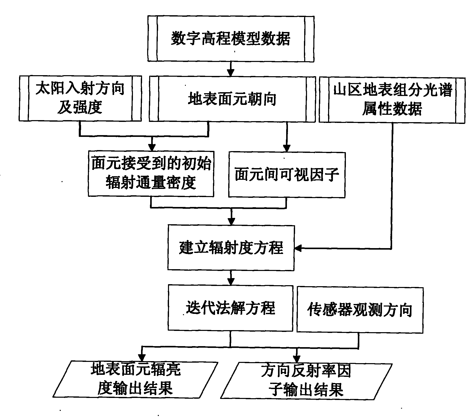
[0045] Taking the remote sensing scene simulation process in the Qulong area of ​​Tibet as an example, as follows: figure 1 Shown, the concrete implementation method of the present invention is as follows:

[0046] (1) Input the digital elevation model of the study area, calculate the orientation of surface grid elements, and prepare data.

[0047] A digital elevation model with a ground resolution of 30m and surface albedo data in the Qulong area of ​​Tibet is used. The simulation calculation time is set at 10:6:56 am on April 3, 2002, and the geographical coordinates of the center of the area are 29.98°N, 36.37°E. According to the pixel coordinate information provided by the digital elevation model data, calculate the normal vector of the vector formed by the two adjacent sides of the surface grid surface element, determine the zenith angle and azimuth angle of the normal vector, and then obtain the surface element's towards.

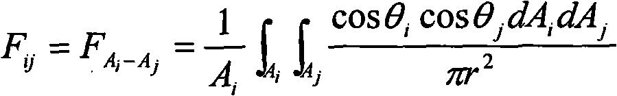
[0048] (2) Input the data such as the incide...


PUM


Abstract

The invention relates to a radiation intensity-based method for simulating the radiation transfer of a complex terrain area. The method comprises the following steps of: (1) inputting a digital elevation model of a research area, calculating the orientations of surficial grid bins and making data preparation; (2) inputting a sun incidence position and energy distribution state data and calculating initial solar radiation flux density received by each surficial grid bin; (3) calculating visible factors among the surficial grid bins by a computer graphics method; (4) inputting spectral characteristic data of the surficial grid bins and establishing a radiation intensity equation of the complex terrain area; (5) solving the radiation intensity equation by a numerical iteration method to obtain the radiation flux density of each surficial grid bin after the radiation is balanced; and (6) calculating a directional reflectance ratio factor and surficial grid bin radiance of the complex terrain area according to the sampling location of a sensor and realizing accurate simulation and calculation of a radiation transfer process of the complex terrain area.

Description

technical field [0001] The invention relates to a radiometric-based radiation transfer simulation method in complex terrain areas, which is suitable for accurate simulation of the remote sensing imaging process under the condition of complex terrain areas in mountainous areas, especially in the quantitative analysis of the impact of terrain on remote sensing images and the correction of image terrain. value, belonging to the field of remote sensing imaging simulation technology. Background technique [0002] In the case of terrain undulations, the ground objects will receive the direct solar light and atmospheric scattered light reflected by the surrounding objects, resulting in an increase in the actual radiation energy received by the ground objects. In the case of snow, vegetation in the near-infrared band, and steep slopes, the influence of the surrounding environment on the reflection of the target object cannot be ignored. While receiving the reflected energy from sur...

Claims


Application Information

Patent Timeline
Patent Type & Authority Applications(China)
IPC IPC(8): G01S7/497
Inventor 赵慧洁赵峰王亚超贾国瑞董艳芳
Owner BEIHANG UNIV
Why Eureka
Try Eureka