Three-dimensional road surface elevation data generation method for vehicle dynamics research

A technology of vehicle dynamics and elevation data, which is applied in the field of 3D road surface elevation data generation in vehicle dynamics research, can solve problems such as fast simulation speed, difference in elevation power spectrum of curved trajectory, and slow simulation speed, so as to achieve good vehicle ride comfort and The effects of steering simulation, good road power spectrum characteristics, and small amount of calculation

Inactive Publication Date: 2012-05-02
ZHEJIANG UNIV
View PDF1 Cites 0 Cited by
  • Summary
  • Abstract
  • Description
  • Claims
  • Application Information

AI Technical Summary

Problems solved by technology

For the harmonic superposition method, the unevenness of the road surface is related to the selection of the reference point, and the simulation speed of this method is slow; for the AR model method, its huge calculation amount can only be applied to a small two-dimensional array, and it cannot generate a large area Terrain, and there is no mature theoretical guidance for the selection of the optimal order of the AR model; the extended single-point inverse Fourier transform method has a fast simulation speed, but the power spectrum of the lateral trajectory of the large-area road surface generated is very different from the actual road surface
At the same time, the difference in the elevation power spectrum of the curved trajectory of the road surface generated by the above method can only be used for ride comfort simulation
To establish a road surface that can be used for the research of vehicle steering and steering-suspension coupling, one method is to obtain the data elevation points of the straight line trajectory through simulation, and according to the difference of the vehicle steering curve trajectory, the corresponding curved road surface is established through programming, which will undoubtedly increase workload

Method used


Image

  • Three-dimensional road surface elevation data generation method for vehicle dynamics research
  • Three-dimensional road surface elevation data generation method for vehicle dynamics research
  • Three-dimensional road surface elevation data generation method for vehicle dynamics research

Examples


Embodiment Construction

[0043] The present invention will be further described below in conjunction with specific examples and accompanying drawings.

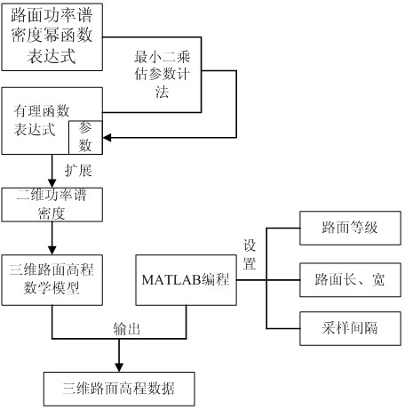
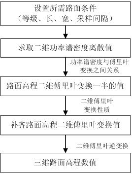
[0044] According to attached figure 1 The technical flow chart shown is to generate road surface elevation data according to requirements in the MATLAB environment, and to test its road surface power spectrum characteristics.

[0045] The first step: compare the parameters in the one-dimensional road power spectrum power function formula (1) specified in GB7031-86

[0046] (1)

[0047] in: is the spatial frequency, that is, the reciprocal of the wavelength, is the reference spatial frequency, is the road surface roughness coefficient, different grades of road surface different. W is the frequency index, and it is the slope under the power spectral density double-logarithmic coordinate graph, which is taken as 2, is the power spectral density.

[0048] The unknown parameters in the rational function expression (2) of...


PUM


Abstract

The invention discloses a three-dimensional road surface elevation data generation method for vehicle dynamics research. The method comprises the following steps of: 1, comparing a road surface roughness power spectrum density power function expression specified by a national standard by a least square nonlinear parameter estimation method to obtain parameters in a road surface roughness power spectrum density rational function expression; 2, extending a one-dimensional power spectrum density rational function expression to acquire two-dimensional power spectrum density, and establishing a three-dimensional road surface elevation mathematical model based on a two-dimensional inverse flourier transform method according to the two-dimensional power spectrum density; and 3, programming in a matrix laboratory (MATLAB) according to the mathematical model obtained in the step 2, and generating three-dimensional road surface elevation data according to required road surface level, road length, width and sampling interval. By the method, the road surface elevation data is quickly generated, power spectrum characteristics of a straight track and a bent track of a road surface are excellent, and the generated data can replace data which is manually measured on site; and the method is suitable for vehicle dynamics research of dynamics software and a virtual prototype of a vehicle.

Description

technical field [0001] The invention relates to the field of vehicle dynamics research, in particular to a method for generating three-dimensional road elevation data for vehicle dynamics research. Background technique [0002] The ride comfort, handling stability and safety of the vehicle are the main performances of the vehicle, and the vehicle dynamics software and virtual prototyping technology are important means for the research of ride comfort and handling stability. The road surface is the main external stimulus of the vehicle. To obtain true and accurate vehicle performance simulation results, the accuracy of the road surface model is particularly important. Most dynamic software and virtual prototypes use 3D models as the road surface stimulus. [0003] To establish a three-dimensional model of the road surface, it is necessary to obtain the road surface elevation data. There are two ways to obtain the road surface elevation data. One is to obtain it through field ...

Claims


Application Information

Patent Timeline
Patent Type & Authority Patents(China)
IPC IPC(8): G06T17/00
Inventor 罗竹辉周晓军魏燕定黎建军杨富春
Owner ZHEJIANG UNIV
Why Eureka
Try Eureka