
Wireless sensor network (WSN)-technology-based indoor three-dimensional accurate positioning method

A precise positioning, three-dimensional technology, applied in the direction of electrical components, wireless communication, network topology, etc., to achieve the effect of saving energy consumption, improving accuracy, and improving positioning accuracy

Inactive Publication Date: 2011-10-12
SUZHOU LIANGJIANG TECH
View PDF0 Cites 18 Cited by
  • Summary
  • Abstract
  • Description
  • Claims
  • Application Information

AI Technical Summary

Problems solved by technology

[0012] The purpose of the present invention is to solve indoor or regional positioning problems that are difficult to solve by positioning methods such as GPS in a low-cost method

Method used


Image

  • Wireless sensor network (WSN)-technology-based indoor three-dimensional accurate positioning method
  • Wireless sensor network (WSN)-technology-based indoor three-dimensional accurate positioning method

Examples


Embodiment Construction

[0031] Give some embodiments to explain the specific technical solutions and some requirements for implementing the invention. On the basis of the technical solution, further explain the content of the invention in detail, and try to put forward some possible technical solutions. For example, the pen may have technologies such as fountain pens and brushes. In addition, it can describe the working principle, how to use and operate, etc. If there are drawings, please describe them in detail in conjunction with the drawings. For example, wireless sensor network nodes are set up in various departments and departments in the office building complex of the government administrative center; when walking in the office building complex (a building) of the government administrative center with a terminal with a wireless sensor network node in hand, the following applies In this way, the positioning of the three-dimensional position can be realized.

[0032] preliminary work:

[0033] ...


PUM


Abstract

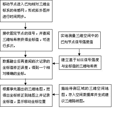
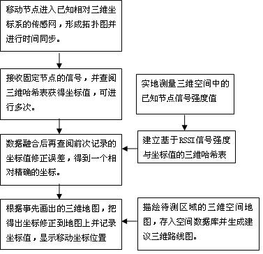
The invention discloses a wireless sensor network (WSN)-technology-based indoor three-dimensional accurate positioning method. WSN indoor three-dimensional accurate positioning is realized by the following steps of: 1) deploying sensor network nodes with known locations in a given area; 2) planning the sensor network nodes with the known locations in a three-dimensional relative coordinate system; 3) establishing a three-dimensional Hash table indicating correspondence between signal intensity and coordinate values in advance, and generating a table lookup KEY value; 4) generating a simple three-dimensional route map for the map of a given area according to possible routes; 5) synchronizing the time of each node by using a wireless sensor network time synchronization algorithm; 6) determining the three-dimensional locations of mobile nodes by continuously exchanging information between the continuously mobile sensor nodes and deployed fixed sensor network anchor nodes; and 7) receiving anchor node signals for many times, and looking up the three-dimensional Hash table to obtain the coordinate values for data fusion. Three-dimensional positioning results are continuously corrected on the three-dimensional route map by continuous circular testing to obtain accurate location coordinates.

Description

technical field [0001] The invention relates to a precise positioning method of a wireless sensor network. Background technique [0002] Global Positioning System GPS (global position system) is currently the most widely used and mature positioning and navigation method. Positioning user nodes through satellite timing and ranging has the advantages of high positioning accuracy, good real-time performance, and strong anti-interference ability. However, GPS positioning and navigation are only suitable for outdoor environments without shelter, and user nodes usually consume a lot of energy. Large, the cost is relatively high, and fixed infrastructure is required. [0003] Wireless sensor network WSN (wireless sensor network) does not require fixed network support, and has the characteristics of rapid deployment and strong invulnerability. Through mutual distance measurement and information exchange between internal nodes in the network, a set of coordinates of the entire netw...

Claims


Application Information

Patent Timeline
Patent Type & Authority Applications(China)
IPC IPC(8): H04W64/00H04W84/18
Inventor 陈国庆陈逸宇
Owner SUZHOU LIANGJIANG TECH
Learn More