
A Method of Correcting the Influence of Atmospheric Refraction on the Accuracy of Star Sensor

A star sensor, atmospheric refraction technology, applied in the field of space science, to achieve the effect of improving efficiency and reducing fuel consumption

Inactive Publication Date: 2011-11-30
HARBIN INST OF TECH
View PDF5 Cites 18 Cited by
  • Summary
  • Abstract
  • Description
  • Claims
  • Application Information

AI Technical Summary

Problems solved by technology

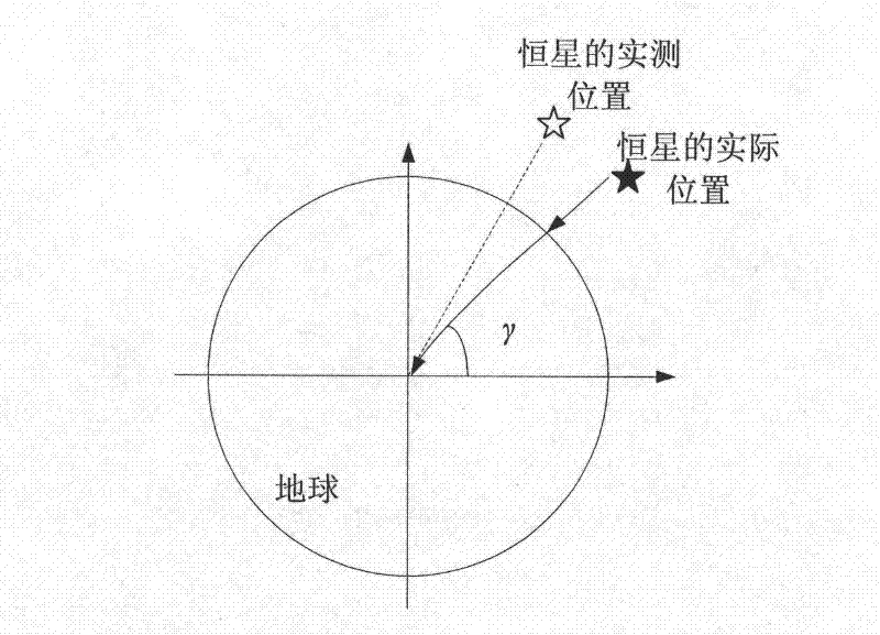
However, when the information of celestial body position is used for navigation on the ground, the influence of atmospheric refraction cannot be avoided, so the research and accurate measurement of atmospheric refraction is an important and unavoidable subject in star sensor navigation

Method used


Image

  • A Method of Correcting the Influence of Atmospheric Refraction on the Accuracy of Star Sensor
  • A Method of Correcting the Influence of Atmospheric Refraction on the Accuracy of Star Sensor
  • A Method of Correcting the Influence of Atmospheric Refraction on the Accuracy of Star Sensor

Examples


Embodiment 1

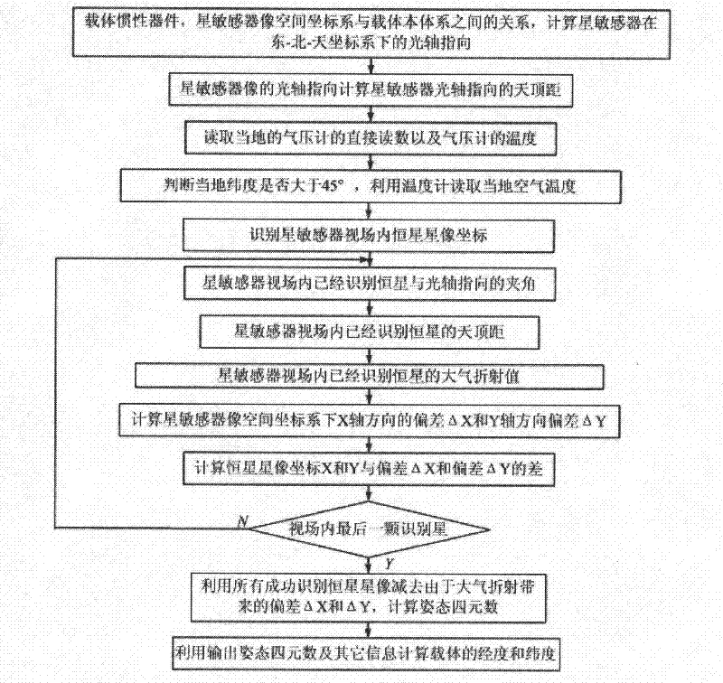
[0038] Example 1: Combining figure 2 , a method for correcting the influence of atmospheric refraction on the accuracy of star sensors in the present invention, the steps are as follows:

[0039] Step 1: Using the carrier inertial device, the relationship between the star sensor image space coordinate system and the carrier body system, calculate the optical axis pointing of the star sensor in the east-north-sky coordinate system;

[0040] Step 2: According to the optical axis pointing of the star sensor image, calculate the zenith distance of the star sensor optical axis pointing, that is, the angle between the star sensor optical axis pointing and the zenith;

[0041] Step 3: Use the barometer to take a direct reading of the local barometer and the temperature of the barometer;

[0042] Step 4: Determine whether the local latitude is greater than 45°, and use a thermometer to read the local air temperature;

[0043] Step 5: Use the star map recognition algorithm to identi...

Embodiment 2

[0057] Example 2: Combining figure 1 , Figure 3-Figure 11 , in order to quantitatively analyze the atmospheric refraction in theory, and considering the complexity of the atmosphere itself, predecessors have established a simplified atmospheric model based on the quiet atmosphere, and established the corresponding atmospheric model on the basis of the model. Refraction tables, further research on atmospheric refraction. In view of the current level of understanding of the atmosphere and scientific and technological capabilities, it is more realistic to establish a more effective atmospheric refraction model that conforms to the geographical environment and meteorological characteristics of the observation point, fully considering complex conditions such as atmospheric tilt, so that it can achieve better accuracy And it can still have high accuracy in the case of large zenith distance (> 70°). Other correction methods for the measurement of atmospheric anomalous refraction sh...

Embodiment 3

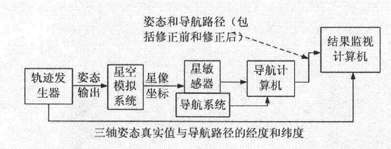
[0093] Example 3: Binding Figure 12 , the local longitude and latitude output by GPS are output to the star sensor in real time. The star sensor recognizes the coordinates of all star images in the field of view through the star map identification. At this time, due to the refraction of the atmosphere, there are deviations in the coordinates of all star images , so these star image coordinates cannot be directly used to calculate the attitude information, and because the angles between the star pointing and the zenith are different, the deviations are also different, so firstly, the local air pressure, air pressure temperature, local latitude and local temperature must be used to calculate these The deviation of the stellar image coordinates due to the atmosphere. The method of calculating the deviation of star image coordinates is as follows: calculate the rough attitude of the current carrier in the east-north-sky coordinate system according to the output of the carrier gyr...


PUM


Abstract

The invention provides a method for correcting the influence of atmospheric refraction on the precision of a star sensor, which comprises the following steps: according to the optic axis orientation of an image of the star sensor, calculating the zenith distance of the optic axis orientation of the star sensor; recognizing the star image coordinates of fixed stars in the viewing field of the starsensor by using a star map recognition algorithm; calculating the zenith distances of the recognized fixed stars in the viewing field of the star sensor; decomposing an atmospheric refraction value into an X-axis direction component and a Y-axis direction component under an image space coordinate system of the star sensor; and subtracting the deviation delta X and delta Y (arising from the atmospheric refraction value) from all successfully-recognized star images of the fixed stars, thus calculating attitude quaternions. When the influence of atmospheric refraction is eliminated, the star sensor can provide high-precision navigation information for shipborne, missile-mounted and airborne aircraft and other aircraft which carry out low-altitude flying; and after carriers adopt atmospheric-refraction-corrected high-precision navigation information, a basis is provided for planning a better navigation path for the carriers, thereby further reducing the fuel consumption of the carriers and improving the efficiency.

Description

(1) Technical field [0001] The invention relates to space science, specifically a method for correcting the influence of atmospheric refraction on the accuracy of a star sensor. (2) Background technology [0002] The star sensor is based on the known accurate space position and the indestructible star, passively detects the position of the celestial body through the photoelectric method, and determines the longitude, latitude, heading and attitude of the platform where the measurement point is located through calculation. The main features are: passive detection, good concealment, no electromagnetic interference, high reliability; autonomous work, independent of other navigation means; high precision, among which the highest orientation accuracy; can work around the clock. As a concealed and reliable means of navigation, the star sensor is mainly used for navigation, calibrating inertial navigation and providing position, heading and attitude information for the carrier syst...

Claims


Application Information

Patent Timeline
Patent Type & Authority Applications(China)
IPC IPC(8): G01C25/00
Inventor 李葆华陈希军奚伯齐温奇咏
Owner HARBIN INST OF TECH
Learn More