Supercharge Your Innovation With Domain-Expert AI Agents!

Satellite signal tracking method and receiver

A satellite signal capture and satellite signal technology, applied in satellite radio beacon positioning systems, measuring devices, instruments, etc., can solve the problems of being vulnerable to shock or vibration, temperature changes, accuracy decline, acceleration sensor errors, etc.

Inactive Publication Date: 2012-03-14
SEIKO EPSON CORP
View PDF1 Cites 11 Cited by
  • Summary
  • Abstract
  • Description
  • Claims
  • Application Information

AI Technical Summary

Problems solved by technology

Although MEMS sensors have advantages such as small size, light weight, low cost, and low power consumption, on the other hand, they have the disadvantage of being vulnerable to external influences such as shocks, vibrations, and temperature changes.
Therefore, due to external influences such as temperature changes or vibrations, there may be large errors in the detection results of the acceleration sensor.
In addition, the accuracy of position calculation may be greatly reduced due to various factors such as the receiving environment of satellite signals such as multipath environment or weak electric field environment, the signal strength of received signals, and the satellite configuration of positioning satellites.

Method used


Image

  • Satellite signal tracking method and receiver
  • Satellite signal tracking method and receiver
  • Satellite signal tracking method and receiver

Examples


Embodiment Construction

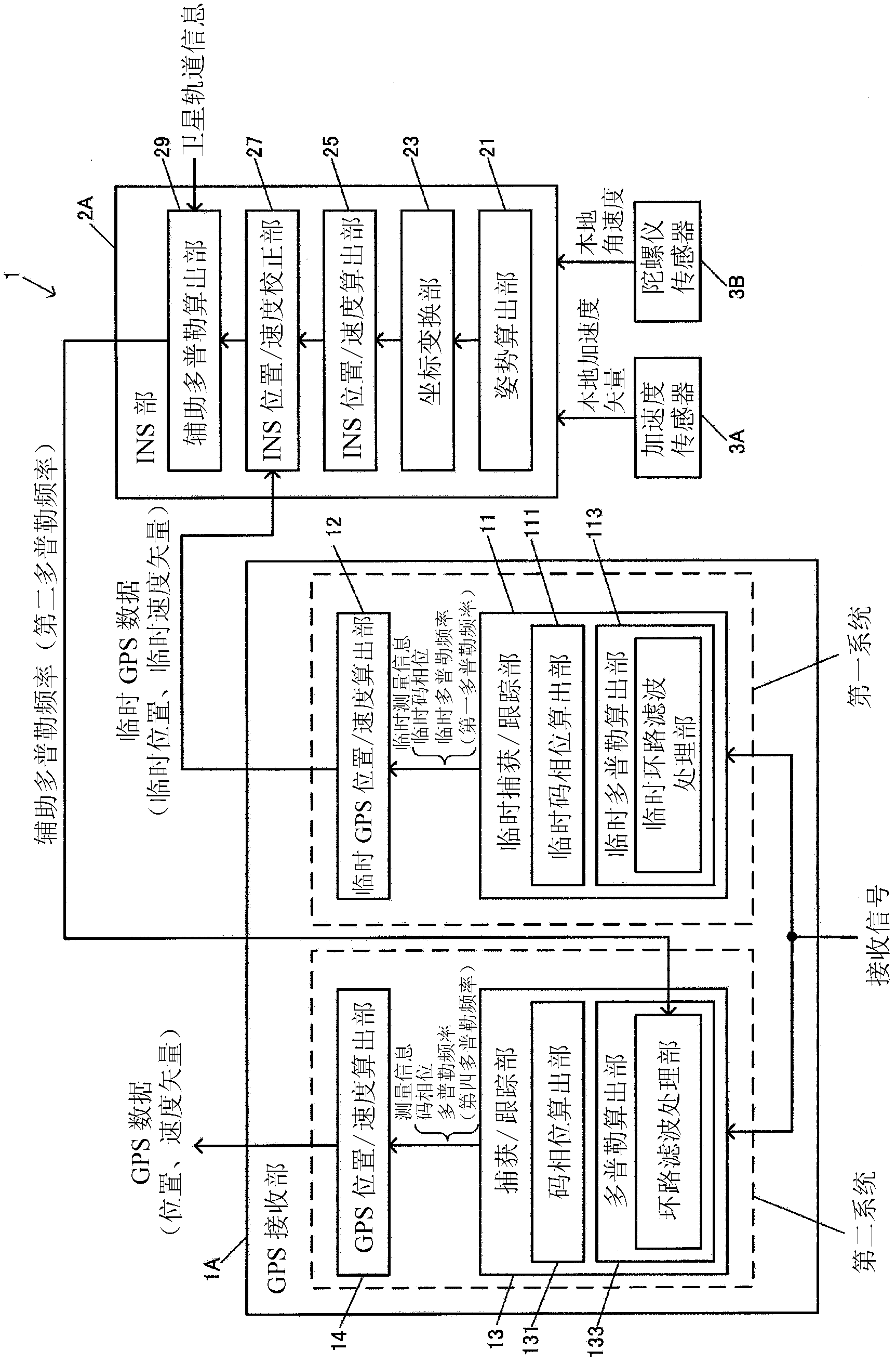
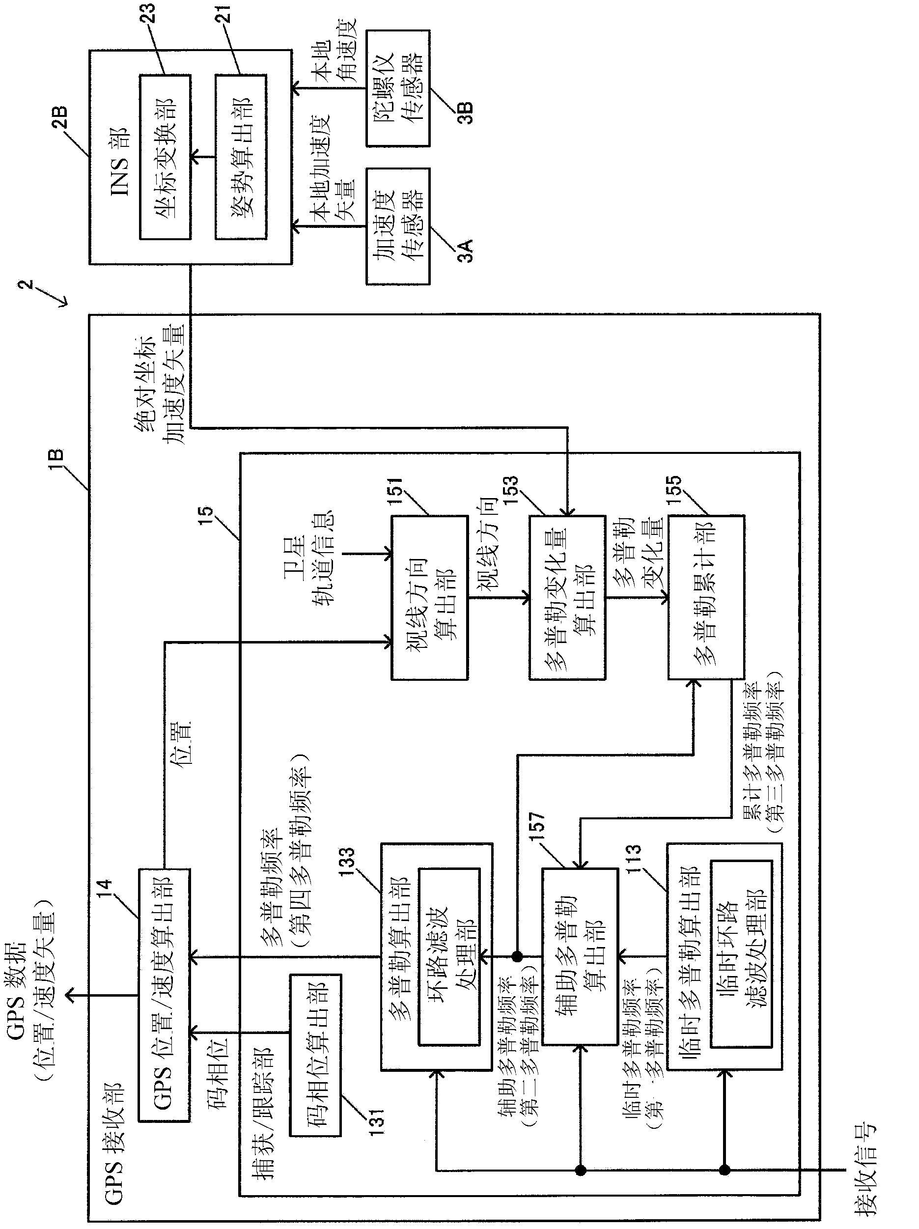
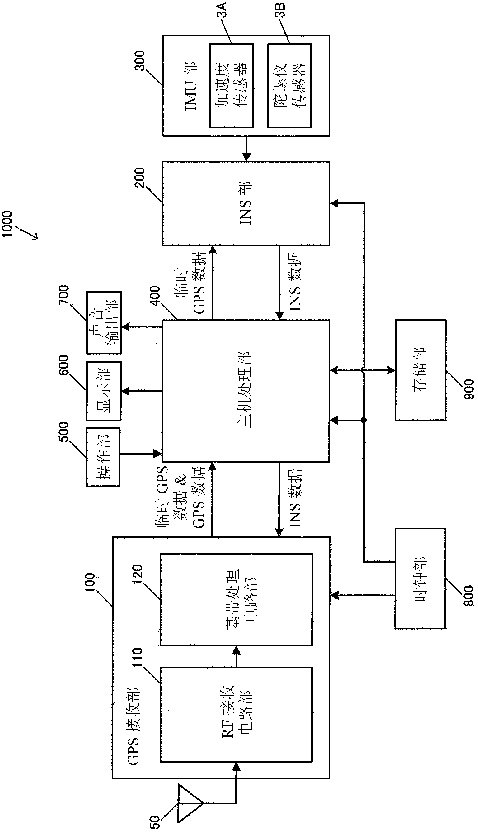
[0050] Hereinafter, an example of a preferred embodiment of the present invention will be described with reference to the accompanying drawings. However, it goes without saying that embodiments to which the present invention can be applied are not limited to the embodiments described below.

[0051] 1. Principle

[0052] First, the principle of position calculation in this embodiment will be described. The present embodiment is an embodiment in which GPS (Global Positioning System) which is a type of satellite positioning system and INS (Inertial Navigation System) which is a type of inertial navigation system are used together to calculate the position of a moving object.

[0053] The main purpose of this embodiment is position calculation, and in order to realize position calculation, acceleration and velocity are also calculated together. Acceleration and velocity have direction and magnitude. Therefore, in this specification, acceleration and velocity are described as "...


PUM


Abstract

A satellite signal tracking method performed by a receiver that receives a satellite signal from a positioning satellite, the satellite signal tracking method including: computing a first Doppler frequency using a received signal obtained by receiving the satellite signal, computing a second Doppler frequency using the first Doppler frequency and a signal from the sensor unit including at least an acceleration sensor, and acquiring the satellite signal using the second Doppler frequency.

Description

technical field [0001] The invention relates to a satellite signal acquisition method and a receiving device. Background technique [0002] GPS (Global Positioning System: Global Positioning System) is already known as a positioning system using satellite signals, and is being applied to position calculation devices built in mobile phones, car navigation devices, and the like. In GPS, position calculation calculation is performed to obtain the position coordinates and clock error of the position calculation device from information such as the positions of a plurality of GPS satellites and the pseudo-ranges from each GPS satellite to the position calculation device. [0003] When a positioning system using satellite signals is used alone, there is a problem that the accuracy of position calculation decreases due to various error factors, and various techniques for improving the accuracy of position calculation have been proposed. For example, Patent Document 1 discloses a te...

Claims


Application Information

Patent Timeline
Patent Type & Authority Applications(China)
IPC IPC(8): G01S19/26G01S19/47
CPCG01S19/26G01S19/29G01S19/254
Inventor 水落俊一松本一实阿南德·库马
Owner SEIKO EPSON CORP
Features
  • R&D
  • Intellectual Property
  • Life Sciences
  • Materials
  • Tech Scout
  • Unparalleled Data Quality
  • Higher Quality Content
  • 60% Fewer Hallucinations
Learn More